
| Memorials | : | 2 |
| Location | : | Guildford, Guildford Borough, England |
| Coordinate | : | 51.2364500, -0.5703050 |
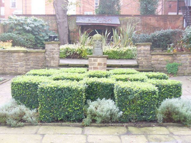
| Description | : | The Society of Friends (Quakers) organized in Guildford during the 1650s and built a Meeting House and burial ground in 1673 at the North Street end of the inn-yard of the Crown. In 1805, a new Meeting House was built across the street, and the original site was used only as a burial ground until it was given to the town in 1927. Called Quakers’ Acre, the former burial site has been turned into a garden for the citizens of Guildford to use as a place of reflection and quiet. |
frequently asked questions (FAQ):
-
Where is Society of Friends Burial Ground (Defunct)?
Society of Friends Burial Ground (Defunct) is located at 77 North Street, Guildford, England Guildford, Guildford Borough ,Surrey , GU1 4ALEngland.
-
Society of Friends Burial Ground (Defunct) cemetery's updated grave count on graveviews.com?
1 memorials
-
Where are the coordinates of the Society of Friends Burial Ground (Defunct)?
Latitude: 51.2364500
Longitude: -0.5703050
Nearby Cemetories:
1. Holy Trinity Church
Guildford, Guildford Borough, England
Coordinate: 51.2357740, -0.5705540
2. St Edwards Churchyard
Guildford, Guildford Borough, England
Coordinate: 51.2339770, -0.5719760
3. St Marys Churchyard
Guildford, Guildford Borough, England
Coordinate: 51.2346622, -0.5744170
4. Saint Nicolas Parish Church
Guildford, Guildford Borough, England
Coordinate: 51.2346980, -0.5776620
5. Guildford Cemetery
Guildford, Guildford Borough, England
Coordinate: 51.2312960, -0.5832800
6. St. John's Churchyard
Stoke-next-Guildford, Guildford Borough, England
Coordinate: 51.2470280, -0.5711690
7. St Mary the Virgin Churchyard
Shalford, Guildford Borough, England
Coordinate: 51.2206700, -0.5705520
8. Stoke Old Cemetery
Guildford, Guildford Borough, England
Coordinate: 51.2522600, -0.5828500
9. Stoke New Cemetery
Guildford, Guildford Borough, England
Coordinate: 51.2543900, -0.5824700
10. Shalford Cemetery
Shalford, Guildford Borough, England
Coordinate: 51.2152000, -0.5687000
11. St Martha-on-the-Hill Churchyard
Chilworth, Guildford Borough, England
Coordinate: 51.2246400, -0.5290440
12. St John the Evangelist Churchyard
Merrow, Guildford Borough, England
Coordinate: 51.2459770, -0.5271350
13. Burpham Churchyard
Guildford, Guildford Borough, England
Coordinate: 51.2622640, -0.5497350
14. Guildford Crematorium
Guildford, Guildford Borough, England
Coordinate: 51.2037790, -0.5900520
15. St Edward the Confessor Churchyard
Sutton Green, Woking Borough, England
Coordinate: 51.2741930, -0.5608230
16. St. John the Baptist Churchyard
Wonersh, Waverley Borough, England
Coordinate: 51.1960610, -0.5493600
17. St Mary the Virgin Churchyard
Worplesdon, Guildford Borough, England
Coordinate: 51.2730100, -0.6067360
18. St. Peter & St. Paul's Churchyard
West Clandon, Guildford Borough, England
Coordinate: 51.2507990, -0.5053760
19. Compton Village Cemetery
Compton, Guildford Borough, England
Coordinate: 51.2181370, -0.6326920
20. Old Quaker Burial Ground
Godalming, Waverley Borough, England
Coordinate: 51.2043160, -0.6169070
21. Ss Peter & Paul Church Cemetery
West Clandon, Guildford Borough, England
Coordinate: 51.2517500, -0.5045400
22. St. John's Churchyard
Godalming, Waverley Borough, England
Coordinate: 51.1959270, -0.6036480
23. St. Nicholas' Churchyard
Compton, Guildford Borough, England
Coordinate: 51.2145300, -0.6348400
24. St Mary the Virgin Churchyard
Send, Guildford Borough, England
Coordinate: 51.2791230, -0.5408600