
| Memorials | : | 29 |
| Location | : | Countesthorpe, Blaby District, England |
| Phone | : | +441162581871 |
| Website | : | www.southleicestermemorial.co.uk/ |
| Coordinate | : | 52.5562541, -1.1289665 |
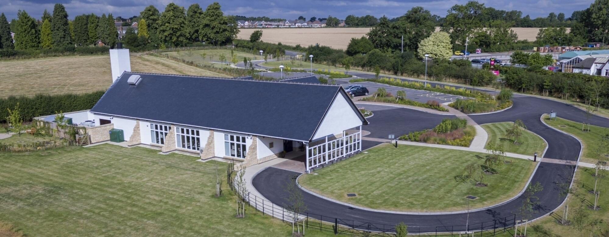
| Description | : | The South Leicestershire Memorial Park and Crematorium is located on the on the Foston Road at the northern end of Countethorpe, and has been designed to blend in with the existing Countesthorpe cemetery next door. Visitors to the cemetery may use the extra car parking provided at the crematorium; and the crematorium chapel can also be booked for burial services. The Garden of Remembrance offers memorialisation made exclusively from British stone, and so will blend perfectly with the surrounding Leicestershire countryside. The chapel seats 100 people, it has the potential to stand and seat 200 by including the foyer space, and can... Read More |
frequently asked questions (FAQ):
-
Where is South Leicestershire Memorial Park and Crematorium?
South Leicestershire Memorial Park and Crematorium is located at Foston Road Countesthorpe, Blaby District ,Leicestershire , LE8 5QPEngland.
-
South Leicestershire Memorial Park and Crematorium cemetery's updated grave count on graveviews.com?
29 memorials
-
Where are the coordinates of the South Leicestershire Memorial Park and Crematorium?
Latitude: 52.5562541
Longitude: -1.1289665
Nearby Cemetories:
1. Countesthorpe Parish Cemetery
Countesthorpe, Blaby District, England
Coordinate: 52.5577540, -1.1309080
2. St Andrew's Churchyard
Countesthorpe, Blaby District, England
Coordinate: 52.5536270, -1.1379810
3. St Bartholomew in Foston
Kilby, Blaby District, England
Coordinate: 52.5494780, -1.1117810
4. St. Bartholomew's Churchyard
Foston, Blaby District, England
Coordinate: 52.5494850, -1.1116260
5. Blaby Cemetery
Blaby, Blaby District, England
Coordinate: 52.5738950, -1.1541280
6. St Mary Magdalene
Kilby, Blaby District, England
Coordinate: 52.5554660, -1.0884320
7. Wigston Cemetery
Wigston, Oadby and Wigston Borough, England
Coordinate: 52.5752060, -1.1007170
8. All Saints Churchyard
Blaby, Blaby District, England
Coordinate: 52.5754960, -1.1600850
9. All Saints Churchyard
Wigston, Oadby and Wigston Borough, England
Coordinate: 52.5823880, -1.1096900
10. All Saints Churchyard
Peatling Magna, Harborough District, England
Coordinate: 52.5267900, -1.1247040
11. Wigston United Reformed Church
Wigston, Oadby and Wigston Borough, England
Coordinate: 52.5840900, -1.1071200
12. St Mary's Churchyard
Willoughby Waterleys, Harborough District, England
Coordinate: 52.5270920, -1.1532770
13. Whetstone Cemetery
Whetstone, Blaby District, England
Coordinate: 52.5722900, -1.1779200
14. St Wistan's Churchyard
Wigston, Oadby and Wigston Borough, England
Coordinate: 52.5866580, -1.1024700
15. Saint Peter's Churchyard
Whetstone, Blaby District, England
Coordinate: 52.5727910, -1.1788510
16. Saffron Hill Cemetery
Leicester, Leicester Unitary Authority, England
Coordinate: 52.5934120, -1.1310010
17. Baptist Chapel Churchyard
Arnesby, Harborough District, England
Coordinate: 52.5264000, -1.0909600
18. St Peter Churchyard
Arnesby, Harborough District, England
Coordinate: 52.5240840, -1.0918950
19. St Michael and All Angels Churchyard
Cosby, Blaby District, England
Coordinate: 52.5488260, -1.1933700
20. Cosby Cemetery
Cosby, Blaby District, England
Coordinate: 52.5560490, -1.1962970
21. St Luke's Churchyard, Newton Harcourt
Wistow, Harborough District, England
Coordinate: 52.5646320, -1.0577376
22. St Wistans Church
Wistow, Harborough District, England
Coordinate: 52.5577010, -1.0522340
23. All Saints Churchyard
Narborough, Blaby District, England
Coordinate: 52.5730420, -1.2038480
24. Oadby Cemetery
Oadby, Oadby and Wigston Borough, England
Coordinate: 52.5961580, -1.0826170