
| Memorials | : | 33 |
| Location | : | Southfield, Oakland County, USA |
| Coordinate | : | 42.4749985, -83.2608032 |
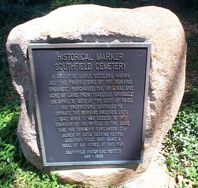
| Description | : | According to tradition, the first interment here was as early as 1828. In May 1968 the cemetery was designated a historical site by the Southfield Historical Society. The marker describes how a group of early settlers known as ‘the proprietors of the burying grounds’ purchased the original one acre of land from Thaddeus Griswold on April 18, 1833 at the cost of $8.00. The proprietors continued to operate the burying grounds until 1847 when it was deeded to the Township of Southfield. At the same time the Township purchased 2 1/2 acres of land costing $37.50. Additions... Read More |
frequently asked questions (FAQ):
-
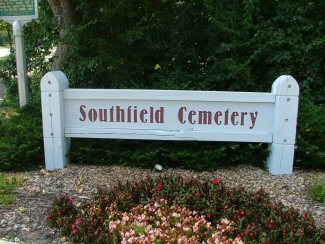
Where is Southfield Cemetery?
Southfield Cemetery is located at 24366 W 10 & Half Mile Rd Southfield, Oakland County ,Michigan , 48075USA.
-
Southfield Cemetery cemetery's updated grave count on graveviews.com?
28 memorials
-
Where are the coordinates of the Southfield Cemetery?
Latitude: 42.4749985
Longitude: -83.2608032

Nearby Cemetories:
1. Pioneer Cemetery
Southfield, Oakland County, USA
Coordinate: 42.4749140, -83.2603170
2. Southfield Reformed Cemetery
Southfield, Oakland County, USA
Coordinate: 42.4848420, -83.2405580
3. Dun Scotus - Franciscan Catholic Cemetery
Southfield, Oakland County, USA
Coordinate: 42.4609690, -83.2437940
4. Holy Sepulchre Cemetery
Southfield, Oakland County, USA
Coordinate: 42.4813995, -83.3028030
5. Greater Grace Temple of the Apostolic Faith Garden
Detroit, Wayne County, USA
Coordinate: 42.4297295, -83.2711334
6. Saint David Episcopal Church Columbarium
Southfield, Oakland County, USA
Coordinate: 42.5030990, -83.2096400
7. Beekman Cemetery
Southfield, Oakland County, USA
Coordinate: 42.5098076, -83.2176285
8. Mount Hazel Cemetery
Detroit, Wayne County, USA
Coordinate: 42.4253006, -83.2566986
9. Northbrook Presbyterian Church Columbarium
Beverly Hills, Oakland County, USA
Coordinate: 42.5297550, -83.2657280
10. Acacia Park Cemetery
Beverly Hills, Oakland County, USA
Coordinate: 42.5217018, -83.2197037
11. Congregation for Humanistic Judaism Peace Garden
Farmington Hills, Oakland County, USA
Coordinate: 42.4989110, -83.3299670
12. East Farmington Cemetery
Farmington Hills, Oakland County, USA
Coordinate: 42.5003014, -83.3296967
13. Grand Lawn Cemetery
Detroit, Wayne County, USA
Coordinate: 42.4188995, -83.2724991
14. Franklin Cemetery
Franklin, Oakland County, USA
Coordinate: 42.5224991, -83.3059921
15. Nardin Park United Methodist Church Memorial Garde
Farmington Hills, Oakland County, USA
Coordinate: 42.4848680, -83.3414050
16. Saint Mary of Redford Cemetery (Defunct)
Redford, Wayne County, USA
Coordinate: 42.4147600, -83.2531930
17. Franklin Community Church Columbarium
Franklin, Oakland County, USA
Coordinate: 42.5258470, -83.3100450
18. Clarenceville Cemetery
Livonia, Wayne County, USA
Coordinate: 42.4411011, -83.3324966
19. Roseland Park Cemetery
Berkley, Oakland County, USA
Coordinate: 42.5060997, -83.1797028
20. Redford Cemetery
Redford, Wayne County, USA
Coordinate: 42.4063988, -83.2752991
21. Mount Calvary Cemetery
Detroit, Wayne County, USA
Coordinate: 42.4073490, -83.2358180
22. First United Methodist Church Memorial Garden
Birmingham, Oakland County, USA
Coordinate: 42.5454370, -83.2330870
23. Lutheran Church of the Redeemer Columbarium
Birmingham, Oakland County, USA
Coordinate: 42.5463540, -83.2373950
24. First Presbyterian Church Columbarium
Birmingham, Oakland County, USA
Coordinate: 42.5463380, -83.2351040