
| Memorials | : | 0 |
| Location | : | Washington Township, Smith County, USA |
| Coordinate | : | 39.9154700, -98.7424900 |
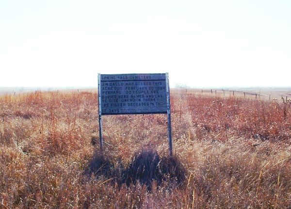
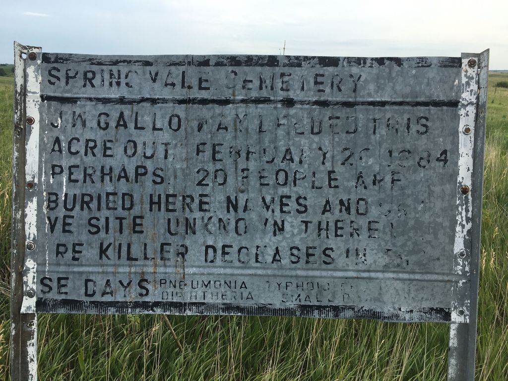
| Description | : | This rural cemetery is located 3 miles east and 9 miles north of Smith Center, Kansas, on the south side of 70 road, 3/4 mile west of S road. A sign mounted at the cemetery provides this information: "J. W. Galloway deeded this acre out Feb 20, 1884 to be used as a cemetery. There are perhaps 20 people buried here. Names and grave sites are unknown". |
frequently asked questions (FAQ):
-
Where is Spring Vale Cemetery?
Spring Vale Cemetery is located at Washington Township, Smith County ,Kansas ,USA.
-
Spring Vale Cemetery cemetery's updated grave count on graveviews.com?
0 memorials
-
Where are the coordinates of the Spring Vale Cemetery?
Latitude: 39.9154700
Longitude: -98.7424900
Nearby Cemetories:
1. Eminence Cemetery
Thornburg, Smith County, USA
Coordinate: 39.9432983, -98.8005981
2. Womer Cemetery
Womer, Smith County, USA
Coordinate: 39.9736400, -98.7110800
3. Cedar Hill Cemetery
Cora, Smith County, USA
Coordinate: 39.8863200, -98.6550000
4. Reamsville Cemetery
Reamsville, Smith County, USA
Coordinate: 39.9441500, -98.8593500
5. Reamsville Methodist Church Cemetery
Reamsville, Smith County, USA
Coordinate: 39.9299500, -98.8693970
6. William Nelson Gravesite
Athol, Smith County, USA
Coordinate: 39.8866080, -98.8708130
7. Oriole Cemetery
Lebanon, Smith County, USA
Coordinate: 39.9366400, -98.5938300
8. Meade Cemetery
Reamsville, Smith County, USA
Coordinate: 39.8680992, -98.8839035
9. Oak Hill Cemetery
Lebanon, Smith County, USA
Coordinate: 39.8437010, -98.6186200
10. Fairview Cemetery
Smith Center, Smith County, USA
Coordinate: 39.7966995, -98.7881012
11. Mount Hope Cemetery
Lebanon, Smith County, USA
Coordinate: 39.9721800, -98.5799700
12. Pleasant Hill Cemetery
Reamsville, Smith County, USA
Coordinate: 39.9510994, -98.9175034
13. Walnut Creek Cemetery
Inavale, Webster County, USA
Coordinate: 40.0463982, -98.6793976
14. Zion Cemetery
Athol, Smith County, USA
Coordinate: 39.8434100, -98.9171700
15. Pleasant Plains Cemetery
Lebanon, Smith County, USA
Coordinate: 39.8793400, -98.5419400
16. Price Cemetery
Oak Township, Smith County, USA
Coordinate: 39.7986860, -98.5993060
17. Fuller Cemetery
Riverton, Franklin County, USA
Coordinate: 40.0764000, -98.7925700
18. Mount Pleasant Cemetery
Webster County, USA
Coordinate: 40.0491982, -98.6125031
19. Pleasant View Cemetery
Athol, Smith County, USA
Coordinate: 39.7859000, -98.8982000
20. Riverton Cemetery
Riverton, Franklin County, USA
Coordinate: 40.0970993, -98.7530975
21. Gust Cemetery
Webster County, USA
Coordinate: 40.0172005, -98.5421982
22. Webb Hill Cemetery
Lebanon, Smith County, USA
Coordinate: 39.9520200, -98.5045200
23. Salem Cemetery
Esbon, Jewell County, USA
Coordinate: 39.8755989, -98.5006027
24. Stevens Cemetery
Riverton, Franklin County, USA
Coordinate: 40.0977000, -98.8201500