
| Memorials | : | 0 |
| Location | : | Wakefield, Metropolitan Borough of Wakefield, England |
| Coordinate | : | 53.6826980, -1.4898550 |
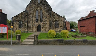
| Description | : | St Andrews C of E Church is listed under the Wakefield Places of Worship category and is located in Peterson Rd , Wakefield, West Yorkshire. It can be reached at phone number 01924 372105. Parish church of 1846 by G.G. Scott, reordered in the 1970s by R. Shepley. MATERIALS: Coursed, rock-faced sandstone with freestone dressings, replacement thin slates to nave and chancel roofs, original thick graded slates to lean-to aisles. PLAN: Aisled nave, lower chancel with north vestry and C20 north-east extensions EXTERIOR: Early-English style parish church with steep nave roof behind coped gables, and lean-to aisles, consistent use of hood moulds with head... Read More |
frequently asked questions (FAQ):
-
Where is St Andrew and St Mary Churchyard?
St Andrew and St Mary Churchyard is located at Peterson Rd Wakefield, Metropolitan Borough of Wakefield ,West Yorkshire , WF1 4DXEngland.
-
St Andrew and St Mary Churchyard cemetery's updated grave count on graveviews.com?
0 memorials
-
Where are the coordinates of the St Andrew and St Mary Churchyard?
Latitude: 53.6826980
Longitude: -1.4898550
Nearby Cemetories:
1. Vicar’s Croft Burial Ground (Defunct)
Wakefield, Metropolitan Borough of Wakefield, England
Coordinate: 53.6833820, -1.4943720
2. Wakefield Cathedral Churchyard
Wakefield, Metropolitan Borough of Wakefield, England
Coordinate: 53.6828910, -1.4962640
3. West Parade Wesleyan Methodist Burial Ground
Wakefield, Metropolitan Borough of Wakefield, England
Coordinate: 53.6795410, -1.4954980
4. Westgate Chapel
Wakefield, Metropolitan Borough of Wakefield, England
Coordinate: 53.6823200, -1.5042600
5. Wakefield Cemetery
Wakefield, Metropolitan Borough of Wakefield, England
Coordinate: 53.6727220, -1.4853820
6. St. John The Baptist Churchyard
Wakefield, Metropolitan Borough of Wakefield, England
Coordinate: 53.6883040, -1.5055020
7. St. James with Christ Churchyard
Thornes, Metropolitan Borough of Wakefield, England
Coordinate: 53.6727700, -1.5023350
8. Unitarian Burial Ground
Wakefield, Metropolitan Borough of Wakefield, England
Coordinate: 53.6796218, -1.5125998
9. St Michael Churchyard
Wakefield, Metropolitan Borough of Wakefield, England
Coordinate: 53.6790820, -1.5135400
10. Kirkthorpe St Peter's Church
Wakefield, Metropolitan Borough of Wakefield, England
Coordinate: 53.6837930, -1.4543120
11. St Peter the Apostle Churchyard
Warmfield, Metropolitan Borough of Wakefield, England
Coordinate: 53.6837930, -1.4541410
12. St. Peter Churchyard Extension Cemetery
Warmfield, Metropolitan Borough of Wakefield, England
Coordinate: 53.6833560, -1.4538230
13. St Helen Churchyard
Sandal, Metropolitan Borough of Wakefield, England
Coordinate: 53.6591900, -1.4821480
14. St Paul Churchyard
Alverthorpe, Metropolitan Borough of Wakefield, England
Coordinate: 53.6921960, -1.5320940
15. Alverthorpe Cemetery
Alverthorpe, Metropolitan Borough of Wakefield, England
Coordinate: 53.6926990, -1.5318500
16. Outwood Cemetery
Outwood, Metropolitan Borough of Wakefield, England
Coordinate: 53.7105970, -1.5011840
17. St. Mary Magdelene Churchyard
Outwood, Metropolitan Borough of Wakefield, England
Coordinate: 53.7112550, -1.5012190
18. St Peter Churchyard
Stanley, Metropolitan Borough of Wakefield, England
Coordinate: 53.7136330, -1.4712940
19. Stanley Cemetery
Stanley, Metropolitan Borough of Wakefield, England
Coordinate: 53.7147890, -1.4735250
20. St. Mary's Churchyard
Horbury, Metropolitan Borough of Wakefield, England
Coordinate: 53.6596419, -1.5390711
21. First Ossett Baptist Cemetery
Ossett, Metropolitan Borough of Wakefield, England
Coordinate: 53.6741000, -1.5536900
22. Wakefield Crematorium
Crigglestone, Metropolitan Borough of Wakefield, England
Coordinate: 53.6437850, -1.5147430
23. Altofts Cemetery
Altofts, Metropolitan Borough of Wakefield, England
Coordinate: 53.7089350, -1.4352310
24. Crigglestone Cemetery
Crigglestone, Metropolitan Borough of Wakefield, England
Coordinate: 53.6432430, -1.5161240