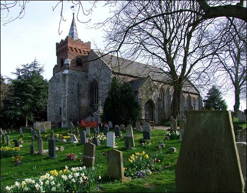
| Memorials | : | 3 |
| Location | : | Costessey, South Norfolk District, England |
| Coordinate | : | 52.6660400, 1.2183410 |
| Description | : | Costessey is famously pronounced Cossey, and is spelt that way in some older documents. Despite the traffic, old Costessey still has something of the character of a village. The parish also contains a vast housing estate, a suburb of Norwich down towards the Dereham Road, but St Edmund is away from all that, and its narrow, pretty graveyard is a peaceful spot. There are a number of interesting stones, including an unusual 19th century tombchest decorated with floral medallions which I think may be constructed from the locally produced cosseyware, and an excellent late 18th century classical structure surmounted by... Read More |
frequently asked questions (FAQ):
-
Where is St. Edmund's Churchyard?
St. Edmund's Churchyard is located at Costessey, South Norfolk District ,Norfolk ,England.
-
St. Edmund's Churchyard cemetery's updated grave count on graveviews.com?
3 memorials
-
Where are the coordinates of the St. Edmund's Churchyard?
Latitude: 52.6660400
Longitude: 1.2183410
Nearby Cemetories:
1. Costessey Baptist Churchyard
Costessey, South Norfolk District, England
Coordinate: 52.6600122, 1.2116993
2. Our Lady & St. Walstan Churchyard
Costessey, South Norfolk District, England
Coordinate: 52.6583200, 1.2119300
3. St. Margaret's Churchyard
Drayton, Broadland District, England
Coordinate: 52.6773010, 1.2241980
4. Costessey Parish Cemetery
Costessey, South Norfolk District, England
Coordinate: 52.6495927, 1.2040157
5. St. Edmund's Churchyard
Taverham, Broadland District, England
Coordinate: 52.6789990, 1.1949460
6. St. Mary's New Burial Ground
Hellesdon, Broadland District, England
Coordinate: 52.6495480, 1.2520370
7. St. Mary's Churchyard
Hellesdon, Broadland District, England
Coordinate: 52.6486720, 1.2515280
8. St Michael's Church
Bowthorpe, City of Norwich, England
Coordinate: 52.6359300, 1.2163600
9. All Saints Churchyard
Horsford, Broadland District, England
Coordinate: 52.6913720, 1.2494360
10. St. Mary's Churchyard
Earlham, City of Norwich, England
Coordinate: 52.6280416, 1.2353034
11. Horsham St. Faith cemetery
Horsham St Faith, Broadland District, England
Coordinate: 52.6870250, 1.2758110
12. St. Andrew Churchyard
Colney, South Norfolk District, England
Coordinate: 52.6253800, 1.2206100
13. St. Mary and St. Walstan Churchyard
Bawburgh, South Norfolk District, England
Coordinate: 52.6327480, 1.1796530
14. St. Peter's Churchyard
Ringland, Broadland District, England
Coordinate: 52.6822900, 1.1552400
15. St. Mary and St. Andrew Churchyard
Horsham St Faith, Broadland District, England
Coordinate: 52.6880970, 1.2771330
16. Colney Woodland Burial Park
Colney, South Norfolk District, England
Coordinate: 52.6254580, 1.1991560
17. St. Bartholomew's Churchyard Heigham
Norwich, City of Norwich, England
Coordinate: 52.6401560, 1.2743680
18. Horsham St. Faith Priory
Horsham St Faith, Broadland District, England
Coordinate: 52.6888310, 1.2783290
19. St Margaret Churchyard
Felthorpe, Broadland District, England
Coordinate: 52.7099700, 1.2105700
20. St. Peter's Churchyard
Easton, South Norfolk District, England
Coordinate: 52.6543660, 1.1478070
21. Earlham Road Cemetery
Norwich, City of Norwich, England
Coordinate: 52.6305900, 1.2677400
22. Old Catton Churchyard
Norwich, City of Norwich, England
Coordinate: 52.6627000, 1.2969770
23. St. Margaret's Churchyard
Catton, Broadland District, England
Coordinate: 52.6626280, 1.2970190
24. St Faith Crematorium
Horsham St Faith, Broadland District, England
Coordinate: 52.6967970, 1.2817680

