
| Memorials | : | 0 |
| Location | : | Oosterhout, Oosterhout Municipality, Netherlands |
| Phone | : | +31 162 453 574 |
| Coordinate | : | 51.6410220, 4.8616900 |
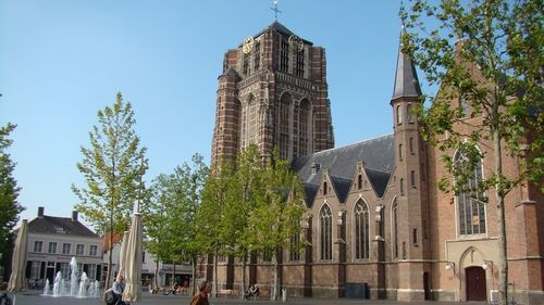
| Description | : | The Basilica of St John the Baptist is a beautiful, stately church in Oosterhout. The construction of the present church began around 1473 at the site where a much smaller tuff stone Romanesque church stood since the early 11th century. The 'unfinished' tower is inspired by the church tower of the Grote Kerk in Breda. Construction of the tower started in 1519. For history buffs, an interesting fact is that the tower was used as an observation post by the Spanish troops during the Siege of Breda in 1625. Thereafter, the troops of Frederick Henry, Prince of Orange set fire... Read More |
frequently asked questions (FAQ):
-
Where is St. John the Baptist Cemetery?
St. John the Baptist Cemetery is located at Markt 17 Oosterhout, Oosterhout Municipality ,Noord-Brabant , 4901 EPNetherlands.
-
St. John the Baptist Cemetery cemetery's updated grave count on graveviews.com?
0 memorials
-
Where are the coordinates of the St. John the Baptist Cemetery?
Latitude: 51.6410220
Longitude: 4.8616900
Nearby Cemetories:
1. Oosterhout Protestant Cemetery
Oosterhout, Oosterhout Municipality, Netherlands
Coordinate: 51.6415100, 4.8510800
2. R.K.Begraafplaats St Joannes de Doper
Oosteind, Oosterhout Municipality, Netherlands
Coordinate: 51.6451595, 4.9015936
3. Joodse Begraafplaats
Oosterhout, Oosterhout Municipality, Netherlands
Coordinate: 51.6396000, 4.8201600
4. Dongen De Kremer Cemetery
Dongen, Dongen Municipality, Netherlands
Coordinate: 51.6300790, 4.9118010
5. R.K. Begraafplaats Heilige Cornelius
Den Hout, Oosterhout Municipality, Netherlands
Coordinate: 51.6600504, 4.8136076
6. Begraafplaats Teteringen
Teteringen, Breda Municipality, Netherlands
Coordinate: 51.6112929, 4.8165026
7. Dongen Roman Catholic Cemetery
Dongen, Dongen Municipality, Netherlands
Coordinate: 51.6323900, 4.9389800
8. Begraafplaats St Marcoen
Dorst, Oosterhout Municipality, Netherlands
Coordinate: 51.5906301, 4.8581754
9. Raamsdonk Roman Catholic Cemetery
Raamsdonk, Geertruidenberg Municipality, Netherlands
Coordinate: 51.6875200, 4.9059100
10. Made-en-Drimmelen Protestant Churchyard
Made, Drimmelen Municipality, Netherlands
Coordinate: 51.6790700, 4.7977900
11. Oude Begraafplaats
Made, Drimmelen Municipality, Netherlands
Coordinate: 51.6722400, 4.7854625
12. Made General Cemetery
Made, Drimmelen Municipality, Netherlands
Coordinate: 51.6709734, 4.7794867
13. Begraafplaats van de Bernardusparochie
Made, Drimmelen Municipality, Netherlands
Coordinate: 51.6823618, 4.7934563
14. Terheijden Antonius Abt Kerkhof
Terheijden, Drimmelen Municipality, Netherlands
Coordinate: 51.6425700, 4.7518400
15. St. Bartholomeuskerk Cemetery
Waspik, Waalwijk Municipality, Netherlands
Coordinate: 51.6863970, 4.9465918
16. St. Theresia van Lisieux Cemetery
Waspik-Boven, Waalwijk Municipality, Netherlands
Coordinate: 51.6757453, 4.9602146
17. Waspik Protestant Churchyard
Waspik, Waalwijk Municipality, Netherlands
Coordinate: 51.6878900, 4.9465900
18. de Roonlaan Cemetery
Waspik, Waalwijk Municipality, Netherlands
Coordinate: 51.6924608, 4.9421490
19. Oude Begraafplaats
Oud-Drimmelen, Drimmelen Municipality, Netherlands
Coordinate: 51.6953428, 4.7815527
20. Our Lady's Church
Breda, Breda Municipality, Netherlands
Coordinate: 51.5890900, 4.7753160
21. Breda Grote Kerk
Breda, Breda Municipality, Netherlands
Coordinate: 51.5890000, 4.7750000
22. Begraafplaats Parochie H Gummarus
Wagenberg, Drimmelen Municipality, Netherlands
Coordinate: 51.6646339, 4.7468280
23. Markendaalse Kerk Cemetery
Breda, Breda Municipality, Netherlands
Coordinate: 51.5887628, 4.7710466
24. Bavel Katholieke Begraafplaats
Bavel, Breda Municipality, Netherlands
Coordinate: 51.5659700, 4.8294800