| Memorials | : | 0 |
| Location | : | Lawley, Telford and Wrekin Unitary Authority, England |
| Coordinate | : | 52.6751550, -2.4932670 |
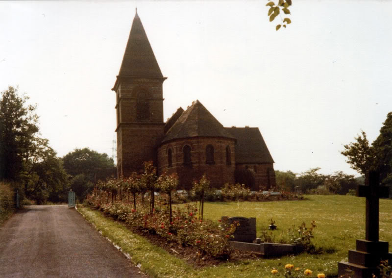
| Description | : | St Johns Church Lawley The Church of St John the Evangelist was designed by John Ladds in the Gothic style. It is of red and yellow brick with stone dressings and comprises a chancel with apse, north chapel (used since 1905 as a vestry), a south vestry (used as a boiler house), a southwest turret and spire and a nave with gallery and south porch. The single bell, made in 1865 was added in 1915. A red and white marble font stands at the southwest entrance dating from the church's inception. The original pump organ was replaced in 1970 with the present... Read More |
frequently asked questions (FAQ):
-
Where is St Johns Church?
St Johns Church is located at Lawley, Telford and Wrekin Unitary Authority ,Shropshire ,England.
-
St Johns Church cemetery's updated grave count on graveviews.com?
0 memorials
-
Where are the coordinates of the St Johns Church?
Latitude: 52.6751550
Longitude: -2.4932670
Nearby Cemetories:
1. Dawley Baptist Chapel Cemetery
Dawley, Telford and Wrekin Unitary Authority, England
Coordinate: 52.6745400, -2.4689600
2. St. Leonard's Churchyard
Dawley, Telford and Wrekin Unitary Authority, England
Coordinate: 52.6695331, -2.4609601
3. St. Luke's Churchyard
Doseley, Telford and Wrekin Unitary Authority, England
Coordinate: 52.6560410, -2.4775480
4. St. Mary the Virgin Churchyard
Ketley, Telford and Wrekin Unitary Authority, England
Coordinate: 52.6914797, -2.4701998
5. Red Lake Garden of rest
Telford, Telford and Wrekin Unitary Authority, England
Coordinate: 52.6928969, -2.4715920
6. St. Lawrence's Churchyard
Little Wenlock, Telford and Wrekin Unitary Authority, England
Coordinate: 52.6582070, -2.5234340
7. Holy Trinity Churchyard
Dawley, Telford and Wrekin Unitary Authority, England
Coordinate: 52.6551528, -2.4637860
8. Wellington Cemetery
Wellington, Telford and Wrekin Unitary Authority, England
Coordinate: 52.6958280, -2.5246020
9. Holy Trinity Churchyard
Oakengates, Telford and Wrekin Unitary Authority, England
Coordinate: 52.6925070, -2.4562980
10. All Saints Churchyard
Wellington, Telford and Wrekin Unitary Authority, England
Coordinate: 52.7020230, -2.5177440
11. Coalbrookdale Quaker Burial Ground
Coalbrookdale, Telford and Wrekin Unitary Authority, England
Coordinate: 52.6417080, -2.4952200
12. St Mary's & St Leonard's Church Burial Ground
Wombridge, Telford and Wrekin Unitary Authority, England
Coordinate: 52.7014856, -2.4585662
13. St James Churchyard
Stirchley, Telford and Wrekin Unitary Authority, England
Coordinate: 52.6575707, -2.4451542
14. St. Peters Churchyard
Telford and Wrekin Unitary Authority, England
Coordinate: 52.6871100, -2.4404680
15. Wombridge Cemetery
Oakengates, Telford and Wrekin Unitary Authority, England
Coordinate: 52.7023940, -2.4579990
16. Hadley Cemetery
Leegomery, Telford and Wrekin Unitary Authority, England
Coordinate: 52.7097110, -2.4893660
17. Holy Trinity Churchyard
Coalbrookdale, Telford and Wrekin Unitary Authority, England
Coordinate: 52.6375300, -2.4894000
18. Castle Green Cemetery
Ironbridge, Telford and Wrekin Unitary Authority, England
Coordinate: 52.6346434, -2.4851070
19. St George's Churchyard
Oakengates, Telford and Wrekin Unitary Authority, England
Coordinate: 52.6952150, -2.4321740
20. Wrockwardine Wood Methodist Graveyard
Wrockwardine, Telford and Wrekin Unitary Authority, England
Coordinate: 52.7076180, -2.4426530
21. Holy Trinity Churchyard
Buildwas, Shropshire Unitary Authority, England
Coordinate: 52.6393710, -2.5380180
22. Holy Trinity Church
Wrockwardine, Telford and Wrekin Unitary Authority, England
Coordinate: 52.7105800, -2.4476600
23. St. Luke's Churchyard
Ironbridge, Telford and Wrekin Unitary Authority, England
Coordinate: 52.6285830, -2.4851180
24. St. Peter's Churchyard
Wrockwardine, Telford and Wrekin Unitary Authority, England
Coordinate: 52.7047350, -2.5569500

