
| Memorials | : | 0 |
| Location | : | Haughley, Mid Suffolk District, England |
| Coordinate | : | 52.2215800, 0.9647260 |
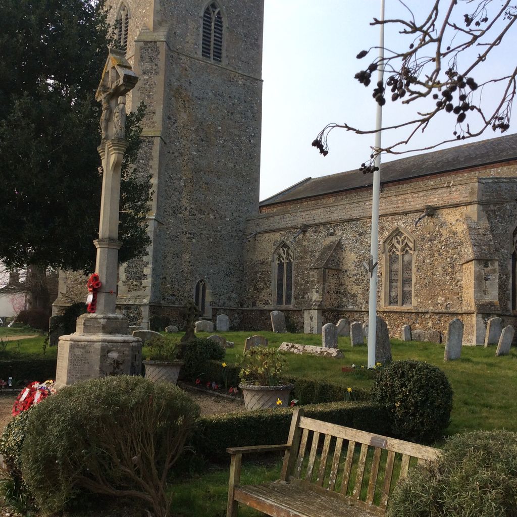
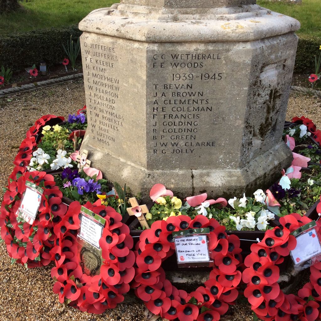
| Description | : | The church building dates back to the 12th century. The war memorial situated in front of the church was first erected in 1920 following the WWI but was replaced by a plain cross in 1947 when it was blown down in a gale. However, in 1995, the original work was found and restored, names re-inscribed and names of the fallen from WWII were also added. |
frequently asked questions (FAQ):
-
Where is St. Mary the Virgin's Church?
St. Mary the Virgin's Church is located at Duke Street Haughley, Mid Suffolk District ,Suffolk , IP14 3QTEngland.
-
St. Mary the Virgin's Church cemetery's updated grave count on graveviews.com?
0 memorials
-
Where are the coordinates of the St. Mary the Virgin's Church?
Latitude: 52.2215800
Longitude: 0.9647260
Nearby Cemetories:
1. St. Augustine's Church Burial Ground
Harleston, Mid Suffolk District, England
Coordinate: 52.2045920, 0.9526440
2. King Charles the Martyr Churchyard
Shelland, Mid Suffolk District, England
Coordinate: 52.2039070, 0.9307170
3. St John the Baptist Churchyard
Onehouse, Mid Suffolk District, England
Coordinate: 52.1956290, 0.9495420
4. Old Newton Cemetery
Old Newton, Mid Suffolk District, England
Coordinate: 52.2213520, 1.0127410
5. St. Mary's Churchyard
Old Newton, Mid Suffolk District, England
Coordinate: 52.2216380, 1.0143500
6. New Stowmarket Cemetery
Stowmarket, Mid Suffolk District, England
Coordinate: 52.1948100, 0.9890740
7. Old Stowmarket Cemetery
Stowmarket, Mid Suffolk District, England
Coordinate: 52.1948000, 0.9923500
8. Methodist Church Burial Ground
Elmswell, Mid Suffolk District, England
Coordinate: 52.2371320, 0.9097780
9. Saint Peter and Saint Mary Churchyard
Stowmarket, Mid Suffolk District, England
Coordinate: 52.1881820, 0.9967600
10. United Reformed Church
Stowmarket, Mid Suffolk District, England
Coordinate: 52.1869020, 0.9966670
11. St. Andrew's Churchyard
Great Finborough, Mid Suffolk District, England
Coordinate: 52.1829290, 0.9439440
12. St John the Divine Churchyard
Elmswell, Mid Suffolk District, England
Coordinate: 52.2350000, 0.9014815
13. Elmswell Cemetery
Elmswell, Mid Suffolk District, England
Coordinate: 52.2328720, 0.8992110
14. Stowupland Cemetery
Stowupland, Mid Suffolk District, England
Coordinate: 52.1987389, 1.0293667
15. Holy Trinity Churchyard
Stowupland, Mid Suffolk District, England
Coordinate: 52.1999210, 1.0306050
16. Saint Mary's Churchyard
Buxhall, Mid Suffolk District, England
Coordinate: 52.1803740, 0.9283610
17. Rattlesden Cemetery
Rattlesden, Mid Suffolk District, England
Coordinate: 52.1961530, 0.8947200
18. Saint Mary Churchyard
Bacton, Mid Suffolk District, England
Coordinate: 52.2647310, 1.0076540
19. St Nicholas Churchyard
Rattlesden, Mid Suffolk District, England
Coordinate: 52.1941810, 0.8926210
20. St Mary Churchyard
Combs, Mid Suffolk District, England
Coordinate: 52.1729800, 0.9979300
21. Combs Parish Cemetery
Combs, Mid Suffolk District, England
Coordinate: 52.1714740, 0.9960700
22. Rattlesden Baptist Church
Rattlesden, Mid Suffolk District, England
Coordinate: 52.1924020, 0.8885300
23. All Saints Churchyard
Great Ashfield, Mid Suffolk District, England
Coordinate: 52.2719990, 0.9234480
24. St Andrew Churchyard
Cotton, Mid Suffolk District, England
Coordinate: 52.2613810, 1.0322230