
| Memorials | : | 4 |
| Location | : | Oxford, City of Oxford, England |
| Phone | : | 441865552738 |
| Coordinate | : | 51.7796280, -1.2643940 |
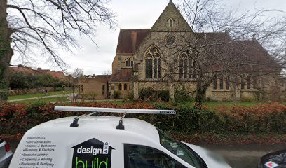
| Description | : | Anglican Church. 1909. Alfred Mardon Mowbray (1849-1915). Coursed ragstone with stone dressings with brick originally temporary west end. Early English style. PLAN: One bay aisled nave (four bays intended) with two further bays that open to wide and deep transepts to north and south. Deep chancel of three bays, same width as nave flanked by low arcaded aisles to Lady Chapel at southeast and two-level service area to southwest with vestry below and organ loft above reached by stair from north transept. ELEVATIONS: South: Projecting transept with steeply pitched roof and round quatrefoil above pair of large pointed arch windows each with... Read More |
frequently asked questions (FAQ):
-
Where is St Michael and All Angels Summertown?
St Michael and All Angels Summertown is located at 33 Lonsdale Road Oxford, City of Oxford ,Oxfordshire , OX 2 7ESEngland.
-
St Michael and All Angels Summertown cemetery's updated grave count on graveviews.com?
3 memorials
-
Where are the coordinates of the St Michael and All Angels Summertown?
Latitude: 51.7796280
Longitude: -1.2643940
Nearby Cemetories:
1. St. Peter Churchyard
Wolvercote, City of Oxford, England
Coordinate: 51.7848300, -1.2811100
2. Wolvercote Cemetery
Oxford, City of Oxford, England
Coordinate: 51.7913666, -1.2721500
3. St. Nicholas Churchyard
Old Marston, City of Oxford, England
Coordinate: 51.7761340, -1.2373130
4. St. Sepulchres Cemetery
Oxford, City of Oxford, England
Coordinate: 51.7611110, -1.2694440
5. Elsfield Road Cemetery
Old Marston, City of Oxford, England
Coordinate: 51.7752940, -1.2332640
6. St Paul's Oxford Cemetery
Oxford, City of Oxford, England
Coordinate: 51.7594590, -1.2648470
7. St Giles Churchyard
Oxford, City of Oxford, England
Coordinate: 51.7591660, -1.2605170
8. Saint Barnabas Church
Oxford, City of Oxford, England
Coordinate: 51.7579620, -1.2697600
9. Godstow Abbey Ruins
Oxford, City of Oxford, England
Coordinate: 51.7784060, -1.2998170
10. Saint Margaret of Antioch
City of Oxford, England
Coordinate: 51.7690340, -1.2975900
11. Mansfield College Chapel
Oxford, City of Oxford, England
Coordinate: 51.7576410, -1.2523340
12. Blackfriars
Oxford, City of Oxford, England
Coordinate: 51.7561210, -1.2602060
13. St Johns College
Oxford, City of Oxford, England
Coordinate: 51.7560820, -1.2589910
14. Wadham College Chapel
Oxford, City of Oxford, England
Coordinate: 51.7560700, -1.2540350
15. Martyrs' Memorial
Oxford, City of Oxford, England
Coordinate: 51.7550900, -1.2590100
16. Trinity College Chapel
Oxford, City of Oxford, England
Coordinate: 51.7552360, -1.2569620
17. Austin Friars Church
Oxford, City of Oxford, England
Coordinate: 51.7553710, -1.2541550
18. St. Mary Magdalene's Churchyard
Oxford, City of Oxford, England
Coordinate: 51.7546250, -1.2588340
19. Balliol College Chapel
Oxford, City of Oxford, England
Coordinate: 51.7547800, -1.2572240
20. Rewley Abbey
Oxford, City of Oxford, England
Coordinate: 51.7543810, -1.2675170
21. Saint Cross Church
Oxford, City of Oxford, England
Coordinate: 51.7561880, -1.2479120
22. St. Cross Churchyard
Holywell, City of Oxford, England
Coordinate: 51.7558380, -1.2479690
23. St. Michael at the North Gate Church
Oxford, City of Oxford, England
Coordinate: 51.7537210, -1.2583950
24. Exeter College Chapel
Oxford, City of Oxford, England
Coordinate: 51.7539460, -1.2561170