
| Memorials | : | 0 |
| Location | : | Great Doddington, Wellingborough Borough, England |
| Phone | : | 01933 226711 |
| Website | : | www.gdwebenefice.wordpress.com |
| Coordinate | : | 52.2747326, -0.7097420 |
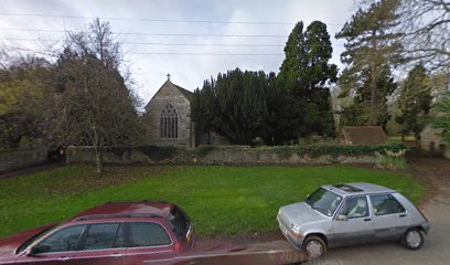
| Description | : | St. Nicholas’ Church dates from about 1100. It started life as a religious house and was home to several nuns and monks. The church was temporarily closed during the reign of King John. At that time bodies were buried in the woods and sermons were preached outside the main door! The building also housed the village school from 1823. There are many interesting features of the building. These include the original Priest’s Doorway on the north side of the chancel, the 17th century hour glass still in reach from the pulpit(!), a 15th century mural painting behind the lectern, and... Read More |
frequently asked questions (FAQ):
-
Where is St. Nicholas' Churchyard?
St. Nicholas' Churchyard is located at 1 Church Lane Great Doddington, Wellingborough Borough ,Northamptonshire , NN29 7TR England.
-
St. Nicholas' Churchyard cemetery's updated grave count on graveviews.com?
0 memorials
-
Where are the coordinates of the St. Nicholas' Churchyard?
Latitude: 52.2747326
Longitude: -0.7097420
Nearby Cemetories:
1. Nene Valley Crematorium
Wellingborough, Wellingborough Borough, England
Coordinate: 52.2827104, -0.6945270
2. Saint Mary Churchyard
Wilby, Wellingborough Borough, England
Coordinate: 52.2868890, -0.7309180
3. Doddington Road Cemetery
Wellingborough, Wellingborough Borough, England
Coordinate: 52.2942380, -0.6956600
4. Earls Barton Cemetery
Earls Barton, Wellingborough Borough, England
Coordinate: 52.2739600, -0.7468900
5. London Road Cemetery
Wellingborough, Wellingborough Borough, England
Coordinate: 52.2986000, -0.6878000
6. Wollaston
Wollaston, Wellingborough Borough, England
Coordinate: 52.2581088, -0.6726313
7. All Saints Churchyard
Earls Barton, Wellingborough Borough, England
Coordinate: 52.2650406, -0.7541093
8. All Hallows Churchyard
Wellingborough Borough, England
Coordinate: 52.3024740, -0.6937430
9. All Saints Churchyard
Wellingborough, Wellingborough Borough, England
Coordinate: 52.3010890, -0.6879730
10. St Rumwold's Churchyard
Strixton, Wellingborough Borough, England
Coordinate: 52.2456740, -0.6777530
11. St Mary Churchyard
Grendon, Wellingborough Borough, England
Coordinate: 52.2351630, -0.7145540
12. Irchester Cemetery
Irchester, Wellingborough Borough, England
Coordinate: 52.2848000, -0.6456000
13. Irchester Saint Katherine Churchyard
Irchester, Wellingborough Borough, England
Coordinate: 52.2843900, -0.6446900
14. All Saints Churchyard
Mears Ashby, Wellingborough Borough, England
Coordinate: 52.2916990, -0.7721170
15. St. Michael's Church
Farndish, Bedford Borough, England
Coordinate: 52.2638108, -0.6416839
16. St Mary the Virgin
Whiston, South Northamptonshire Borough, England
Coordinate: 52.2363400, -0.7538700
17. St. Mary Magdalene's Churchyard
Ecton, Wellingborough Borough, England
Coordinate: 52.2640177, -0.7874379
18. St. Leonard Churchyard
Hardwick, Wellingborough Borough, England
Coordinate: 52.3195551, -0.7533578
19. St. Mary Magdalene Churchyard
Castle Ashby, South Northamptonshire Borough, England
Coordinate: 52.2237000, -0.7371000
20. All Saints Churchyard
Great Harrowden, Wellingborough Borough, England
Coordinate: 52.3286800, -0.7096600
21. St Peter and St Paul Churchyard
Easton Maudit, Wellingborough Borough, England
Coordinate: 52.2204300, -0.7006700
22. St. Mary the Virgin Churchyard
Bozeat, Wellingborough Borough, England
Coordinate: 52.2235060, -0.6747470
23. St. Peter's Churchyard
Cogenhoe, South Northamptonshire Borough, England
Coordinate: 52.2413000, -0.7856000
24. Ss Peter and Paul Churchyard
Sywell, Wellingborough Borough, England
Coordinate: 52.2968890, -0.7965030