
| Memorials | : | 0 |
| Location | : | Farndish, Bedford Borough, England |
| Phone | : | 01223 324442 |
| Website | : | www.visitchurches.org.uk |
| Coordinate | : | 52.2638108, -0.6416839 |
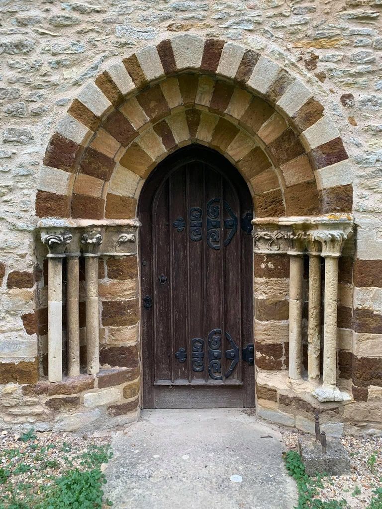
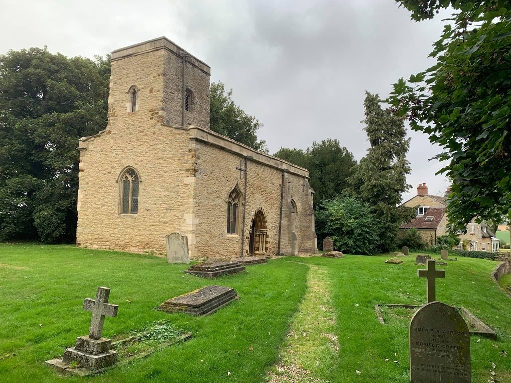
| Description | : | The village of Farndish is situated between Irchester, Wollaston and Podington. The church of St Michael and All Angels is no longer in use as a parish church and is in the care of The Churches Conservation Trust. The church is situated in the middle of the hamlet of Farndish in the north-west of Bedfordshire on the border of Northamptonshire. This tiny church was originally built in the late 12th century and has a great sense of peace and serenity. The church was restored in 1846 and declared redundant in 1970 before being taken on by the Churches Conservation Trust In... Read More |
frequently asked questions (FAQ):
-
Where is St. Michael's Church?
St. Michael's Church is located at Farndish, Bedford Borough ,Bedfordshire , NN29 7HUEngland.
-
St. Michael's Church cemetery's updated grave count on graveviews.com?
0 memorials
-
Where are the coordinates of the St. Michael's Church?
Latitude: 52.2638108
Longitude: -0.6416839
Nearby Cemetories:
1. St Mary the Virgin Churchyard
Podington, Bedford Borough, England
Coordinate: 52.2539100, -0.6220900
2. Wollaston
Wollaston, Wellingborough Borough, England
Coordinate: 52.2581088, -0.6726313
3. Irchester Saint Katherine Churchyard
Irchester, Wellingborough Borough, England
Coordinate: 52.2843900, -0.6446900
4. Irchester Cemetery
Irchester, Wellingborough Borough, England
Coordinate: 52.2848000, -0.6456000
5. St Lawrence Churchyard
Wymington, Bedford Borough, England
Coordinate: 52.2694310, -0.6017230
6. St Rumwold's Churchyard
Strixton, Wellingborough Borough, England
Coordinate: 52.2456740, -0.6777530
7. St Mary Churchyard
Rushden, East Northamptonshire Borough, England
Coordinate: 52.2885570, -0.5973860
8. Nene Valley Crematorium
Wellingborough, Wellingborough Borough, England
Coordinate: 52.2827104, -0.6945270
9. Newton Road Cemetery
Rushden, East Northamptonshire Borough, England
Coordinate: 52.2882140, -0.5859750
10. St. Nicholas' Churchyard
Great Doddington, Wellingborough Borough, England
Coordinate: 52.2747326, -0.7097420
11. London Road Cemetery
Wellingborough, Wellingborough Borough, England
Coordinate: 52.2986000, -0.6878000
12. Doddington Road Cemetery
Wellingborough, Wellingborough Borough, England
Coordinate: 52.2942380, -0.6956600
13. St. Mary the Virgin Churchyard
Bozeat, Wellingborough Borough, England
Coordinate: 52.2235060, -0.6747470
14. All Saints Churchyard
Wellingborough, Wellingborough Borough, England
Coordinate: 52.3010890, -0.6879730
15. All Hallows Churchyard
Wellingborough Borough, England
Coordinate: 52.3024740, -0.6937430
16. St. Mary the Virgin Churchyard
Higham Ferrers, East Northamptonshire Borough, England
Coordinate: 52.3065500, -0.5915240
17. St Mary Churchyard
Grendon, Wellingborough Borough, England
Coordinate: 52.2351630, -0.7145540
18. Higham Ferrers Cemetery
Higham Ferrers, East Northamptonshire Borough, England
Coordinate: 52.3084850, -0.5945270
19. New Irthlingborough Cemetery
Irthlingborough, East Northamptonshire Borough, England
Coordinate: 52.3178531, -0.6294229
20. All Saints Churchyard
Souldrop, Bedford Borough, England
Coordinate: 52.2433000, -0.5584000
21. St Peter and St Paul Churchyard
Easton Maudit, Wellingborough Borough, England
Coordinate: 52.2204300, -0.7006700
22. Saint Mary Churchyard
Wilby, Wellingborough Borough, England
Coordinate: 52.2868890, -0.7309180
23. All Saints Churchyard
Odell, Bedford Borough, England
Coordinate: 52.2114900, -0.5869800
24. Harrold United Reformed Church Cemetery
Harrold, Bedford Borough, England
Coordinate: 52.2021458, -0.6139397