
| Memorials | : | 0 |
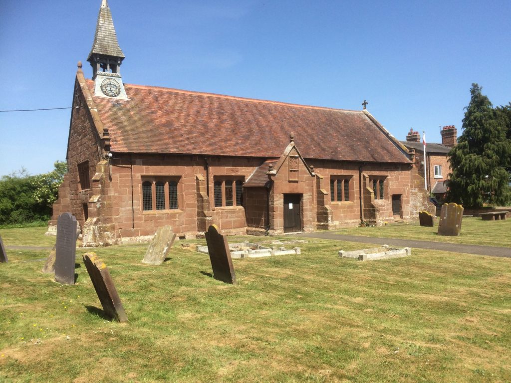
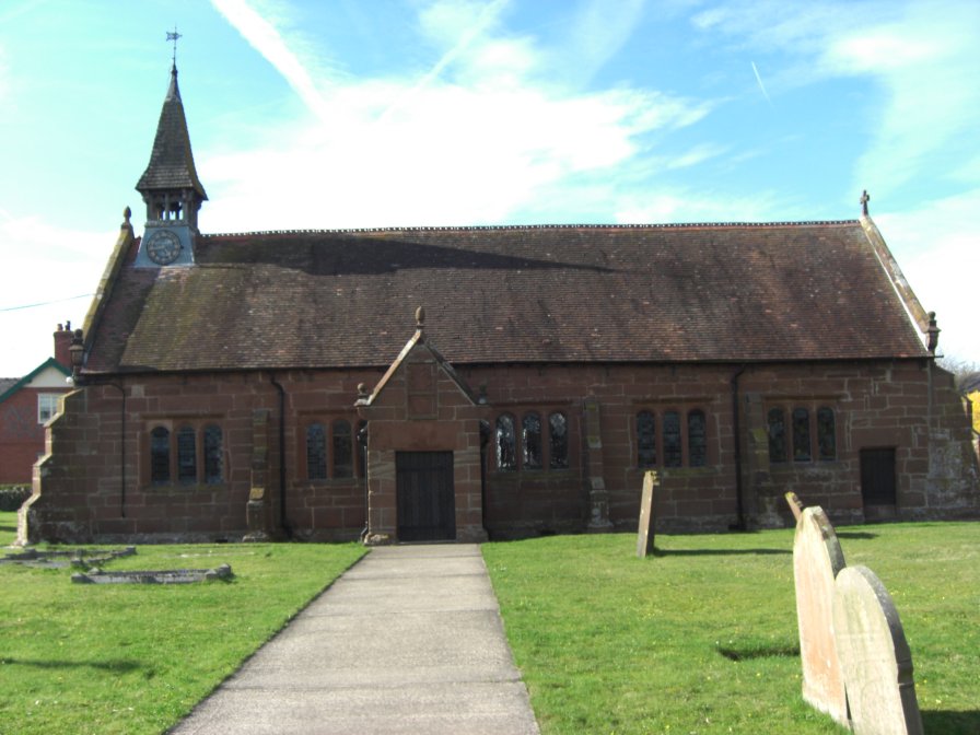
| Location | : | Hargrave, Cheshire West and Chester Unitary Authority, England |
| Coordinate | : | 53.1545450, -2.7710450 |
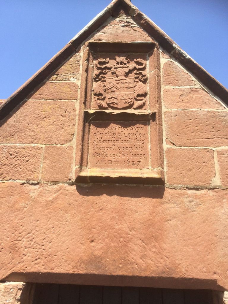
| Description | : | The building is Grade 2* listed and dates from 1627 when it was built as a school and chapel by a former resident of the village Thomas Moulson. He had moved to London where he became an MP and later Lord Mayor of London. His family coat of arms and a record of his founding the church are in the porch. In the late 1800's a lot of restoration was carried out and a vestry was added. Most of the original fittings were removed during the restoration but the baptismal font was saved. The parish... Read More |
frequently asked questions (FAQ):
-
Where is St. Peter's Churchyard?
St. Peter's Churchyard is located at Church Lane Hargrave, Cheshire West and Chester Unitary Authority ,Cheshire , CH3 7RNEngland.
-
St. Peter's Churchyard cemetery's updated grave count on graveviews.com?
0 memorials
-
Where are the coordinates of the St. Peter's Churchyard?
Latitude: 53.1545450
Longitude: -2.7710450
Nearby Cemetories:
1. St Peter Churchyard
Waverton, Cheshire West and Chester Unitary Authority, England
Coordinate: 53.1645900, -2.8065200
2. Huxley Jubilee Primitive Methodist Chapel
Huxley, Cheshire West and Chester Unitary Authority, England
Coordinate: 53.1480680, -2.7314010
3. St Alban's Churchyard
Tattenhall, Cheshire West and Chester Unitary Authority, England
Coordinate: 53.1217800, -2.7688900
4. St Peter's Churchyard
Duddon, Cheshire West and Chester Unitary Authority, England
Coordinate: 53.1762600, -2.7256400
5. All Saints Churchyard
Handley, Cheshire West and Chester Unitary Authority, England
Coordinate: 53.1153060, -2.7990430
6. St Andrew Churchyard
Tarvin, Cheshire West and Chester Unitary Authority, England
Coordinate: 53.1973170, -2.7620510
7. St Mary Churchyard
Bruera, Cheshire West and Chester Unitary Authority, England
Coordinate: 53.1390980, -2.8420290
8. St James Churchyard
Christleton, Cheshire West and Chester Unitary Authority, England
Coordinate: 53.1854400, -2.8382800
9. St. Bartholomew's Churchyard
Barrow, Cheshire West and Chester Unitary Authority, England
Coordinate: 53.2094380, -2.7957310
10. St. John the Divine Churchyard
Burwardsley, Cheshire West and Chester Unitary Authority, England
Coordinate: 53.1035280, -2.7251110
11. St. Helen's Parish Churchyard
Tarporley, Cheshire West and Chester Unitary Authority, England
Coordinate: 53.1580000, -2.6691300
12. Tarporley Baptist Chapel
Tarporley, Cheshire West and Chester Unitary Authority, England
Coordinate: 53.1560400, -2.6673900
13. St. John the Baptist Churchyard
Guilden Sutton, Cheshire West and Chester Unitary Authority, England
Coordinate: 53.2077400, -2.8263600
14. Harthill Chester Churchyard
Harthill, Cheshire West and Chester Unitary Authority, England
Coordinate: 53.0924840, -2.7469490
15. St Phillip Churchyard
Kelsall, Cheshire West and Chester Unitary Authority, England
Coordinate: 53.2080200, -2.7114100
16. Kelsall Methodist Churchyard
Kelsall, Cheshire West and Chester Unitary Authority, England
Coordinate: 53.2095380, -2.7148410
17. St. John The Baptist Churchyard
Aldford, Cheshire West and Chester Unitary Authority, England
Coordinate: 53.1285900, -2.8698900
18. St Mary the Virgin Churchyard
Eccleston, Cheshire West and Chester Unitary Authority, England
Coordinate: 53.1570100, -2.8792600
19. St Mary's Churchyard
Coddington, Cheshire West and Chester Unitary Authority, England
Coordinate: 53.0926800, -2.8184900
20. St. John the Evangelist Churchyard
Ashton, Cheshire West and Chester Unitary Authority, England
Coordinate: 53.2231800, -2.7394300
21. St Jude's Churchyard
Tilstone Fearnall, Cheshire West and Chester Unitary Authority, England
Coordinate: 53.1399078, -2.6502414
22. St. Peter's Churchyard
Plemstall, Cheshire West and Chester Unitary Authority, England
Coordinate: 53.2249000, -2.8144700
23. St Peter's Parish Church Plemstall
Mickle Trafford, Cheshire West and Chester Unitary Authority, England
Coordinate: 53.2249565, -2.8143278
24. Mickle Trafford Methodist Church Cemetery
Chester, Cheshire West and Chester Unitary Authority, England
Coordinate: 53.2210040, -2.8327861