
| Memorials | : | 5 |
| Location | : | Dunton, North Norfolk District, England |
| Phone | : | 01328862447 |
| Coordinate | : | 52.8375460, 0.7887910 |
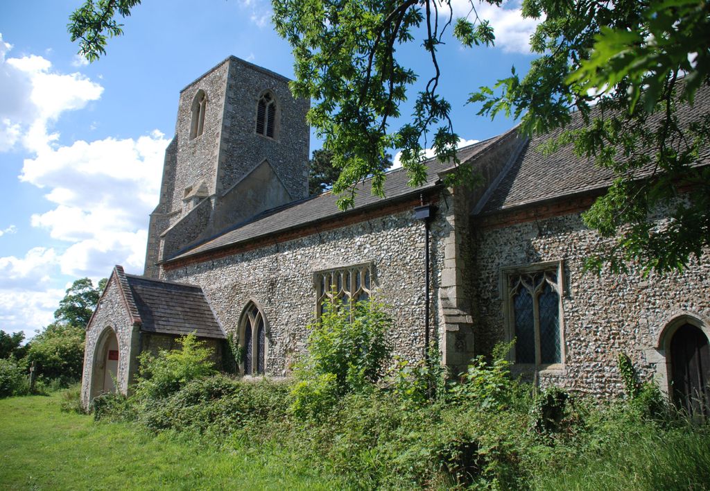
| Description | : | Probably Norman with a 14th Century chancel and nave window. The rest of the church is 15th century with a porch which was rebuilt in the 19th century. The rood loft is modern and can actually be accessed by the mediaeval rood stair. The stained glass in the east window commemorates Clement Felton, Chairman of the Guardians of the Poor of Walsingham Union. The nave south window has some splendid peacocks. The memorials range from one relating to Major William Case who fell at the Siege of Lucknow in 1857 to a ledger stone relating to a Matthew Lancaster who... Read More |
frequently asked questions (FAQ):
-
Where is St. Peter's Churchyard?
St. Peter's Churchyard is located at Dunton, North Norfolk District ,Norfolk , NR21 7PGEngland.
-
St. Peter's Churchyard cemetery's updated grave count on graveviews.com?
5 memorials
-
Where are the coordinates of the St. Peter's Churchyard?
Latitude: 52.8375460
Longitude: 0.7887910
Nearby Cemetories:
1. Fakenham Creake Road Cemetery
Fakenham, North Norfolk District, England
Coordinate: 52.8403170, 0.8348050
2. All Saint's Churchyard
Helhoughton, North Norfolk District, England
Coordinate: 52.8038639, 0.7713343
3. St Peter & St Paul Churchyard
Fakenham, North Norfolk District, England
Coordinate: 52.8308090, 0.8474920
4. Fakenham Cemetery
Fakenham, North Norfolk District, England
Coordinate: 52.8324060, 0.8500670
5. Assumption of the Blessed Virgin Mary Churchyard
Barsham, North Norfolk District, England
Coordinate: 52.8667710, 0.8283940
6. St Mary Churchyard
East Raynham, North Norfolk District, England
Coordinate: 52.7946530, 0.7864240
7. All Saints Churchyard
East Barsham, North Norfolk District, England
Coordinate: 52.8666620, 0.8459870
8. St. Mary's Churchyard
Syderstone, Kings Lynn and West Norfolk Borough, England
Coordinate: 52.8603000, 0.7214000
9. St Mary the Virgin Churchyard
Colkirk, Breckland Borough, England
Coordinate: 52.8021610, 0.8433730
10. All Saints Churchyard Waterden
South Creake, Kings Lynn and West Norfolk Borough, England
Coordinate: 52.8866500, 0.7997600
11. Saint Mary's Churchyard
East Rudham, Kings Lynn and West Norfolk Borough, England
Coordinate: 52.8210400, 0.7106100
12. All Saints Churchyard
Oxwick, Breckland Borough, England
Coordinate: 52.7917630, 0.8316080
13. All Saints Churchyard
North Barsham, North Norfolk District, England
Coordinate: 52.8777330, 0.8451480
14. St. Mary's Churchyard
South Creake, Kings Lynn and West Norfolk Borough, England
Coordinate: 52.8914540, 0.7565120
15. St. Peter's Churchyard
West Rudham, Kings Lynn and West Norfolk Borough, England
Coordinate: 52.8155500, 0.6984470
16. St Giles Churchyard
Barsham, North Norfolk District, England
Coordinate: 52.8813000, 0.8574300
17. St Mary Churchyard
North Creake, Kings Lynn and West Norfolk Borough, England
Coordinate: 52.9034150, 0.7565120
18. St Andrew Churchyard
Little Snoring, North Norfolk District, England
Coordinate: 52.8551400, 0.8990400
19. St Mary The Virgin Churchyard
Great Snoring, North Norfolk District, England
Coordinate: 52.8736000, 0.8914000
20. Saint Mary & All Saints Churchyard
Little Walsingham, North Norfolk District, England
Coordinate: 52.8910800, 0.8748300
21. Our Lady of Walsingham Chapel
Little Walsingham, North Norfolk District, England
Coordinate: 52.8936750, 0.8755360
22. St. Mary Churchyard
Bagthorpe, Kings Lynn and West Norfolk Borough, England
Coordinate: 52.8575650, 0.6657910
23. St. Martin’s Churchyard
Houghton, Kings Lynn and West Norfolk Borough, England
Coordinate: 52.8231250, 0.6605550
24. St. Andrew's Churchyard
Great Ryburgh, North Norfolk District, England
Coordinate: 52.8072980, 0.9094190