
| Memorials | : | 8 |
| Location | : | Lynsted, Swale Borough, England |
| Coordinate | : | 51.3150770, 0.7864080 |
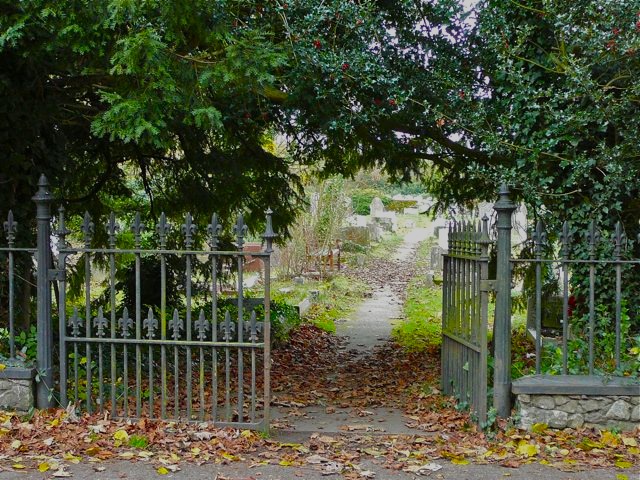
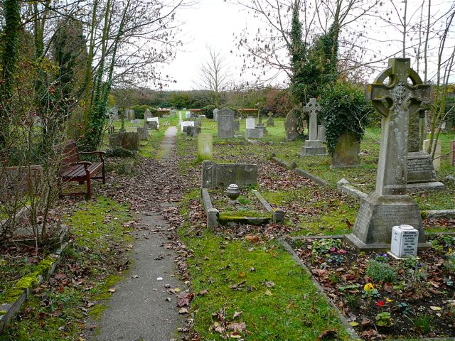
| Description | : | The New Churchyard is on the same side of The Street as the church of St Peter and St Paul, past the Black Lion public house and a short distance along the lane towards Teynham. The cemetery notice board had been vandalised at the time the photographs were taken. The oldest graves, dating from the very late nineteenth century, are at the east end, nearest to the gate; the extension to the west is still in use. There are seven war graves, from the First and Second World Wars. |
frequently asked questions (FAQ):
-
Where is St Peter and St Paul New Churchyard?
St Peter and St Paul New Churchyard is located at The Street Lynsted, Swale Borough ,Kent ,England.
-
St Peter and St Paul New Churchyard cemetery's updated grave count on graveviews.com?
8 memorials
-
Where are the coordinates of the St Peter and St Paul New Churchyard?
Latitude: 51.3150770
Longitude: 0.7864080
Nearby Cemetories:
1. St Peter and St Paul Churchyard
Lynsted, Swale Borough, England
Coordinate: 51.3138300, 0.7860890
2. St. Nicholas Churchyard
Rodmersham, Swale Borough, England
Coordinate: 51.3227780, 0.7627730
3. St. Laurence's Churchyard
Bapchild, Swale Borough, England
Coordinate: 51.3330520, 0.7655020
4. St Mary Churchyard
Norton, Swale Borough, England
Coordinate: 51.3149750, 0.8221900
5. St Giles Churchyard
Tonge, Swale Borough, England
Coordinate: 51.3424640, 0.7757790
6. The Beheading of St. John the Baptist Churchyard
Doddington, Swale Borough, England
Coordinate: 51.2843350, 0.7805830
7. St Mary Churchyard
Teynham, Swale Borough, England
Coordinate: 51.3377640, 0.8213570
8. St Peter and St Paul Churchyard
Newnham, Swale Borough, England
Coordinate: 51.2842590, 0.8006070
9. Sts Peter & Paul Churchyard Extension
Newnham, Swale Borough, England
Coordinate: 51.2840000, 0.8026500
10. Deerton Natural Burial Ground
Teynham, Swale Borough, England
Coordinate: 51.3344460, 0.8297850
11. Murston Cemetery
Sittingbourne, Swale Borough, England
Coordinate: 51.3424700, 0.7527100
12. Sittingbourne Cemetery
Sittingbourne, Swale Borough, England
Coordinate: 51.3345300, 0.7348000
13. St. Mary and the Holy Cross Churchyard
Milstead, Swale Borough, England
Coordinate: 51.2961020, 0.7288260
14. St John the Baptist Churchyard
Tunstall, Swale Borough, England
Coordinate: 51.3246010, 0.7196400
15. Holy Trinity Church
Sittingbourne, Swale Borough, England
Coordinate: 51.3416000, 0.7316000
16. St. Mary Churchyard
Eastling, Swale Borough, England
Coordinate: 51.2740700, 0.8155000
17. St Mary Churchyard
Luddenham, Swale Borough, England
Coordinate: 51.3324180, 0.8586720
18. Holy Trinity Churchyard
Milton Regis, Swale Borough, England
Coordinate: 51.3556700, 0.7401300
19. St Peter and St Paul Churchyard
Ospringe, Swale Borough, England
Coordinate: 51.3070220, 0.8690570
20. St. Margaret's Churchyard
Wichling, Maidstone Borough, England
Coordinate: 51.2682226, 0.7455862
21. St Dunstan Churchyard
Frinsted, Maidstone Borough, England
Coordinate: 51.2843300, 0.7112270
22. St. John the Baptist Churchyard
Bredgar, Swale Borough, England
Coordinate: 51.3109210, 0.6960930
23. St Peter and St Paul Churchyard
Borden, Swale Borough, England
Coordinate: 51.3347350, 0.7008350
24. St. Bartholomew's Churchyard
Bobbing, Swale Borough, England
Coordinate: 51.3537600, 0.7101420