
| Memorials | : | 21 |
| Location | : | Tonge, Swale Borough, England |
| Coordinate | : | 51.3424640, 0.7757790 |
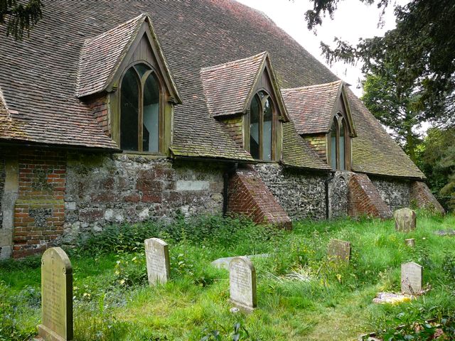
| Description | : | ST GILES CHURCH, TONGE, SWALE BOROUGH, KENT, ENGLAND. Church Road, Tonge. Post Code: ME10 2BL Tel: 01795 429360 Latitude: 51°20'32"N Longitude: 0°46'32"E Parish church. 12th and 14th century, Restored 16th and 17th century, and 1893 (£150). Flint, with red brick buttresses and chancel and plain tiled roofs. Condition: Poor. Slow decay; no solution agreed. Nave and aisles, south tower and south porch. Nave and aisles under one roof. West door with triple hollow chamfered surround, and large 14th century 3-light west window with intersecting and cusped tracery; brick corner buttresses. 19th century timber framed porch, with roll moulded and chamfered... Read More |
frequently asked questions (FAQ):
-
Where is St Giles Churchyard?
St Giles Churchyard is located at Tonge, Swale Borough ,Kent ,England.
-
St Giles Churchyard cemetery's updated grave count on graveviews.com?
21 memorials
-
Where are the coordinates of the St Giles Churchyard?
Latitude: 51.3424640
Longitude: 0.7757790
Nearby Cemetories:
1. St. Laurence's Churchyard
Bapchild, Swale Borough, England
Coordinate: 51.3330520, 0.7655020
2. Murston Cemetery
Sittingbourne, Swale Borough, England
Coordinate: 51.3424700, 0.7527100
3. St. Nicholas Churchyard
Rodmersham, Swale Borough, England
Coordinate: 51.3227780, 0.7627730
4. Holy Trinity Churchyard
Milton Regis, Swale Borough, England
Coordinate: 51.3556700, 0.7401300
5. Sittingbourne Cemetery
Sittingbourne, Swale Borough, England
Coordinate: 51.3345300, 0.7348000
6. Holy Trinity Church
Sittingbourne, Swale Borough, England
Coordinate: 51.3416000, 0.7316000
7. St Peter and St Paul New Churchyard
Lynsted, Swale Borough, England
Coordinate: 51.3150770, 0.7864080
8. St Mary Churchyard
Teynham, Swale Borough, England
Coordinate: 51.3377640, 0.8213570
9. St Peter and St Paul Churchyard
Lynsted, Swale Borough, England
Coordinate: 51.3138300, 0.7860890
10. Deerton Natural Burial Ground
Teynham, Swale Borough, England
Coordinate: 51.3344460, 0.8297850
11. St John the Baptist Churchyard
Tunstall, Swale Borough, England
Coordinate: 51.3246010, 0.7196400
12. St Mary Churchyard
Norton, Swale Borough, England
Coordinate: 51.3149750, 0.8221900
13. Garden of England Crematorium
Bobbing, Swale Borough, England
Coordinate: 51.3595330, 0.7179190
14. St. Bartholomew's Churchyard
Bobbing, Swale Borough, England
Coordinate: 51.3537600, 0.7101420
15. All Saints Churchyard
Iwade, Swale Borough, England
Coordinate: 51.3787920, 0.7306550
16. St Peter and St Paul Churchyard
Borden, Swale Borough, England
Coordinate: 51.3347350, 0.7008350
17. St Mary Churchyard
Luddenham, Swale Borough, England
Coordinate: 51.3324180, 0.8586720
18. St. Mary and the Holy Cross Churchyard
Milstead, Swale Borough, England
Coordinate: 51.2961020, 0.7288260
19. The Beheading of St. John the Baptist Churchyard
Doddington, Swale Borough, England
Coordinate: 51.2843350, 0.7805830
20. St. John the Baptist Churchyard
Bredgar, Swale Borough, England
Coordinate: 51.3109210, 0.6960930
21. St Peter and St Paul Churchyard
Newnham, Swale Borough, England
Coordinate: 51.2842590, 0.8006070
22. Sts Peter & Paul Churchyard Extension
Newnham, Swale Borough, England
Coordinate: 51.2840000, 0.8026500
23. St Mary the Virgin Churchyard
Newington, Swale Borough, England
Coordinate: 51.3567080, 0.6733120
24. St Peter's Churchyard
Oare, Swale Borough, England
Coordinate: 51.3335910, 0.8804350