
| Memorials | : | 0 |
| Location | : | Rodmell, Lewes District, England |
| Coordinate | : | 50.8384680, 0.0177350 |
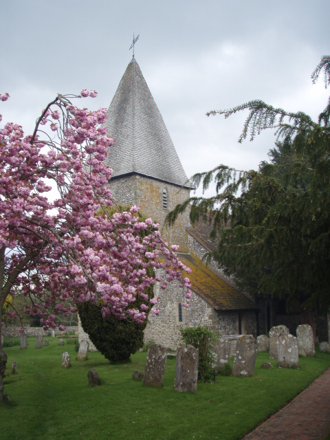
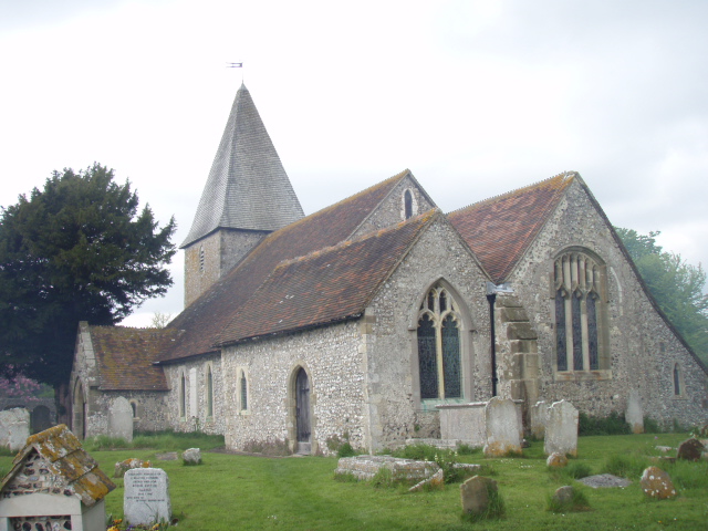
| Description | : | Rodmell is a small village and civil parish in the Lewes District of East Sussex, England. It is located three miles (4.8 km) south-west of Lewes, on the Lewes to Newhaven road and is situated by the west banks of the River Ouse. The village is served by Southease railway station, opened in 1906. The Prime Meridian passes just to the west of Rodmell. It has an early Norman church, dedicated to St. Peter, whose font is believed to be Saxon, predating the building itself. |
frequently asked questions (FAQ):
-
Where is St Peters Churchyard?
St Peters Churchyard is located at Rodmell, Lewes District ,East Sussex , BN7 3HFEngland.
-
St Peters Churchyard cemetery's updated grave count on graveviews.com?
0 memorials
-
Where are the coordinates of the St Peters Churchyard?
Latitude: 50.8384680
Longitude: 0.0177350
Nearby Cemetories:
1. Monk's House Grounds
Rodmell, Lewes District, England
Coordinate: 50.8387500, 0.0165280
2. Southease Churchyard
Southease, Lewes District, England
Coordinate: 50.8294960, 0.0191830
3. St Nicholas Churchyard
Iford, Lewes District, England
Coordinate: 50.8483860, -0.0007940
4. St Andrew Churchyard
Beddingham, Lewes District, England
Coordinate: 50.8524971, 0.0516700
5. St Laurence Churchyard
Telscombe, Lewes District, England
Coordinate: 50.8128300, -0.0064050
6. St Marys Churchyard
Tarring Neville, Lewes District, England
Coordinate: 50.8155480, 0.0485160
7. Lewes Priory
Lewes, Lewes District, England
Coordinate: 50.8681240, 0.0083870
8. St. John's Churchyard
Piddinghoe, Lewes District, England
Coordinate: 50.8094870, 0.0355770
9. Southover Parish Church of St John the Baptist
Lewes, Lewes District, England
Coordinate: 50.8690840, 0.0062220
10. St Pancras Churchyard
Kingston, Lewes District, England
Coordinate: 50.8562900, -0.0245250
11. All Saints Churchyard
Lewes, Lewes District, England
Coordinate: 50.8723630, 0.0135060
12. Saint Michael's Churchyard
Lewes, Lewes District, England
Coordinate: 50.8722440, 0.0070970
13. Lewes Cemetery
Lewes, Lewes District, England
Coordinate: 50.8707680, -0.0017370
14. St. Anne's Churchyard
Lewes, Lewes District, England
Coordinate: 50.8723390, 0.0017700
15. St Thomas A Becket Churchyard
Lewes, Lewes District, England
Coordinate: 50.8744780, 0.0187450
16. Lewes Goal
Lewes, Lewes District, England
Coordinate: 50.8756155, 0.0115680
17. HMP Lewes
Lewes District, England
Coordinate: 50.8729973, -0.0048753
18. St. John Sub Castro Churchyard
Lewes, Lewes District, England
Coordinate: 50.8759800, 0.0093800
19. Newhaven Cemetery
Newhaven, Lewes District, England
Coordinate: 50.8005470, 0.0367040
20. St. Mary the Virgin Churchyard
Glynde, Lewes District, England
Coordinate: 50.8646000, 0.0683000
21. Saint Michael The Archangel Churchyard
South Malling, Lewes District, England
Coordinate: 50.8811470, 0.0069090
22. South Heighton Cemetery
South Heighton, Lewes District, England
Coordinate: 50.8032730, 0.0616380
23. St. Peter's Churchyard
West Firle, Lewes District, England
Coordinate: 50.8448639, 0.0884910
24. Catholic Church of the Immaculate Conception
Brighton, Brighton and Hove Unitary Authority, England
Coordinate: 50.7929140, -0.0005080