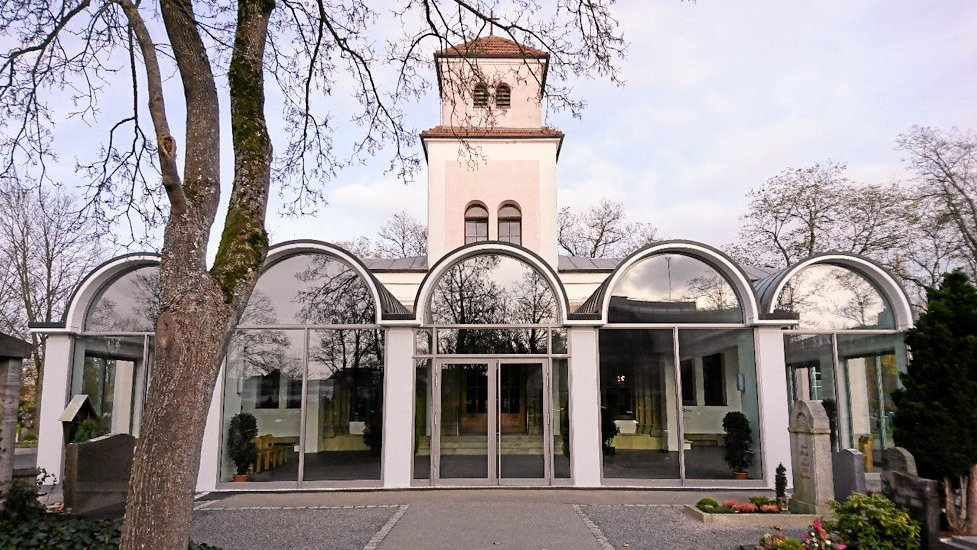
| Memorials | : | 0 |
| Location | : | Weiden, Stadtkreis Weiden in der Oberpfalz, Germany |
| Coordinate | : | 49.6830060, 12.1674850 |
| Description | : | A town administered as an independent district ("Kreisfrei"), Weiden in der Oberpfalz is situated in the northern part of the Bavarian district Upper Palatinate, 100 km east of Nuremberg and 35 km west of the Czech Republic. It is divided into 15 sub-districts. AKA Städtischer Friedhof Weiden. The Stadtfriedhof (Municipal Cemetery) in Weiden is the largest of the cemeteries in this city. It has about 8200 standard burial plots and another 500 plots for urns. Municipal Cemeteries in Weiden: Waldfriedhof Weiden Stadtfriedhof Weiden Städtischer Friedhof Rothenstadt Congregational Cemeteries in Weiden: Katholischer Friedhof Rothenstadt (Catholic) Evangelischer Friedhof Rothenstadt (Lutheran) Katholischer Friedhof Neunkirchen (Catholic) Please note that the graves in Germany are... Read More |
frequently asked questions (FAQ):
-
Where is Stadtfriedhof Weiden?
Stadtfriedhof Weiden is located at Gabelsberger Strasse Weiden, Stadtkreis Weiden in der Oberpfalz ,Bavaria (Bayern) , 92637Germany.
-
Stadtfriedhof Weiden cemetery's updated grave count on graveviews.com?
0 memorials
-
Where are the coordinates of the Stadtfriedhof Weiden?
Latitude: 49.6830060
Longitude: 12.1674850
Nearby Cemetories:
1. Stadtfriedhof Weiden
Mantel, Landkreis Neustadt an der Waldnaab, Germany
Coordinate: 49.6832931, 12.1679767
2. Waldfriedhof Weiden in der Oberpfalz
Weiden, Stadtkreis Weiden in der Oberpfalz, Germany
Coordinate: 49.6893160, 12.1231430
3. Friedhof Altenstadt
Neustadt an der Waldnaab, Landkreis Neustadt an der Waldnaab, Germany
Coordinate: 49.7209529, 12.1614447
4. Waldthurn Cemetery
Waldthurn, Landkreis Neustadt an der Waldnaab, Germany
Coordinate: 49.6733979, 12.3310412
5. Friedhof Windischeschenbach
Windischeschenbach, Landkreis Neustadt an der Waldnaab, Germany
Coordinate: 49.8028010, 12.1589940
6. Friedhof Vohenstrauss
Vohenstrauss, Landkreis Neustadt an der Waldnaab, Germany
Coordinate: 49.6257373, 12.3443936
7. Flossenbürg Concentration Camp Memorial
Flossenburg, Landkreis Neustadt an der Waldnaab, Germany
Coordinate: 49.7355560, 12.3558330
8. Friedhof
Pressath, Landkreis Neustadt an der Waldnaab, Germany
Coordinate: 49.7686420, 11.9397076
9. Friedhofsverwaltung Grafenwöhr (Friedhofsamt)
Grafenwohr, Landkreis Neustadt an der Waldnaab, Germany
Coordinate: 49.7180378, 11.9071789
10. St. Peter und Paul Kirche
Moosbach, Landkreis Neustadt an der Waldnaab, Germany
Coordinate: 49.5916339, 12.4089772
11. Friedhof Bärnau
Bärnau, Landkreis Tirschenreuth, Germany
Coordinate: 49.8099010, 12.4323170
12. St. Martin
Gebenbach, Landkreis Amberg-Sulzbach, Germany
Coordinate: 49.5393458, 11.8984362
13. Friedhof Wiesau
Wiesau, Landkreis Tirschenreuth, Germany
Coordinate: 49.9092600, 12.1874900
14. Friedhof Pappenberg
Pappenberg, Landkreis Neustadt an der Waldnaab, Germany
Coordinate: 49.7050674, 11.8138521
15. St. Agidius
Vilseck, Landkreis Amberg-Sulzbach, Germany
Coordinate: 49.6104380, 11.8073220
16. Friedhof Vilseck
Vilseck, Landkreis Amberg-Sulzbach, Germany
Coordinate: 49.6079927, 11.8054734
17. Aschach
Aschach, Landkreis Amberg-Sulzbach, Germany
Coordinate: 49.4704600, 11.9045560
18. Friedhof Paulsdorf
Paulsdorf, Landkreis Amberg-Sulzbach, Germany
Coordinate: 49.4406664, 11.9424126
19. Friedhof Neusorg
Neusorg, Landkreis Tirschenreuth, Germany
Coordinate: 49.9346850, 11.9643760
20. Friedhof Ammersricht
Amberg, Stadtkreis Amberg, Germany
Coordinate: 49.4692816, 11.8618769
21. Friedhof Kirchenthumbach
Kirchenthumbach, Landkreis Neustadt an der Waldnaab, Germany
Coordinate: 49.7519720, 11.7274320
22. Friedhof Waldershof
Waldershof, Landkreis Tirschenreuth, Germany
Coordinate: 49.9787780, 12.0608750
23. Basilika St. Martin
Amberg, Stadtkreis Amberg, Germany
Coordinate: 49.4449440, 11.8577500
24. Friedhof Mitterauerbach
Mitterauerbach, Landkreis Schwandorf, Germany
Coordinate: 49.3785323, 12.2711369


