
| Memorials | : | 0 |
| Location | : | Stordal, Stordal kommune, Norway |
| Coordinate | : | 62.3839700, 7.0143400 |
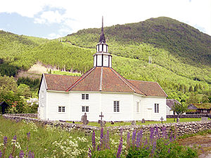
| Description | : | Stordal gamle Kirke (Old Stordal Church) was built in 1789 to replace an earlier stave church on the site and is located about 1 kilometer (0.62 miles) east of Stordal nye Kirke (New Stordal Church). |
frequently asked questions (FAQ):
-
Where is Stordal Gamle Kirke?
Stordal Gamle Kirke is located at Stordal, Stordal kommune ,Møre og Romsdal fylke ,Norway.
-
Stordal Gamle Kirke cemetery's updated grave count on graveviews.com?
0 memorials
-
Where are the coordinates of the Stordal Gamle Kirke?
Latitude: 62.3839700
Longitude: 7.0143400
Nearby Cemetories:
1. Stordal Nye Kirke
Stordal, Stordal kommune, Norway
Coordinate: 62.3826000, 7.0008000
2. Ødegård
Stranda kommune, Norway
Coordinate: 62.3166064, 6.9346576
3. Ødegaard Cemetery
Stranda, Stranda kommune, Norway
Coordinate: 62.3162170, 6.9345400
4. Orskog Church Cemetery
Ørskog kommune, Norway
Coordinate: 62.4789930, 6.8135780
5. Noddal Cemetery
Eidsdal, Norddal kommune, Norway
Coordinate: 62.2559322, 7.2371636
6. Skodje Cemetery
Skodje, Skodje kommune, Norway
Coordinate: 62.5060180, 6.6966760
7. Sykkylven
Sykkylven kommune, Norway
Coordinate: 62.3942400, 6.5821620
8. Vestnes Church Cemetery
Vestnes, Vestnes kommune, Norway
Coordinate: 62.6277670, 7.0842080
9. Vatne
Vatne, Haram kommune, Norway
Coordinate: 62.5548723, 6.6081402
10. Hatlehol Cemetery
Spjelkavik, Ålesund kommune, Norway
Coordinate: 62.4355200, 6.3925400
11. Geiranger Church Cemetery
Stranda kommune, Norway
Coordinate: 62.0988477, 7.2071905
12. Hjørundfjord
Orsta, Ørsta kommune, Norway
Coordinate: 62.2096960, 6.4736210
13. Sekken kyrkje
Molde kommune, Norway
Coordinate: 62.6606700, 7.3823400
14. Ringstad Cemetery
Brattvag, Haram kommune, Norway
Coordinate: 62.5932008, 6.4663320
15. Indre Sula Cemetery
Fiskarstranda, Sula kommune, Norway
Coordinate: 62.4284000, 6.3010000
16. Sandnes Cemetery
Afarnes, Rauma kommune, Norway
Coordinate: 62.6313000, 7.5198540
17. Brattvaag Cemetery
Haram, Haram kommune, Norway
Coordinate: 62.6021880, 6.4397580
18. Brattvåg
Brattvag, Haram kommune, Norway
Coordinate: 62.6021964, 6.4393782
19. Otrøy Cemetery
Midsund, Midsund kommune, Norway
Coordinate: 62.6993844, 6.7079435
20. Grytten Churchyard
Andalsnes, Rauma kommune, Norway
Coordinate: 62.5526010, 7.6725270
21. Bjørke
Bjorke, Ørsta kommune, Norway
Coordinate: 62.1070530, 6.5564190
22. Aandalsnes Church Cemetery
Andalsnes, Rauma kommune, Norway
Coordinate: 62.5649430, 7.6819810
23. Molde Nedre Cemetery
Molde kommune, Norway
Coordinate: 62.7388170, 7.1544200
24. Slotsvika Cemetery
Ålesund kommune, Norway
Coordinate: 62.4920809, 6.2702817