
| Memorials | : | 120 |
| Location | : | Blue Creek, Adams County, USA |
| Coordinate | : | 38.7169100, -83.3159000 |
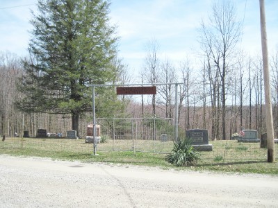
| Description | : | The cemetery is on the west side of Sunshine Ridge Road (Township Road 202A) about 0.5 miles east of its intersection with Lower Twin Creek Road (County Road 4). The cemetery is located in Green Township, Adams County, Ohio, and is # 30 (Sunshine Ridge Cemetery / Sunshine Church Cemetery) in “Ohio Cemeteries 1803-2003”, compiled by the Ohio Genealogical Society. The cemetery is registered with the Ohio Division of Real Estate and Professional Licensing (ODRE) as Sunshine Ridge Cemetery with registration license number CRC.2015005842. The U.S. Geological Survey (USGS) Geographic Names Information System (GNIS) feature ID for the... Read More |
frequently asked questions (FAQ):
-
Where is Sunshine Ridge Cemetery?
Sunshine Ridge Cemetery is located at Sunshine Ridge Road (Township Road 202A) Blue Creek, Adams County ,Ohio , 45616USA.
-
Sunshine Ridge Cemetery cemetery's updated grave count on graveviews.com?
117 memorials
-
Where are the coordinates of the Sunshine Ridge Cemetery?
Latitude: 38.7169100
Longitude: -83.3159000
Nearby Cemetories:
1. Stepp Church Cemetery
Blue Creek, Adams County, USA
Coordinate: 38.7168999, -83.3031006
2. Evans Family Cemetery
Blue Creek, Adams County, USA
Coordinate: 38.7297800, -83.3294500
3. Hubbard Cemetery
Blue Creek, Adams County, USA
Coordinate: 38.7391730, -83.3400362
4. High Hill Cemetery
Jefferson Township, Adams County, USA
Coordinate: 38.7193985, -83.3546982
5. Manchester Family Cemetery
Blue Creek, Adams County, USA
Coordinate: 38.7229520, -83.3570690
6. Lower Twin Cemetery
Blue Creek, Adams County, USA
Coordinate: 38.6743100, -83.3027600
7. Brown Cemetery
Nile Township, Scioto County, USA
Coordinate: 38.7124620, -83.2575970
8. Rocky Fork Cemetery
Nile Township, Scioto County, USA
Coordinate: 38.7226800, -83.2576890
9. McGraw Cemetery
Nile Township, Scioto County, USA
Coordinate: 38.7122248, -83.2575254
10. Blue Creek Hill Cemetery
Blue Creek, Adams County, USA
Coordinate: 38.7623180, -83.3061050
11. Armstrong Cemetery
Blue Creek, Adams County, USA
Coordinate: 38.7304100, -83.3775500
12. Wintersteen Cemetery
Blue Creek, Adams County, USA
Coordinate: 38.7612100, -83.2827500
13. Drake Cemetery
Blue Creek, Adams County, USA
Coordinate: 38.7677994, -83.3257980
14. Cox Cemetery
Blue Creek, Adams County, USA
Coordinate: 38.7257200, -83.3867800
15. River Family Cemetery
Green Township, Adams County, USA
Coordinate: 38.6613500, -83.2931700
16. Hazelbaker Cemetery
Blue Creek, Adams County, USA
Coordinate: 38.7734517, -83.3388611
17. Puntenney Cemetery
Green Township, Adams County, USA
Coordinate: 38.7038994, -83.3914032
18. Dead Man Hollow Burial Site
Nile Township, Scioto County, USA
Coordinate: 38.6937625, -83.2427030
19. Paul Lewis Cemetery
Blue Creek, Adams County, USA
Coordinate: 38.7755435, -83.3513432
20. Copas Cemetery
Blue Creek, Adams County, USA
Coordinate: 38.7717018, -83.3649979
21. Berea Chapel Cemetery
Brush Creek Township, Scioto County, USA
Coordinate: 38.7689000, -83.2613300
22. Point Cemetery
Stout, Adams County, USA
Coordinate: 38.6727982, -83.3814011
23. Moores Chapel Cemetery
Jefferson, Adams County, USA
Coordinate: 38.7850000, -83.3140000
24. Hamilton Cemetery
Lynx, Adams County, USA
Coordinate: 38.7530000, -83.3950000