
| Memorials | : | 0 |
| Location | : | Blue Creek, Adams County, USA |
| Coordinate | : | 38.7612100, -83.2827500 |
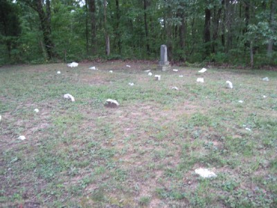
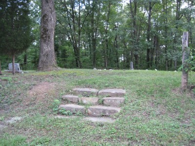
| Description | : | The cemetery is located on the west side of Mount Unger Road (Township Road 160B) about 200 feet northwest of its intersection with Wren Road (Township Road 164). The cemetery is located in Jefferson Township, Adams County, Ohio, and is # 13144 (Wintersteen Cemetery / Winterstein Cemetery) in “Ohio Cemeteries 1803-2003”, compiled by the Ohio Genealogical Society. The cemetery is registered with the Ohio Division of Real Estate and Professional Licensing (ODRE) as Mt Armenia Cemetery with registration license number CGR.0000982291. The U.S. Geological Survey (USGS) Geographic Names Information System (GNIS) feature ID for the cemetery is 1048013... Read More |
frequently asked questions (FAQ):
-
Where is Wintersteen Cemetery?
Wintersteen Cemetery is located at Mount Unger Road (Township Road 160B) Blue Creek, Adams County ,Ohio , 45657USA.
-
Wintersteen Cemetery cemetery's updated grave count on graveviews.com?
0 memorials
-
Where are the coordinates of the Wintersteen Cemetery?
Latitude: 38.7612100
Longitude: -83.2827500
Nearby Cemetories:
1. Blue Creek Hill Cemetery
Blue Creek, Adams County, USA
Coordinate: 38.7623180, -83.3061050
2. Berea Chapel Cemetery
Brush Creek Township, Scioto County, USA
Coordinate: 38.7689000, -83.2613300
3. Mount Unger Cemetery
Blue Creek, Adams County, USA
Coordinate: 38.7856200, -83.2848000
4. Setty-Ode Cemetery
Blue Creek, Adams County, USA
Coordinate: 38.7857700, -83.2871100
5. Moores Chapel Cemetery
Jefferson, Adams County, USA
Coordinate: 38.7850000, -83.3140000
6. Drake Cemetery
Blue Creek, Adams County, USA
Coordinate: 38.7677994, -83.3257980
7. Rocky Fork Cemetery
Nile Township, Scioto County, USA
Coordinate: 38.7226800, -83.2576890
8. Hazelbaker Cemetery
Blue Creek, Adams County, USA
Coordinate: 38.7734517, -83.3388611
9. Stepp Church Cemetery
Blue Creek, Adams County, USA
Coordinate: 38.7168999, -83.3031006
10. Evans Family Cemetery
Blue Creek, Adams County, USA
Coordinate: 38.7297800, -83.3294500
11. Hubbard Cemetery
Blue Creek, Adams County, USA
Coordinate: 38.7391730, -83.3400362
12. Sunshine Ridge Cemetery
Blue Creek, Adams County, USA
Coordinate: 38.7169100, -83.3159000
13. Brown Cemetery
Nile Township, Scioto County, USA
Coordinate: 38.7124620, -83.2575970
14. McGraw Cemetery
Nile Township, Scioto County, USA
Coordinate: 38.7122248, -83.2575254
15. Paul Lewis Cemetery
Blue Creek, Adams County, USA
Coordinate: 38.7755435, -83.3513432
16. Oppy Cemetery
Brush Creek Township, Scioto County, USA
Coordinate: 38.7989006, -83.2266998
17. Copas Cemetery
Blue Creek, Adams County, USA
Coordinate: 38.7717018, -83.3649979
18. Cassel Cemetery
Jefferson Township, Adams County, USA
Coordinate: 38.7980995, -83.3522034
19. Holt Cemetery
Portsmouth, Scioto County, USA
Coordinate: 38.7452700, -83.2010080
20. Manchester Family Cemetery
Blue Creek, Adams County, USA
Coordinate: 38.7229520, -83.3570690
21. High Hill Cemetery
Jefferson Township, Adams County, USA
Coordinate: 38.7193985, -83.3546982
22. Parker Cemetery
Otway, Scioto County, USA
Coordinate: 38.7949982, -83.1999969
23. Moon Cemetery
Brush Creek Township, Scioto County, USA
Coordinate: 38.7943993, -83.1992035
24. Koenig Cemetery
Otway, Scioto County, USA
Coordinate: 38.8203000, -83.2272000