
| Memorials | : | 95 |
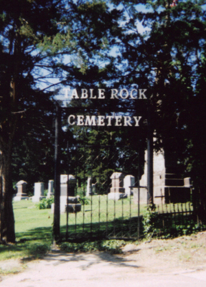
| Location | : | Table Rock, Pawnee County, USA |
| Coordinate | : | 40.1791400, -96.1037400 |
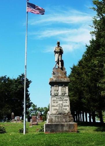
| Description | : | The Table Rock Cemetery is located on the west edge of the Village of Table Rock and is bounded by Pennsylvania and Luzerne Streets and 9th and 10th Streets. An imposing 23-foot high Civil War monument in the northeast corner of the cemetery was dedicated in 1903 by the Grand Army of the Republic and its auxiliary, the Woman’s Relief Corps. There are 60 Civil War veterans known to be buried in the cemetery, including several in unmarked graves; most settled in Table Rock after the Civil War. The Table Rock Cemetery Association was established in 1882, but the... Read More |
frequently asked questions (FAQ):
-
Where is Table Rock Cemetery?
Table Rock Cemetery is located at Table Rock, Pawnee County ,Nebraska ,USA.
-
Table Rock Cemetery cemetery's updated grave count on graveviews.com?
92 memorials
-
Where are the coordinates of the Table Rock Cemetery?
Latitude: 40.1791400
Longitude: -96.1037400
Nearby Cemetories:
1. Saint Johns Cemetery
Table Rock, Pawnee County, USA
Coordinate: 40.2148000, -96.0657000
2. Clear Creek Cemetery
Table Rock, Pawnee County, USA
Coordinate: 40.2193985, -96.1391983
3. East Amish Cemetery
Table Rock, Pawnee County, USA
Coordinate: 40.1310000, -96.0854000
4. Beranek Cemetery
Table Rock, Pawnee County, USA
Coordinate: 40.2042007, -96.1607971
5. Bohemian Cemetery
Table Rock, Pawnee County, USA
Coordinate: 40.1786003, -96.0374985
6. Pawnee City Cemetery
Pawnee City, Pawnee County, USA
Coordinate: 40.1109009, -96.1608810
7. Dry Branch Pioneer Cemetery
Richardson County, USA
Coordinate: 40.1292000, -96.0100021
8. Saint Anthonys Cemetery
Steinauer, Pawnee County, USA
Coordinate: 40.2075005, -96.2189026
9. Saint Peters Lutheran Church Cemetery
Steinauer, Pawnee County, USA
Coordinate: 40.2555000, -96.1801000
10. Longbranch Cemetery
Humboldt, Richardson County, USA
Coordinate: 40.1996000, -95.9740000
11. Bohemian Cemetery
Richardson County, USA
Coordinate: 40.1175003, -95.9955978
12. Standerford Cemetery
Humboldt, Richardson County, USA
Coordinate: 40.2110000, -95.9656000
13. Humboldt Cemetery
Humboldt, Richardson County, USA
Coordinate: 40.1610985, -95.9578018
14. Saint James Lutheran Cemetery
Nemaha County, USA
Coordinate: 40.2757500, -96.0161500
15. Mount Zion Cemetery
Nemaha County, USA
Coordinate: 40.2761002, -96.0113983
16. Mount Hope Cemetery
Elk Creek, Johnson County, USA
Coordinate: 40.2976000, -96.1406000
17. Salems Cemetery
Steinauer, Pawnee County, USA
Coordinate: 40.2166000, -96.2555000
18. Evergreen Cemetery
Pawnee County, USA
Coordinate: 40.0485992, -96.1417007
19. Trinity Lutheran Cemetery
Nemaha County, USA
Coordinate: 40.3058014, -96.0093994
20. Rinne Cemetery
Pawnee County, USA
Coordinate: 40.2472000, -96.2742004
21. Grandview Cemetery
Elk Creek, Johnson County, USA
Coordinate: 40.3274994, -96.1042023
22. Prairie Star Pioneer Cemetery
Du Bois, Pawnee County, USA
Coordinate: 40.0293000, -96.1041000
23. Pleasant Valley Cemetery
Pawnee County, USA
Coordinate: 40.0299988, -96.1554794
24. Lynchburg Cemetery
Humboldt, Richardson County, USA
Coordinate: 40.1306000, -95.9068985