
| Memorials | : | 1 |
| Location | : | Homewood, Masterton District, New Zealand |
| Coordinate | : | -41.1717200, 175.9813100 |
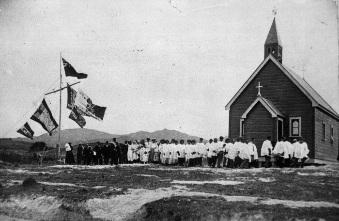
| Description | : | The Church of the Seven Rules of Jehovah sits on a little hill beside the Homewood Road. at Okautete, Homewood |
frequently asked questions (FAQ):
-
Where is Taupare Urupā?
Taupare Urupā is located at Homewood Road, Homewood, Masterton District ,Wellington ,New Zealand.
-
Taupare Urupā cemetery's updated grave count on graveviews.com?
1 memorials
-
Where are the coordinates of the Taupare Urupā?
Latitude: -41.1717200
Longitude: 175.9813100
Nearby Cemetories:
1. Waipoapoa Urupa
Hastings, Hastings District, New Zealand
Coordinate: -41.0696050, 175.6604650
2. Waipopo Urupā
Masterton, Masterton District, New Zealand
Coordinate: -41.0696370, 175.6604430
3. Gladstone Church Cemetery
Gladstone, Carterton District, New Zealand
Coordinate: -41.0883600, 175.6432100
4. Hamuera Urupā
Masterton District, New Zealand
Coordinate: -41.0374980, 175.6611940
5. Hurunui-o-rangi
Masterton, Masterton District, New Zealand
Coordinate: -41.0709670, 175.6200720
6. Ahi pane pane Urupā
Masterton, Masterton District, New Zealand
Coordinate: -40.9524060, 175.6902370
7. Tinui Cemetery
Masterton, Masterton District, New Zealand
Coordinate: -40.8714040, 176.0976860
8. Te Ahitainga Urupā
Masterton, Masterton District, New Zealand
Coordinate: -40.9393000, 175.7030750
9. Riverside Cemetery
Masterton, Masterton District, New Zealand
Coordinate: -40.9621550, 175.6722690
10. Archer Street Cemetery
Masterton, Masterton District, New Zealand
Coordinate: -40.9538900, 175.6683800
11. Church of St Francis of Assisi
Bideford, Masterton District, New Zealand
Coordinate: -40.8592400, 175.8714600
12. Masterton War Memorial
Masterton, Masterton District, New Zealand
Coordinate: -40.9501290, 175.6648800
13. Castlepoint Cemetery
Masterton, Masterton District, New Zealand
Coordinate: -40.8972060, 176.2189360
14. Oates Family Cemetery
Carterton, Carterton District, New Zealand
Coordinate: -41.0453670, 175.5683580
15. Akura Urupā
Masterton, Masterton District, New Zealand
Coordinate: -40.9314120, 175.6349090
16. Clareville Cemetery
Clareville, Carterton District, New Zealand
Coordinate: -40.9981070, 175.5459540
17. Papawai Urupā
Greytown, South Wairarapa District, New Zealand
Coordinate: -41.0985090, 175.4892270
18. Te Uru o Tane Urupā
Greytown, South Wairarapa District, New Zealand
Coordinate: -41.0570790, 175.4947740
19. Martinborough Cemetery
Martinborough, South Wairarapa District, New Zealand
Coordinate: -41.2158720, 175.4722330
20. Waihenga Cemetery
Martinborough, South Wairarapa District, New Zealand
Coordinate: -41.2176230, 175.4528540
21. Scandinavian Camp Cemetery
Kopuaranga, Masterton District, New Zealand
Coordinate: -40.8345650, 175.6643220
22. Greytown Cemetery
Greytown, South Wairarapa District, New Zealand
Coordinate: -41.0920470, 175.4401160
23. Mauriceville West Cemetery
Mauriceville West, Masterton District, New Zealand
Coordinate: -40.7670300, 175.6799680
24. Saint Francis Lutheran Churchyard
Mauriceville West, Masterton District, New Zealand
Coordinate: -40.7652900, 175.6834400