
| Memorials | : | 8 |
| Location | : | Redhill, Telford and Wrekin Unitary Authority, England |
| Coordinate | : | 52.6950750, -2.3988090 |
frequently asked questions (FAQ):
-
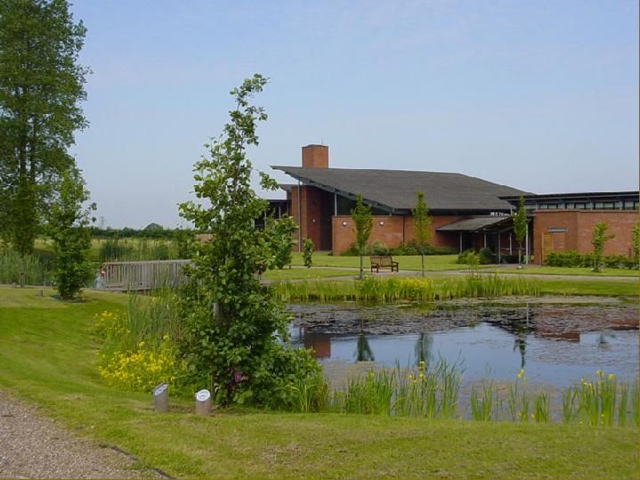
Where is Telford Crematorium?
Telford Crematorium is located at Woodhouse Lane Redhill, Telford and Wrekin Unitary Authority ,Shropshire , TF2 9NJEngland.
-
Telford Crematorium cemetery's updated grave count on graveviews.com?
8 memorials
-
Where are the coordinates of the Telford Crematorium?
Latitude: 52.6950750
Longitude: -2.3988090
Nearby Cemetories:
1. St George's Churchyard
Oakengates, Telford and Wrekin Unitary Authority, England
Coordinate: 52.6952150, -2.4321740
2. St. Peters Churchyard
Telford and Wrekin Unitary Authority, England
Coordinate: 52.6871100, -2.4404680
3. St. Matthew's Churchyard
Donnington Wood, Telford and Wrekin Unitary Authority, England
Coordinate: 52.7148135, -2.4308853
4. Wrockwardine Wood Methodist Graveyard
Wrockwardine, Telford and Wrekin Unitary Authority, England
Coordinate: 52.7076180, -2.4426530
5. Lilleshall Abbey
Lilleshall, Telford and Wrekin Unitary Authority, England
Coordinate: 52.7247000, -2.3898000
6. Holy Trinity Church
Wrockwardine, Telford and Wrekin Unitary Authority, England
Coordinate: 52.7105800, -2.4476600
7. Holy Trinity Churchyard
Oakengates, Telford and Wrekin Unitary Authority, England
Coordinate: 52.6925070, -2.4562980
8. Wombridge Cemetery
Oakengates, Telford and Wrekin Unitary Authority, England
Coordinate: 52.7023940, -2.4579990
9. St Mary's & St Leonard's Church Burial Ground
Wombridge, Telford and Wrekin Unitary Authority, England
Coordinate: 52.7014856, -2.4585662
10. St Michael and All Angels Churchyard
Lilleshall, Telford and Wrekin Unitary Authority, England
Coordinate: 52.7345610, -2.4032770
11. St. Mary the Virgin Churchyard
Ketley, Telford and Wrekin Unitary Authority, England
Coordinate: 52.6914797, -2.4701998
12. Red Lake Garden of rest
Telford, Telford and Wrekin Unitary Authority, England
Coordinate: 52.6928969, -2.4715920
13. St. Leonard's Churchyard
Dawley, Telford and Wrekin Unitary Authority, England
Coordinate: 52.6695331, -2.4609601
14. St James Churchyard
Stirchley, Telford and Wrekin Unitary Authority, England
Coordinate: 52.6575707, -2.4451542
15. Dawley Baptist Chapel Cemetery
Dawley, Telford and Wrekin Unitary Authority, England
Coordinate: 52.6745400, -2.4689600
16. Woodcote Parish Church
Woodcote, Telford and Wrekin Unitary Authority, England
Coordinate: 52.7358330, -2.3456640
17. Holy Trinity Churchyard
Dawley, Telford and Wrekin Unitary Authority, England
Coordinate: 52.6551528, -2.4637860
18. Hadley Cemetery
Leegomery, Telford and Wrekin Unitary Authority, England
Coordinate: 52.7097110, -2.4893660
19. St Johns Church
Lawley, Telford and Wrekin Unitary Authority, England
Coordinate: 52.6751550, -2.4932670
20. St. Luke's Churchyard
Doseley, Telford and Wrekin Unitary Authority, England
Coordinate: 52.6560410, -2.4775480
21. St Andrews Churchyard
Church Aston, Telford and Wrekin Unitary Authority, England
Coordinate: 52.7577930, -2.3815770
22. St Andrew Church
Weston-under-Lizard, South Staffordshire Borough, England
Coordinate: 52.6932000, -2.2883000
23. Talbot Chapel
Longford, Telford and Wrekin Unitary Authority, England
Coordinate: 52.7627400, -2.4081500
24. St. Michael's Churchyard
Madeley, Telford and Wrekin Unitary Authority, England
Coordinate: 52.6337300, -2.4503010