
| Memorials | : | 0 |
| Location | : | Stewart Island, Southland District, New Zealand |
| Coordinate | : | -46.9249600, 168.1922400 |
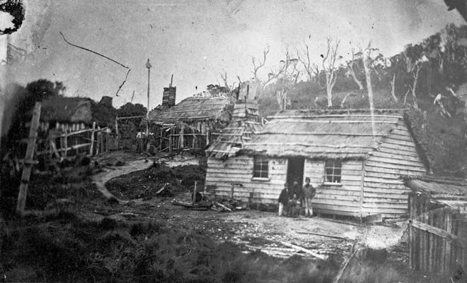
| Description | : | This "cemetery" consists of five different burial areas on the small peninsular of the outer southern edge of Paterson Inlet. In times past people did live here in small wooden whares (basic wooden planked cabin homes) with thatched rooves, the latter likely made of flax. Most burials here are Maori or early foreign Whalers and Sealers who had married into local Maori families, and their descendants, who lived on the Neck. |
frequently asked questions (FAQ):
-
Where is The Neck?
The Neck is located at Stewart Island, Southland District ,Southland ,New Zealand.
-
The Neck cemetery's updated grave count on graveviews.com?
0 memorials
-
Where are the coordinates of the The Neck?
Latitude: -46.9249600
Longitude: 168.1922400
Nearby Cemetories:
1. Braggs Bay Cemetery
Stewart Island, Southland District, New Zealand
Coordinate: -46.8896680, 168.1397690
2. Halfmoon Bay Cemetery
Stewart Island, Southland District, New Zealand
Coordinate: -46.8947480, 168.1248950
3. Horseshoe Bay Cemetery
Stewart Island, Southland District, New Zealand
Coordinate: -46.8814467, 168.1334396
4. Ruapuke Island Cemetery
Southland District, New Zealand
Coordinate: -46.7881040, 168.5048690
5. Bluff Cemetery
Bluff, Invercargill City, New Zealand
Coordinate: -46.6017310, 168.3248670
6. Captain Stirling Grave
Bluff, Invercargill City, New Zealand
Coordinate: -46.6016466, 168.3691108
7. Green Point Cemetery
Bluff, Invercargill City, New Zealand
Coordinate: -46.5739350, 168.3006450
8. Te Hau Mutunga Urupā
Invercargill, Invercargill City, New Zealand
Coordinate: -46.4288704, 168.4148361
9. South Cape, Rakiura National Park Lone Graves
Stewart Island, Southland District, New Zealand
Coordinate: -47.2667316, 167.5999384
10. Southland Crematorium
Invercargill, Invercargill City, New Zealand
Coordinate: -46.4109100, 168.3961330
11. Eastern Cemetery
Invercargill, Invercargill City, New Zealand
Coordinate: -46.4070770, 168.3961480
12. Holy Trinity Anglican Church
Invercargill, Invercargill City, New Zealand
Coordinate: -46.3984736, 168.3660057
13. Tararua Acre
Otara, Southland District, New Zealand
Coordinate: -46.6551940, 168.8762500
14. All Saints Anglican Church
Invercargill, Invercargill City, New Zealand
Coordinate: -46.3906042, 168.3476728
15. Fortrose Cemetery
Fortrose, Southland District, New Zealand
Coordinate: -46.5694400, 168.8088500
16. Saint Johns Cemetery
Invercargill, Invercargill City, New Zealand
Coordinate: -46.3748600, 168.3431480
17. Wallacetown New Cemetery
Wallacetown, Southland District, New Zealand
Coordinate: -46.3374900, 168.2835700
18. Wallacetown Old Cemetery
Wallacetown, Southland District, New Zealand
Coordinate: -46.3321840, 168.2861670
19. Colac Bay Cemetery
Colac Bay, Southland District, New Zealand
Coordinate: -46.3679806, 167.8798528
20. Riverton Cemetery
Riverton, Southland District, New Zealand
Coordinate: -46.3316900, 168.0215500
21. Wakapatu Cemetery
Wakapatu, Southland District, New Zealand
Coordinate: -46.3806050, 167.8060970
22. Woodlands Cemetery
Woodlands, Southland District, New Zealand
Coordinate: -46.3568800, 168.5463770
23. Ryal Bush
Ryal Bush, Southland District, New Zealand
Coordinate: -46.2836700, 168.3256000
24. Quarry Hills Cemetery
Quarry Hills, Southland District, New Zealand
Coordinate: -46.5433100, 169.0398300