
| Memorials | : | 0 |
| Location | : | Eclectic, Elmore County, USA |
| Coordinate | : | 32.6792330, -86.0232830 |
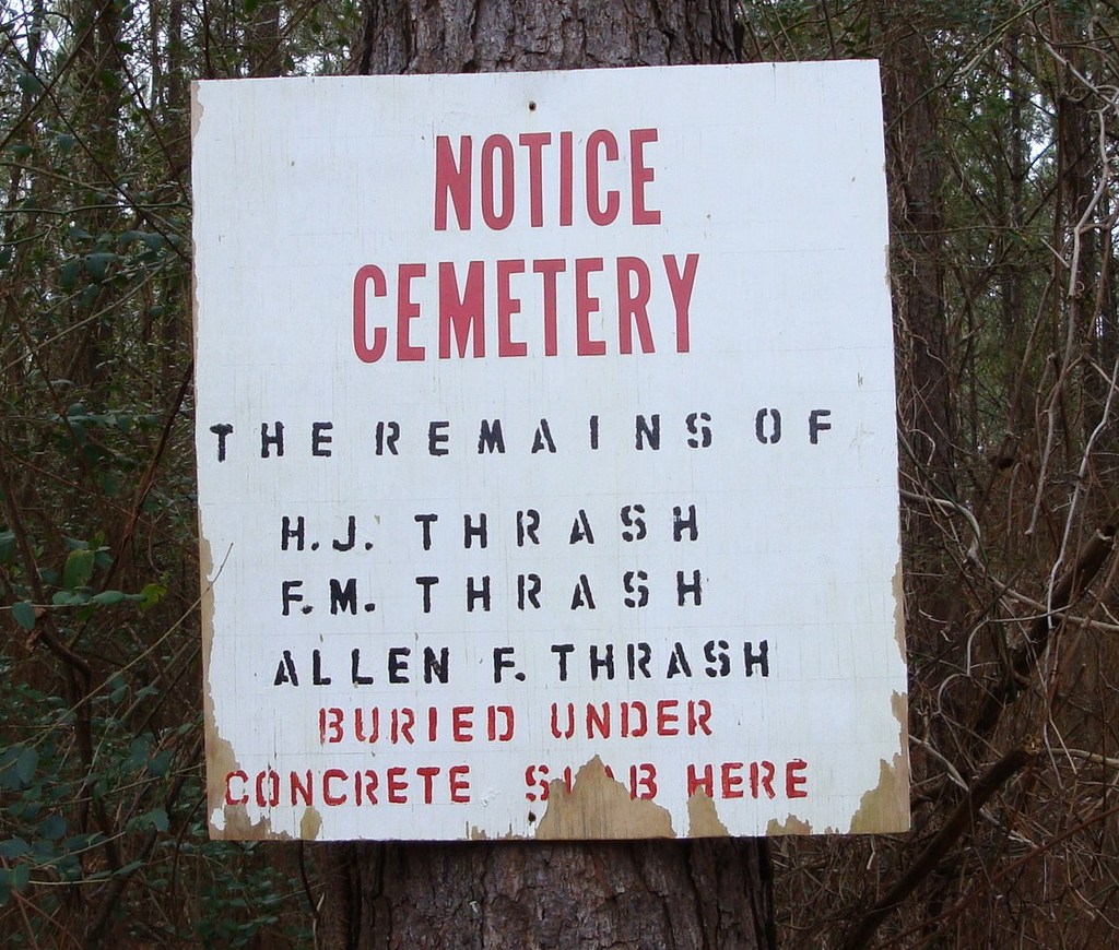
| Description | : | The Thrash Family Cemetery is the final resting place of the Thrash Family who were some of the first settler's who come into Coosa County from Chambers County and were awarded Land Warrent's of two parcel's of land (Approx. 40 acres in each parcel) Hilliard Jiles Thrash acquired a total of 1600 acres of land in the Cotton area of Coosa County AL.(Later Elmore County AL.) |
frequently asked questions (FAQ):
-
Where is Thrash Family Cemetery?
Thrash Family Cemetery is located at Hwy 63 North Eclectic, Elmore County ,Alabama , 36024USA.
-
Thrash Family Cemetery cemetery's updated grave count on graveviews.com?
0 memorials
-
Where are the coordinates of the Thrash Family Cemetery?
Latitude: 32.6792330
Longitude: -86.0232830
Nearby Cemetories:
1. Thrash Cemetery
Elmore County, USA
Coordinate: 32.6800003, -86.0199966
2. Cotton Cemetery
Cotton, Elmore County, USA
Coordinate: 32.6843987, -86.0194016
3. Warren-Kent Cemetery
Cotton, Elmore County, USA
Coordinate: 32.6871330, -86.0215670
4. Warren Cemetery
Eclectic, Elmore County, USA
Coordinate: 32.6741486, -86.0087204
5. Mount Hebron Church of Christ Cemetery
Jordan, Elmore County, USA
Coordinate: 32.6996670, -86.0273670
6. Mount Hebron East Baptist Church Cemetery
Falkner, Elmore County, USA
Coordinate: 32.6990471, -86.0305099
7. Mount Gilead Cemetery
Eclectic, Elmore County, USA
Coordinate: 32.7039986, -86.0243988
8. Watson Chapel Congregational Church Cemetery
Red Hill, Elmore County, USA
Coordinate: 32.6737170, -85.9842170
9. Union United Methodist Church Cemetery
Eclectic, Elmore County, USA
Coordinate: 32.6598170, -86.0582830
10. Pleasant Grove Cemetery
Eclectic, Elmore County, USA
Coordinate: 32.6395988, -86.0224991
11. Watson Chapel Cemetery
Red Hill, Elmore County, USA
Coordinate: 32.6819000, -85.9760971
12. Bullard Cemetery
Eclectic, Elmore County, USA
Coordinate: 32.6469002, -86.0513992
13. Halls Chapel Cemetery
Falkner, Elmore County, USA
Coordinate: 32.6957436, -86.0703354
14. Old Harmony Church Cemetery
Elmore County, USA
Coordinate: 32.7346992, -86.0121994
15. Benson-Bethel United Methodist Church Cemetery
Kowaliga, Elmore County, USA
Coordinate: 32.7165900, -85.9714500
16. Darden Cemetery
Eclectic, Elmore County, USA
Coordinate: 32.7292100, -85.9834650
17. New Prospect Cemetery
Eclectic, Elmore County, USA
Coordinate: 32.7288100, -85.9826400
18. Shiloh Missionary Baptist Church Cemetery
Kowaliga, Elmore County, USA
Coordinate: 32.7175800, -85.9680800
19. Old Union Cemetery
Central, Elmore County, USA
Coordinate: 32.6995087, -86.0931396
20. Central Baptist Church Cemetery
Central, Elmore County, USA
Coordinate: 32.6841011, -86.0988617
21. Pruitt - Pogue Cemetery
Eclectic, Elmore County, USA
Coordinate: 32.6214867, -86.0562057
22. Chana Creek Primitive Baptist Church Cemetery
Kent, Elmore County, USA
Coordinate: 32.6197014, -85.9894028
23. Refuge Cemetery
Red Hill, Elmore County, USA
Coordinate: 32.6842995, -85.9439011
24. Hornsby Cemetery at Red Hill
Tallassee, Elmore County, USA
Coordinate: 32.6854040, -85.9434510