
| Memorials | : | 0 |
| Location | : | Germantown, Montgomery County, USA |
| Coordinate | : | 39.1635010, -77.2833310 |
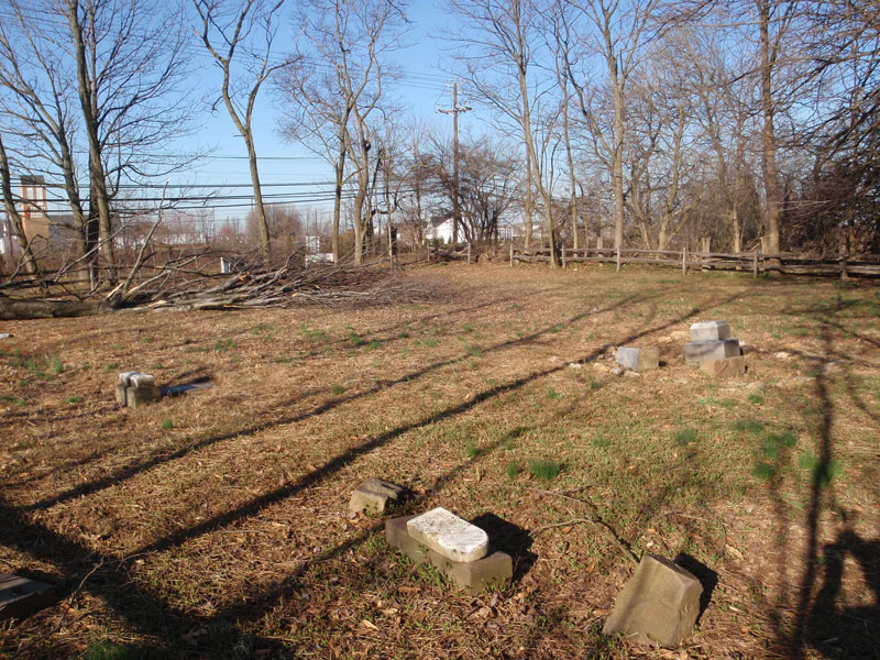
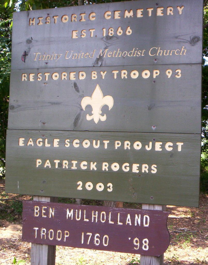
| Description | : | Historic Cemetery Established 1866 Originally Restored by Ben Mulholland Eagle Scout Troop 1760 in 1985. Original transcription and photos The land for this cemetery was donated back in 1872 by Solomon and Eleanor Leaman for the purpose of a cemetery for Trinity Methodist Church. For many years prior to the mid 1980s, the cemetery was neglected. Boy Scout Troop 1097 and their families spent over 500 hours cleaning and beautifing the little cemetery. They made it into a park like setting with benches.(1984-85). The Phillips Family for many years took care of the little cemetery for many years also. The cemetery was right... Read More |
frequently asked questions (FAQ):
-
Where is Trinity United Methodist Church Historic Cemetery?
Trinity United Methodist Church Historic Cemetery is located at Corner of Clopper Rd. & Germantown Rd. (118) Germantown, Montgomery County ,Maryland , 20874USA.
-
Trinity United Methodist Church Historic Cemetery cemetery's updated grave count on graveviews.com?
0 memorials
-
Where are the coordinates of the Trinity United Methodist Church Historic Cemetery?
Latitude: 39.1635010
Longitude: -77.2833310

Nearby Cemetories:
1. Magers-Mobley-Arnold Cemetery
Germantown, Montgomery County, USA
Coordinate: 39.1620000, -77.2779500
2. Musser Cemetery
Germantown, Montgomery County, USA
Coordinate: 39.1572200, -77.2660700
3. Germantown Baptist Church Cemetery
Germantown, Montgomery County, USA
Coordinate: 39.1456300, -77.2898800
4. Asbury United Methodist Cemetery
Germantown, Montgomery County, USA
Coordinate: 39.1418991, -77.2975006
5. Boyds Presbyterian Church Cemetery
Boyds, Montgomery County, USA
Coordinate: 39.1819000, -77.3155975
6. Waters Family Cemetery
Germantown, Montgomery County, USA
Coordinate: 39.1939600, -77.2715400
7. Saint Marks United Methodist Church Cemetery
Boyds, Montgomery County, USA
Coordinate: 39.1776200, -77.3203200
8. Saint Rose of Lima Cemetery
Gaithersburg, Montgomery County, USA
Coordinate: 39.1501400, -77.2432700
9. Waters Slave Cemetery
Germantown, Montgomery County, USA
Coordinate: 39.1966660, -77.2690180
10. Ricketts Family Cemetery
Middlebrook, Montgomery County, USA
Coordinate: 39.1675179, -77.2363281
11. Waters Family Cemetery
Germantown, Montgomery County, USA
Coordinate: 39.2006830, -77.2689060
12. Button Farm Slavery Burials
Germantown, Montgomery County, USA
Coordinate: 39.1283456, -77.3118924
13. Neelsville Presbyterian Church Cemetery
Germantown, Montgomery County, USA
Coordinate: 39.1955986, -77.2435989
14. Gott Family Farm - The Fertile Plains
Bucklodge, Montgomery County, USA
Coordinate: 39.1614100, -77.3408300
15. Dawson Family Cemetery
Dawsonville, Montgomery County, USA
Coordinate: 39.1376330, -77.3307140
16. Waters Family Cemetery
Germantown, Montgomery County, USA
Coordinate: 39.2063550, -77.2565030
17. Howes Family Cemetery
Germantown, Montgomery County, USA
Coordinate: 39.1803110, -77.2232180
18. Open Door MCC Memorial Garden
Boyds, Montgomery County, USA
Coordinate: 39.1991425, -77.3277588
19. Shaw Family Cemetery
Boyds, Montgomery County, USA
Coordinate: 39.2166250, -77.2821990
20. Pleasant Hills Cemetery
Darnestown, Montgomery County, USA
Coordinate: 39.1098340, -77.3033990
21. Mount of Olives Church Cemetery
Gaithersburg, Montgomery County, USA
Coordinate: 39.1140785, -77.2447891
22. Darne Family Cemetery (Defunct)
Darnestown, Montgomery County, USA
Coordinate: 39.1033520, -77.2909020
23. Darnestown Presbyterian Church Cemetery
Darnestown, Montgomery County, USA
Coordinate: 39.1029400, -77.2860400
24. All Souls Cemetery
Germantown, Montgomery County, USA
Coordinate: 39.2099900, -77.2328500