
| Memorials | : | 0 |
| Location | : | Springville, St. Clair County, USA |
| Coordinate | : | 33.7507840, -86.4924000 |
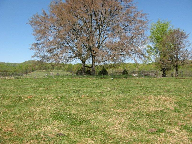
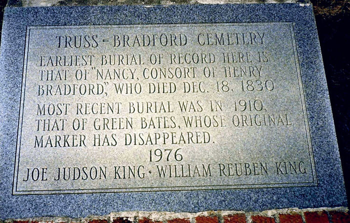
| Description | : | Truss/Bradford Cemetery is located 3 miles south of Springville,Al. on U.S. 11 behind large blue building on right side of highway. The cemetery is on private land owned by Steve and Ellen House. The House Family has a gate to cemetery for access. Descendant of families that are interred are welcome to enter. |
frequently asked questions (FAQ):
-
Where is Truss-Bradford Cemetery?
Truss-Bradford Cemetery is located at 5790 US 11 South Springville, St. Clair County ,Alabama , 35146USA.
-
Truss-Bradford Cemetery cemetery's updated grave count on graveviews.com?
0 memorials
-
Where are the coordinates of the Truss-Bradford Cemetery?
Latitude: 33.7507840
Longitude: -86.4924000
Nearby Cemetories:
1. Fuller Cemetery
Springville, St. Clair County, USA
Coordinate: 33.7647018, -86.4775009
2. Hulletts Chapel Cemetery
Springville, St. Clair County, USA
Coordinate: 33.7662410, -86.5159670
3. New Lebanon Church Cemetery
Margaret, St. Clair County, USA
Coordinate: 33.7250150, -86.4798200
4. Springville Cemetery
Springville, St. Clair County, USA
Coordinate: 33.7795400, -86.4720630
5. Presley Cemetery
Margaret, St. Clair County, USA
Coordinate: 33.7181150, -86.5095560
6. Mount Zion Cemetery
Springville, St. Clair County, USA
Coordinate: 33.7774530, -86.4594680
7. Argo Presbyterian Church Cemetery
St. Clair County, USA
Coordinate: 33.7064018, -86.5175018
8. Pierce-Braden Cemetery
Odenville, St. Clair County, USA
Coordinate: 33.7532590, -86.4330390
9. Low Gap Cemetery
Odenville, St. Clair County, USA
Coordinate: 33.7136000, -86.4386000
10. Macedonia Cemetery
Margaret, St. Clair County, USA
Coordinate: 33.6924350, -86.4803660
11. Corinth Baptist Church Cemetery
St. Clair County, USA
Coordinate: 33.6921680, -86.5080500
12. Hooper Cemetery
St. Clair County, USA
Coordinate: 33.8081017, -86.4697037
13. Red Hill Baptist Church Cemetery
Springville, St. Clair County, USA
Coordinate: 33.7823610, -86.4296010
14. Mount Calvary Cemetery
Clay, Jefferson County, USA
Coordinate: 33.7352982, -86.5658035
15. County Line Cemetery
Pine Mountain, Blount County, USA
Coordinate: 33.8127370, -86.5184610
16. Mardis Cemetery
St. Clair County, USA
Coordinate: 33.7542000, -86.4088974
17. Austin Olds Cemetery
St. Clair County, USA
Coordinate: 33.6749992, -86.4744034
18. Pleasant Mount Cemetery
St. Clair County, USA
Coordinate: 33.8007090, -86.5648610
19. Lees Chapel Cemetery
Pine Mountain, Blount County, USA
Coordinate: 33.8037682, -86.5629196
20. New Hope Methodist Church Cemetery
Holly Springs, Blount County, USA
Coordinate: 33.8307991, -86.4931030
21. Saint Clair Springs Baptist Church Cemetery
Springville, St. Clair County, USA
Coordinate: 33.7624741, -86.3933945
22. Copper Springs Cemetery
Branchville, St. Clair County, USA
Coordinate: 33.6772090, -86.4412110
23. Pine Mountain Baptist Church Cemetery
Rainbow City, Etowah County, USA
Coordinate: 33.8096860, -86.5700600
24. Cedar Mount Baptist Church Cemetery
Pinson, Jefferson County, USA
Coordinate: 33.7475014, -86.6007996