
| Memorials | : | 3 |
| Location | : | Jeffersontown, Jefferson County, USA |
| Coordinate | : | 38.1876800, -85.5304900 |
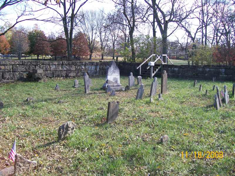
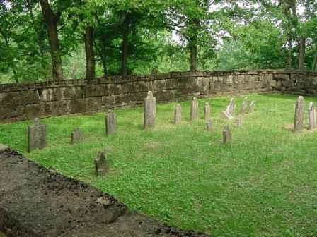
| Description | : | The Edward Tyler Family Cemetery is located on the north side of Taylorsville Road east of Jeffersontown and west of the Snyder Freeway. It is surrounded by a 19th century professionally quarried stone wall measuring 50’ by 70’ and made of large slabs, some nearly nine feet in length. There are 26 marked graves, all for individuals who died before 1850. Of those buried here, 16 lived in Kentucky prior to 1800. Three served in the War of 1812, two of those fought at the Battle of the Thames, one at the Battle of New Orleans, and have... Read More |
frequently asked questions (FAQ):
-
Where is Tyler Cemetery?
Tyler Cemetery is located at 12203 Taylorsville Road Jeffersontown, Jefferson County ,Kentucky , 40299USA.
-
Tyler Cemetery cemetery's updated grave count on graveviews.com?
3 memorials
-
Where are the coordinates of the Tyler Cemetery?
Latitude: 38.1876800
Longitude: -85.5304900
Nearby Cemetories:
1. William Tyler Cemetery
Jeffersontown, Jefferson County, USA
Coordinate: 38.1852250, -85.5393520
2. Blankenbeker Cemetery
Jeffersontown, Jefferson County, USA
Coordinate: 38.1995380, -85.5171550
3. Hopewell Cemetery
Jeffersontown, Jefferson County, USA
Coordinate: 38.1862660, -85.5103680
4. Easum Family Cemetery
Jeffersontown, Jefferson County, USA
Coordinate: 38.1709590, -85.5421710
5. Jeffersontown Christian Church Peace Garden
Jefferson County, USA
Coordinate: 38.1897710, -85.5571860
6. Snyder Cemetery
Jeffersontown, Jefferson County, USA
Coordinate: 38.2073270, -85.5507020
7. William E. Hobbs Cemetery
Jeffersontown, Jefferson County, USA
Coordinate: 38.2068570, -85.5549620
8. German Reformed Presbyterian Cemetery
Jeffersontown, Jefferson County, USA
Coordinate: 38.1959400, -85.5634600
9. Jefferson County Poor Farm Cemetery
Jeffersontown, Jefferson County, USA
Coordinate: 38.1976420, -85.5628280
10. Orr Cemetery
Jeffersontown, Jefferson County, USA
Coordinate: 38.2150900, -85.5338200
11. Country Home Cemetery
Jeffersontown, Jefferson County, USA
Coordinate: 38.2036018, -85.5591965
12. Blankenbaker Family Cemetery
Jeffersontown, Jefferson County, USA
Coordinate: 38.2160100, -85.5340500
13. Jeffersontown Cemetery
Jeffersontown, Jefferson County, USA
Coordinate: 38.1922000, -85.5685000
14. Saint Edward Catholic Cemetery
Jeffersontown, Jefferson County, USA
Coordinate: 38.1888500, -85.5693900
15. Mount Zion Lutheran Cemetery
Jeffersontown, Jefferson County, USA
Coordinate: 38.2114582, -85.5049585
16. Simpson Memorial Gardens
Jeffersontown, Jefferson County, USA
Coordinate: 38.1889944, -85.5719833
17. Chenoweth Run Cemetery
Fern Creek, Jefferson County, USA
Coordinate: 38.1563988, -85.5543976
18. Floyds Fork Burying Ground
Fisherville, Jefferson County, USA
Coordinate: 38.1812010, -85.4782440
19. Hite Family Cemetery
Louisville, Jefferson County, USA
Coordinate: 38.1835790, -85.5867700
20. Cane Run Methodist Church Cemetery
Fisherville, Jefferson County, USA
Coordinate: 38.1569640, -85.4870210
21. Crosswater Gardens
Louisville, Jefferson County, USA
Coordinate: 38.1407300, -85.5416600
22. Community of Christ Scripture Garden
Forest Hills, Jefferson County, USA
Coordinate: 38.2117500, -85.5834480
23. Funk Cemetery
Forest Hills, Jefferson County, USA
Coordinate: 38.2153500, -85.5878160
24. Garr Family Cemetery
Louisville, Jefferson County, USA
Coordinate: 38.2319880, -85.5745940