
| Memorials | : | 0 |
| Location | : | Linwood, Leavenworth County, USA |
| Coordinate | : | 39.0013351, -95.0370407 |
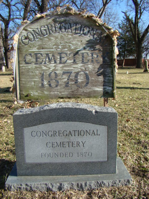
| Description | : | Established in 1870, there are no new headstones only older ones, doesn't appear to be used for new burials. |
frequently asked questions (FAQ):
-
Where is Union Congregational Cemetery?
Union Congregational Cemetery is located at Linwood, Leavenworth County ,Kansas ,USA.
-
Union Congregational Cemetery cemetery's updated grave count on graveviews.com?
0 memorials
-
Where are the coordinates of the Union Congregational Cemetery?
Latitude: 39.0013351
Longitude: -95.0370407
Nearby Cemetories:
1. Mount Sidney Cemetery
Linwood, Leavenworth County, USA
Coordinate: 39.0017014, -95.0243988
2. Chance Cemetery
Linwood, Leavenworth County, USA
Coordinate: 39.0018997, -95.0156021
3. Sarcoxie Cemetery
Linwood, Leavenworth County, USA
Coordinate: 39.0410995, -95.0186005
4. DeSoto Cemetery
De Soto, Johnson County, USA
Coordinate: 38.9710999, -94.9882965
5. Villa Eden Cemetery
Fall Leaf, Leavenworth County, USA
Coordinate: 38.9928500, -95.0985000
6. Delaware Cemetery
Linwood, Leavenworth County, USA
Coordinate: 38.9642982, -95.0936356
7. Lenape Cemetery
Lenape, Leavenworth County, USA
Coordinate: 39.0074997, -94.9602966
8. Luckan Family Cemetery
Fall Leaf, Leavenworth County, USA
Coordinate: 38.9808500, -95.1128000
9. Eudora City Cemetery
Eudora, Douglas County, USA
Coordinate: 38.9455986, -95.0892029
10. Holy Family Cemetery
Eudora, Douglas County, USA
Coordinate: 38.9438050, -95.0933570
11. Reno Cemetery
Reno, Leavenworth County, USA
Coordinate: 39.0505600, -95.1165237
12. Cedar Junction Cemetery
Cedar, Johnson County, USA
Coordinate: 38.9776800, -94.9339500
13. Southwest City Cemetery
Eudora, Douglas County, USA
Coordinate: 38.9334800, -95.1070300
14. Elm Grove Cemetery
Mahon, Leavenworth County, USA
Coordinate: 39.0582085, -94.9450150
15. Cemetery Beni Israel
Eudora, Douglas County, USA
Coordinate: 38.9280128, -95.1122208
16. Himple Cemetery
Tonganoxie, Leavenworth County, USA
Coordinate: 39.0980988, -95.0192032
17. Sacred Heart Cemetery
Tonganoxie, Leavenworth County, USA
Coordinate: 39.0918884, -95.0887222
18. Maple Grove Cemetery
Tonganoxie, Leavenworth County, USA
Coordinate: 39.0918999, -95.0888977
19. Hesper Friends Church Cemetery
Hesper, Douglas County, USA
Coordinate: 38.8984413, -95.0635910
20. Prairie Center Cemetery
De Soto, Johnson County, USA
Coordinate: 38.8925018, -95.0286026
21. Pony Creek Cemetery
Leavenworth County, USA
Coordinate: 39.0730500, -95.1594400
22. Tonganoxie Cemetery
Tonganoxie, Leavenworth County, USA
Coordinate: 39.1093559, -95.1092987
23. Murphy Cemetery
Lenexa, Johnson County, USA
Coordinate: 38.9709282, -94.8816986
24. Glenwood Cemetery
Fairmount Township, Leavenworth County, USA
Coordinate: 39.1080017, -94.9449005