
| Memorials | : | 5 |
| Location | : | Leavenworth County, USA |
| Coordinate | : | 39.0730500, -95.1594400 |
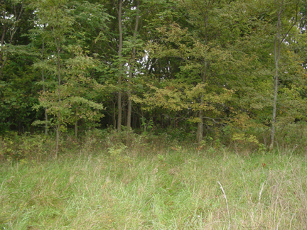
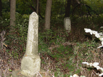
| Description | : | Also known as Plummer Cemetery, located about 6 miles SW of Tonganoxie, Leavenworth Co, KS. The land was originally inhabited by the Delaware Indians and sold to the US Government. The railroad bought up all the land in the area from the government to resell except for 80 acres referred to as the "Lost Eighty" which is now the Rose Farm. Many Indian graves, marked with squared stones piled up on the graves, were on the "Lost Eighty". Legend referred to one as White Cemetery, the other as Indian Cemetery, separated by a low stone wall. Both... Read More |
frequently asked questions (FAQ):
-
Where is Pony Creek Cemetery?
Pony Creek Cemetery is located at Leavenworth County ,Kansas ,USA.
-
Pony Creek Cemetery cemetery's updated grave count on graveviews.com?
5 memorials
-
Where are the coordinates of the Pony Creek Cemetery?
Latitude: 39.0730500
Longitude: -95.1594400
Nearby Cemetories:
1. Reno Cemetery
Reno, Leavenworth County, USA
Coordinate: 39.0505600, -95.1165237
2. Tonganoxie Cemetery
Tonganoxie, Leavenworth County, USA
Coordinate: 39.1093559, -95.1092987
3. Maple Grove Cemetery
Tonganoxie, Leavenworth County, USA
Coordinate: 39.0918999, -95.0888977
4. Sacred Heart Cemetery
Tonganoxie, Leavenworth County, USA
Coordinate: 39.0918884, -95.0887222
5. Chester Cemetery
Williamstown, Jefferson County, USA
Coordinate: 39.0766780, -95.2572680
6. Hardy Oak Cemetery
McLouth, Jefferson County, USA
Coordinate: 39.1166992, -95.2474976
7. Maple Grove Cemetery
Lawrence, Douglas County, USA
Coordinate: 39.0018997, -95.2316971
8. Villa Eden Cemetery
Fall Leaf, Leavenworth County, USA
Coordinate: 38.9928500, -95.0985000
9. Luckan Family Cemetery
Fall Leaf, Leavenworth County, USA
Coordinate: 38.9808500, -95.1128000
10. Adams Cemetery
Douglas County, USA
Coordinate: 38.9955400, -95.2509100
11. Moore-Summit Cemetery
Tonganoxie, Leavenworth County, USA
Coordinate: 39.1417440, -95.0554280
12. Wild Horse Cemetery
McLouth, Jefferson County, USA
Coordinate: 39.1801796, -95.1968307
13. Himple Cemetery
Tonganoxie, Leavenworth County, USA
Coordinate: 39.0980988, -95.0192032
14. Sarcoxie Cemetery
Linwood, Leavenworth County, USA
Coordinate: 39.0410995, -95.0186005
15. Eagle Cemetery
Jarbalo, Leavenworth County, USA
Coordinate: 39.1861000, -95.1239014
16. Underwood Cemetery
Perry, Jefferson County, USA
Coordinate: 39.0661011, -95.3116989
17. Union Congregational Cemetery
Linwood, Leavenworth County, USA
Coordinate: 39.0013351, -95.0370407
18. Delaware Cemetery
Linwood, Leavenworth County, USA
Coordinate: 38.9642982, -95.0936356
19. Oak Hill Cemetery
Lawrence, Douglas County, USA
Coordinate: 38.9589005, -95.2118988
20. Mount Calvary Catholic Cemetery
Lawrence, Douglas County, USA
Coordinate: 38.9580002, -95.2139969
21. Berger Burial Site
Tonganoxie, Leavenworth County, USA
Coordinate: 39.1411100, -95.0269600
22. Trinity Episcopal Church Columbarium
Lawrence, Douglas County, USA
Coordinate: 38.9653893, -95.2373886
23. Memorial Park Cemetery
Lawrence, Douglas County, USA
Coordinate: 38.9552994, -95.2153015
24. Mount Sidney Cemetery
Linwood, Leavenworth County, USA
Coordinate: 39.0017014, -95.0243988