
| Memorials | : | 0 |
| Location | : | Birmingham, Jefferson County, USA |
| Coordinate | : | 33.5438772, -86.7203427 |
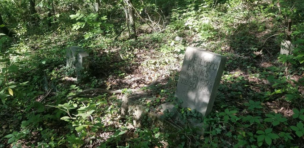
| Description | : | An unnamed abandoned cemetery in the woods off Oporto Madrid Blvd. Approx 150 - 200 graves, mostly unmarked or at most with a piece of stone. Several grave markers exist with the latest dated 1950. |
frequently asked questions (FAQ):
-
Where is Unnamed African American Cemetery?
Unnamed African American Cemetery is located at Near intersection of 67th Street and Oporto Madrid Blvd Birmingham, Jefferson County ,Alabama , 35206USA.
-
Unnamed African American Cemetery cemetery's updated grave count on graveviews.com?
0 memorials
-
Where are the coordinates of the Unnamed African American Cemetery?
Latitude: 33.5438772
Longitude: -86.7203427
Nearby Cemetories:
1. Bush Cemetery
Jefferson County, USA
Coordinate: 33.5327988, -86.7144012
2. East Lake Cemetery
Birmingham, Jefferson County, USA
Coordinate: 33.5621986, -86.7266998
3. Wood Cemetery
Birmingham, Jefferson County, USA
Coordinate: 33.5427246, -86.7507935
4. McElwain Baptist Cemetery
Birmingham, Jefferson County, USA
Coordinate: 33.5186005, -86.7296982
5. Greenwood Cemetery
Birmingham, Jefferson County, USA
Coordinate: 33.5522003, -86.7528000
6. Forest Hill Cemetery
Birmingham, Jefferson County, USA
Coordinate: 33.5485992, -86.7542038
7. Saint Francis Xavier Catholic Church Columbarium
Birmingham, Jefferson County, USA
Coordinate: 33.5161100, -86.7421910
8. Wilson Chapel Cemetery
Birmingham, Jefferson County, USA
Coordinate: 33.5815800, -86.7054610
9. Earltown Cemetery
Jefferson County, USA
Coordinate: 33.5513992, -86.6733017
10. Higgins Cemetery
Jefferson County, USA
Coordinate: 33.5881004, -86.7249985
11. Phillips Family Cemetery (Defunct)
Birmingham, Jefferson County, USA
Coordinate: 33.5439600, -86.6651580
12. Zion Memorial Gardens
Birmingham, Jefferson County, USA
Coordinate: 33.5908050, -86.7225660
13. Saint Lukes Episcopal Columbarium
Mountain Brook, Jefferson County, USA
Coordinate: 33.5011444, -86.7465210
14. Bass Cemetery
Irondale, Jefferson County, USA
Coordinate: 33.5744019, -86.6733017
15. Inglenook Cemetery
Jefferson County, USA
Coordinate: 33.5630989, -86.7778015
16. New Hope Cemetery
Irondale, Jefferson County, USA
Coordinate: 33.5281219, -86.6607361
17. Mountain Brook Baptist Church Columbarium
Homewood, Jefferson County, USA
Coordinate: 33.4961508, -86.7576237
18. Mountain Brook Presbyterian Cemetery
Mountain Brook, Jefferson County, USA
Coordinate: 33.4876580, -86.7324580
19. Huffman Methodist Church Cemetery
Birmingham, Jefferson County, USA
Coordinate: 33.5966301, -86.6913910
20. Independent Presbyterian Church Columbarium
Birmingham, Jefferson County, USA
Coordinate: 33.5082925, -86.7798770
21. Old Pioneer Cemetery
Birmingham, Jefferson County, USA
Coordinate: 33.5172950, -86.7865530
22. Canterbury United Methodist Church Columbarium
Birmingham, Jefferson County, USA
Coordinate: 33.4892320, -86.7558260
23. Red Mountain Cemetery
Birmingham, Jefferson County, USA
Coordinate: 33.4887009, -86.7777023
24. Baptist Church of the Covenant Columbarium
Birmingham, Jefferson County, USA
Coordinate: 33.5055850, -86.7963910