
| Memorials | : | 0 |
| Location | : | Bury, Metropolitan Borough of Bury, England |
| Coordinate | : | 53.5667900, -2.2745100 |
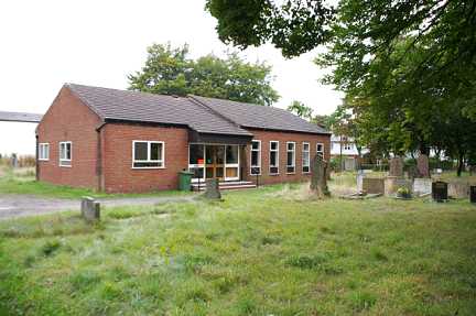
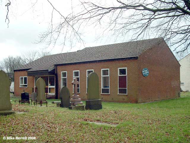
| Description | : | The original chapel was built on this site in 1847 but was demolished and a new building erected in 1980. The Church closed in 2011 and as of 2014 the site is up for sale. Many of the slab graves are hidden under a thick layer of moss and vegetation and some of the upright stones have fallen or been vandalised. ***PLEASE NOTE- There is no option to select Unsworth as place of death in the FAG list... We'll be adding the transcriptions and photos over the next few weeks. Sefton and Lancashire Lass |
frequently asked questions (FAQ):
-
Where is Unsworth Weslyan Methodist Churchyard?
Unsworth Weslyan Methodist Churchyard is located at Hollins Lane, Unsworth, Bury, Lancs Bury, Metropolitan Borough of Bury ,Greater Manchester , BL9 8AWEngland.
-
Unsworth Weslyan Methodist Churchyard cemetery's updated grave count on graveviews.com?
0 memorials
-
Where are the coordinates of the Unsworth Weslyan Methodist Churchyard?
Latitude: 53.5667900
Longitude: -2.2745100
Nearby Cemetories:
1. St Georges Churchyard
Unsworth, Metropolitan Borough of Bury, England
Coordinate: 53.5668741, -2.2745340
2. Bury Cemetery
Bury, Metropolitan Borough of Bury, England
Coordinate: 53.5794850, -2.2904870
3. St Paul Churchyard
Bury, Metropolitan Borough of Bury, England
Coordinate: 53.5789815, -2.2925926
4. St. Mary's Churchyard
Radcliffe, Metropolitan Borough of Bury, England
Coordinate: 53.5644410, -2.3081470
5. All Saints Churchyard Stand
Whitefield, Metropolitan Borough of Bury, England
Coordinate: 53.5501180, -2.2985570
6. Manchester Reform Jewish Old Cemetery
Whitefield, Metropolitan Borough of Bury, England
Coordinate: 53.5442728, -2.2918894
7. Stand United Reformed Church Burial Ground
Radcliffe, Metropolitan Borough of Bury, England
Coordinate: 53.5512300, -2.3140600
8. New Jerusalem Church Burial
Radcliffe, Metropolitan Borough of Bury, England
Coordinate: 53.5542680, -2.3174070
9. St. John Parish Churchyard
Radcliffe, Metropolitan Borough of Bury, England
Coordinate: 53.5571400, -2.3206700
10. St. Mary's Churchyard Birch-In-Hopwood
Heywood, Metropolitan Borough of Rochdale, England
Coordinate: 53.5662410, -2.2247560
11. St John's Churchyard
Bury, Metropolitan Borough of Bury, England
Coordinate: 53.5954900, -2.2910100
12. St. Thomas & St. John with St. Philip Churchyard
Radcliffe, Metropolitan Borough of Bury, England
Coordinate: 53.5625140, -2.3266770
13. East Lancashire Crematorium
Radcliffe, Metropolitan Borough of Bury, England
Coordinate: 53.5726893, -2.3273050
14. Brunswick Methodist Cemetery
Bury, Metropolitan Borough of Bury, England
Coordinate: 53.5968361, -2.2932912
15. Radcliffe Cemetery
Radcliffe, Metropolitan Borough of Bury, England
Coordinate: 53.5706240, -2.3294860
16. Wellington Barracks Memorial Garden
Bury, Metropolitan Borough of Bury, England
Coordinate: 53.5882208, -2.3210890
17. Great Synagogue Cemetery
Prestwich, Metropolitan Borough of Bury, England
Coordinate: 53.5315510, -2.2845730
18. All Saints Churchyard Rhodes
Middleton, Metropolitan Borough of Rochdale, England
Coordinate: 53.5437200, -2.2261400
19. All Saints Churchyard
Elton, Metropolitan Borough of Bury, England
Coordinate: 53.5965000, -2.3118000
20. St. Mary the Virgin Churchyard
Prestwich, Metropolitan Borough of Bury, England
Coordinate: 53.5294033, -2.2864891
21. St. Andrew's Churchyard
Radcliffe, Metropolitan Borough of Bury, England
Coordinate: 53.5740731, -2.3377989
22. Blackley Cemetery and Crematorium
Blackley, Metropolitan Borough of Manchester, England
Coordinate: 53.5333176, -2.2394190
23. St. James Churchyard
Bury, Metropolitan Borough of Bury, England
Coordinate: 53.5996770, -2.3214600
24. Rainsough Jewish Cemetery
Prestwich, Metropolitan Borough of Bury, England
Coordinate: 53.5185530, -2.2906950