
| Memorials | : | 0 |
| Location | : | Vail, Pima County, USA |
| Coordinate | : | 32.0575470, -110.7024970 |
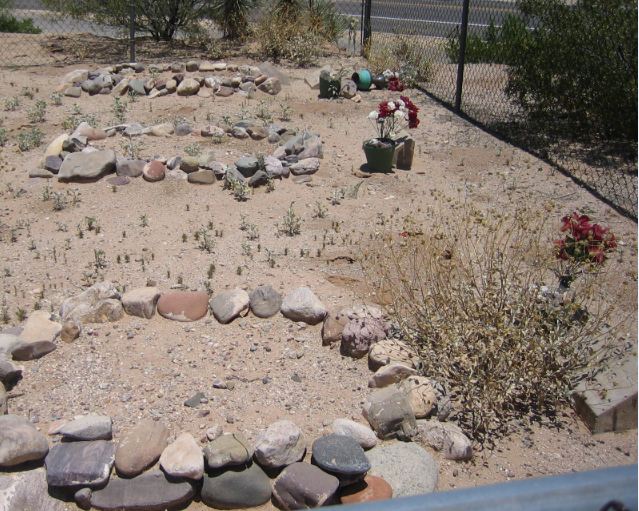
| Description | : | This is not an actual cemetery, just 3 graves on the side of the road that have been fenced off, probably to preserve them. They are near a newer housing development and golf course in Vail, Arizona. They are located on East Via Rancho Del Lago Road, on the left side, between East El Diablo Creek Dr. and S. Moss Lane. The zip code is 85641. Via Rancho Del Lago Road is off East Colossal Cave Road. |
frequently asked questions (FAQ):
-
Where is Via Rancho Del Lago Roadside Graves?
Via Rancho Del Lago Roadside Graves is located at East Via Rancho Del Lago Rd. Vail, Pima County ,Arizona , 85641USA.
-
Via Rancho Del Lago Roadside Graves cemetery's updated grave count on graveviews.com?
0 memorials
-
Where are the coordinates of the Via Rancho Del Lago Roadside Graves?
Latitude: 32.0575470
Longitude: -110.7024970
Nearby Cemetories:
1. Vail Childrens' Cemetery
Vail, Pima County, USA
Coordinate: 32.0495520, -110.7132630
2. Leon Cemetery
Vail, Pima County, USA
Coordinate: 32.0811200, -110.7142310
3. Rincon Cemetery
Tucson, Pima County, USA
Coordinate: 32.1216660, -110.7129974
4. Pantano Cemetery
Pantano, Pima County, USA
Coordinate: 32.0010390, -110.5801690
5. All Faiths Memorial Park
Tucson, Pima County, USA
Coordinate: 32.1958008, -110.7596970
6. Firemans Cemetery
Tucson, Pima County, USA
Coordinate: 32.1436410, -110.8506770
7. Immanuel Presbyterian Church Memorial Garden
Tucson, Pima County, USA
Coordinate: 32.2055930, -110.7948940
8. Saint Matthew Episcopal Church Memorial Garden
Tucson, Pima County, USA
Coordinate: 32.2111600, -110.7998000
9. New Spirit Lutheran Church Columbarium
Tucson, Pima County, USA
Coordinate: 32.2167690, -110.8054810
10. Tanque Verde Ranch Cemetery
Tucson, Pima County, USA
Coordinate: 32.2408218, -110.6870422
11. Tanque Verde Cemetery
Tanque Verde, Pima County, USA
Coordinate: 32.2391777, -110.7361984
12. Total Wreck Cemetery
Pima County, USA
Coordinate: 31.8955580, -110.5927510
13. Saguaro Christian Church Memorial Garden
Tucson, Pima County, USA
Coordinate: 32.2202400, -110.8148300
14. White Cross Cemetery
Pima County, USA
Coordinate: 32.0278015, -110.4816971
15. Saint Pauls Memorial Garden
Tucson, Pima County, USA
Coordinate: 32.2218020, -110.8207650
16. Fountain of Life Lutheran Church Columbarium
Tucson, Pima County, USA
Coordinate: 32.2122730, -110.8418410
17. Christ Presbyterian Church Memorial Garden
Tucson, Pima County, USA
Coordinate: 32.2214500, -110.8529200
18. Saint Michael and All Angels Episc. Church Garden
Tucson, Pima County, USA
Coordinate: 32.2293400, -110.8569500
19. Tanque Verde Lutheran Church Columbarium
Tucson, Pima County, USA
Coordinate: 32.2603140, -110.8068040
20. Rincon Congregational Church Columbarium
Tucson, Pima County, USA
Coordinate: 32.2241880, -110.8749300
21. Helvetia Cemetery
Pima County, USA
Coordinate: 31.8514004, -110.8080978
22. Christ Church United Methodist Memorial Garden
Tucson, Pima County, USA
Coordinate: 32.2304100, -110.8757900
23. South Lawn Memorial Cemetery
Tucson, Pima County, USA
Coordinate: 32.1521988, -110.9494019
24. Ahmadiyya Muslim Cemetery
Tucson, Pima County, USA
Coordinate: 32.1520360, -110.9513440