
| Memorials | : | 0 |
| Location | : | Wards Island, New York County (Manhattan), USA |
| Coordinate | : | 40.7846000, -73.9293100 |
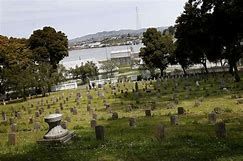
| Description | : | Closed, No longer in existance. Genealogy note: In 1857, the remains of 100,000 paupers and strangers were transferred to Ward's Island, 75 acres of which were allocated for this purpose. Wards Island is situated in the East River in New York City. Administratively it is part of the borough of Manhattan. It is bridged by rail to the borough of Queens by the Hell Gate Bridge and it is joined to Randall's Island to the north by landfill. The two islands together are run by the Randall's Island Sports Foundation under a partnership agreement with the New York City Department of Parks... Read More |
frequently asked questions (FAQ):
-
Where is Wards Island Cemetery?
Wards Island Cemetery is located at Wards Island, New York County (Manhattan) ,New York ,USA.
-
Wards Island Cemetery cemetery's updated grave count on graveviews.com?
0 memorials
-
Where are the coordinates of the Wards Island Cemetery?
Latitude: 40.7846000
Longitude: -73.9293100
Nearby Cemetories:
1. Randalls Island Burial Ground
Randalls Island, New York County (Manhattan), USA
Coordinate: 40.7912970, -73.9226250
2. New York House of Refuge Grounds Cemetery
Manhattan, New York County (Manhattan), USA
Coordinate: 40.7931683, -73.9279023
3. Rapelje Cemetery
Queens County, USA
Coordinate: 40.7827820, -73.9146340
4. Our Lady of Mount Carmel Catholic Cemetery
Astoria, Queens County, USA
Coordinate: 40.7737122, -73.9250183
5. Saint George Church Cemetery
Astoria, Queens County, USA
Coordinate: 40.7726540, -73.9286140
6. Hallett's Burying Ground (Defunct)
Astoria, Queens County, USA
Coordinate: 40.7721460, -73.9321570
7. Berrien Island Cemetery
Astoria, Queens County, USA
Coordinate: 40.7842070, -73.9120700
8. Yorkville Cemetery
Manhattan, New York County (Manhattan), USA
Coordinate: 40.7829450, -73.9489660
9. Dutch Reformed Church Cemetery of Harlem (Defunct)
Harlem, New York County (Manhattan), USA
Coordinate: 40.8014950, -73.9317320
10. Dutch Reformed Church of Harlem Churchyard
Manhattan, New York County (Manhattan), USA
Coordinate: 40.8015520, -73.9382390
11. Isamu Noguchi Garden Museum
Long Island City, Queens County, USA
Coordinate: 40.7667020, -73.9379410
12. Lawrence Cemetery
Astoria, Queens County, USA
Coordinate: 40.7773800, -73.9056200
13. Brick Presbyterian Church Cemetery
Manhattan, New York County (Manhattan), USA
Coordinate: 40.7836110, -73.9550000
14. Anshe Chesed Hebrew Cemetery
Manhattan, New York County (Manhattan), USA
Coordinate: 40.7828400, -73.9572330
15. New York City 88th Street Cemetery
Manhattan, New York County (Manhattan), USA
Coordinate: 40.7821730, -73.9578320
16. Episcopal Church of the Heavenly Rest Columbarium
Manhattan, New York County (Manhattan), USA
Coordinate: 40.7838300, -73.9584400
17. Saint Andrews Episcopal Churchyard
Harlem, New York County (Manhattan), USA
Coordinate: 40.8066430, -73.9374220
18. Blackwell Burial Ground (Defunct)
Astoria, Queens County, USA
Coordinate: 40.7613350, -73.9425380
19. Saint Ann's Episcopal Church Graveyard
Bronx, Bronx County, USA
Coordinate: 40.8081100, -73.9167700
20. Madison Avenue Presbyterian Church Columbarium
New York, New York County (Manhattan), USA
Coordinate: 40.7724900, -73.9645740
21. Bass Hardenbrook Family Cemetery
New York, New York County (Manhattan), USA
Coordinate: 40.7628540, -73.9559670
22. Saint Michael's Cemetery
East Elmhurst, Queens County, USA
Coordinate: 40.7647018, -73.8993988
23. Riker-Lent Burial Ground
Astoria, Queens County, USA
Coordinate: 40.7734100, -73.8922120
24. Saint James Episcopal Church Columbarium
Manhattan, New York County (Manhattan), USA
Coordinate: 40.7712326, -73.9656067