
| Memorials | : | 24 |
| Location | : | Gloucester, Gloucester County, USA |
| Website | : | warechurch.org/default.asp |
| Coordinate | : | 37.4227470, -76.5078880 |
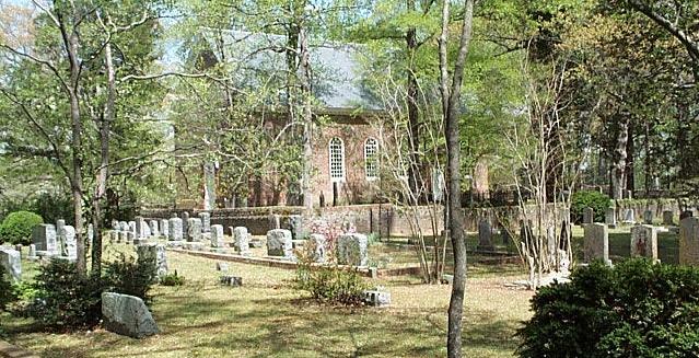
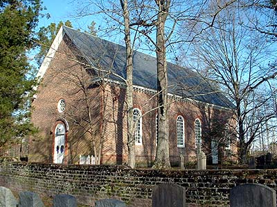
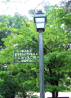
| Description | : | Ware Episcopal Church is located on Rt. 14, about one mile northeast of Gloucester Courthouse beside the road toward Mathews. Information about the church and its cemetery is available online at http://warechurch.org. The parish office is on site and open most mornings. Ware Parish was established around 1652, and the still-active colonial church was built about 1718. An earlier parish church was located about a mile east on the Ware River. The first burial at the current Ware Church site was for the Rev. James Clack, in 1723. There are just over a thousand gravestones in the cemetery, including... Read More |
frequently asked questions (FAQ):
-
Where is Ware Episcopal Church Cemetery?
Ware Episcopal Church Cemetery is located at 7825 John Clayton Memorial Highway Gloucester, Gloucester County ,Virginia , 23061USA.
-
Ware Episcopal Church Cemetery cemetery's updated grave count on graveviews.com?
22 memorials
-
Where are the coordinates of the Ware Episcopal Church Cemetery?
Latitude: 37.4227470
Longitude: -76.5078880
Nearby Cemetories:
1. First Presbyterian Church Columbarium
Gloucester, Gloucester County, USA
Coordinate: 37.4150300, -76.5310400
2. Zion Poplars Baptist Church Cemetery
Gloucester, Gloucester County, USA
Coordinate: 37.3994320, -76.5085530
3. Shiloh Cemetery
Gloucester, Gloucester County, USA
Coordinate: 37.3996010, -76.5123030
4. Newington Baptist Church Cemetery
Gloucester, Gloucester County, USA
Coordinate: 37.4174900, -76.5422420
5. Mount Zion United Methodist Church Cemetery
Gloucester, Gloucester County, USA
Coordinate: 37.4506600, -76.4724080
6. Peter W. Smith Family Cemetery
Gloucester County, USA
Coordinate: 37.3852759, -76.4637594
7. Yeatman Plantation Cemetery
Foster, Mathews County, USA
Coordinate: 37.4360966, -76.4426093
8. Gayle-Hudgins Cemetery
Mathews County, USA
Coordinate: 37.4313801, -76.4413433
9. Saint Pauls Cemetery
Roanes, Gloucester County, USA
Coordinate: 37.3678017, -76.5000000
10. Singleton United Methodist Church Cemetery
Schley, Gloucester County, USA
Coordinate: 37.3909380, -76.4508860
11. First United Baptist Church Cemetery
Gloucester, Gloucester County, USA
Coordinate: 37.3713340, -76.5344850
12. Shepherdsville Baptist Church Cemetery
Gloucester County, USA
Coordinate: 37.4509200, -76.5684680
13. Pole Bridge Cemetery
Ware Neck, Gloucester County, USA
Coordinate: 37.4023590, -76.4399470
14. Rising Valley Baptist Church Cemetery
Gloucester County, USA
Coordinate: 37.4663940, -76.4589210
15. Grace Bible Church Cemetery
Ark, Gloucester County, USA
Coordinate: 37.4411260, -76.5790070
16. Auburn Cemetery
Mathews, Mathews County, USA
Coordinate: 37.4231620, -76.4311980
17. Zion Hill Baptist Church Cemetery
Gloucester, Gloucester County, USA
Coordinate: 37.4840290, -76.5263470
18. Jarvis Cemetery
Schley, Gloucester County, USA
Coordinate: 37.3820700, -76.4468000
19. Beulah Baptist Church Cemetery
Schley, Gloucester County, USA
Coordinate: 37.3837980, -76.4425980
20. Bellamy Memorial Cemetery
Bellamy, Gloucester County, USA
Coordinate: 37.4014940, -76.5888260
21. Davis Cemetery
Gloucester County, USA
Coordinate: 37.4009490, -76.4248900
22. Oak Grove Cemetery
Selden, Gloucester County, USA
Coordinate: 37.3563995, -76.4666977
23. Smithfield Baptist Church Cemetery
Gloucester, Gloucester County, USA
Coordinate: 37.3703300, -76.5748250
24. Chandler Cemetery
Gloucester County, USA
Coordinate: 37.3829460, -76.4282580