
| Memorials | : | 120 |
| Location | : | Washingtonville, Mahoning County, USA |
| Coordinate | : | 40.9033012, -80.7846985 |
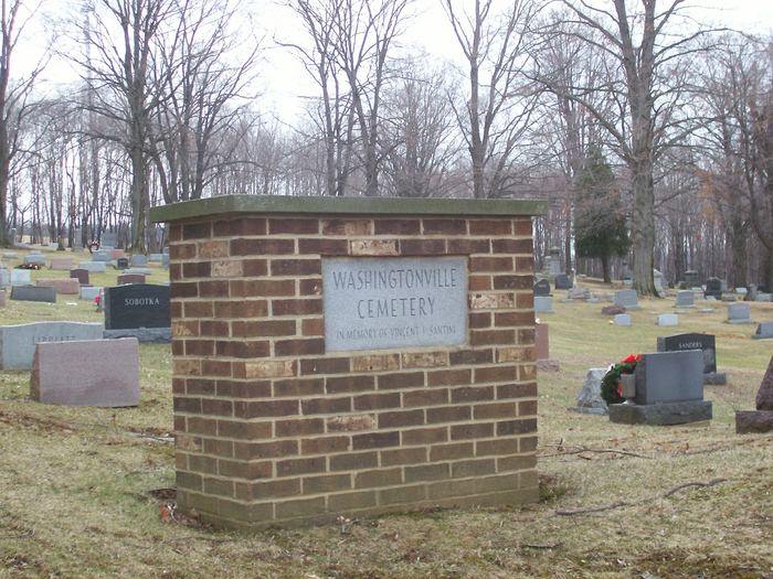
| Description | : | The cemetery is located on the east side of Lisbon Road (County Road 99) about 0.2 miles north of its intersection with Salem-Unity Road (Ohio State Route 14). The cemetery was established in 1815. The cemetery is located in Sharon Township, Mahoning County, Ohio, and is # 7261 (I.O.O.F. Cemetery / Washingtonville Cemetery) in “Ohio Cemeteries 1803-2003”, compiled by the Ohio Genealogical Society. The cemetery is registered with the Ohio Division of Real Estate and Professional Licensing (ODRE) as Washingtonville Cemetery Association with registration license number CBR.0000982177. The U.S. Geological Survey (USGS) Geographic Names Information System (GNIS) feature... Read More |
frequently asked questions (FAQ):
-
Where is Washingtonville Cemetery?
Washingtonville Cemetery is located at Lisbon Road (County Road 99) Washingtonville, Mahoning County ,Ohio , 44460USA.
-
Washingtonville Cemetery cemetery's updated grave count on graveviews.com?
120 memorials
-
Where are the coordinates of the Washingtonville Cemetery?
Latitude: 40.9033012
Longitude: -80.7846985
Nearby Cemetories:
1. Robbins Methodist Cemetery
Washingtonville, Mahoning County, USA
Coordinate: 40.9016000, -80.7650800
2. Trinity Lutheran Cemetery
Washingtonville, Mahoning County, USA
Coordinate: 40.9013880, -80.7646550
3. Mount Joy Mennonite Church Cemetery
Leetonia, Columbiana County, USA
Coordinate: 40.8922670, -80.7600100
4. Callahan Family Cemetery
Greenford, Mahoning County, USA
Coordinate: 40.9160550, -80.8083680
5. Dressel Farm Cemetery
Greenford, Mahoning County, USA
Coordinate: 40.9363770, -80.7745730
6. Sharon Mennonite Fellowship Cemetery
Green Township, Mahoning County, USA
Coordinate: 40.9286850, -80.7463390
7. Greenlawn Cemetery
Greenford, Mahoning County, USA
Coordinate: 40.9430000, -80.7970000
8. Greenford Lutheran Church Cemetery
Mahoning County, USA
Coordinate: 40.9436700, -80.7970200
9. Mount Calvary Cemetery
Leetonia, Columbiana County, USA
Coordinate: 40.8630981, -80.7667007
10. Christian Cemetery
Greenford, Mahoning County, USA
Coordinate: 40.9438705, -80.8023529
11. Nold Mennonite Cemetery
Leetonia, Columbiana County, USA
Coordinate: 40.8771820, -80.7394080
12. Oakdale Cemetery
Leetonia, Columbiana County, USA
Coordinate: 40.8666992, -80.7538986
13. Locust Grove Cemetery
Mahoning County, USA
Coordinate: 40.9435300, -80.7631500
14. Paupers Field
Salem, Columbiana County, USA
Coordinate: 40.8882050, -80.8388590
15. Grandview Cemetery
Salem, Columbiana County, USA
Coordinate: 40.8856010, -80.8405991
16. Esterly Cemetery
Leetonia, Columbiana County, USA
Coordinate: 40.8886700, -80.7270200
17. Franklin Square United Methodist Church Cemetery
Franklin Square, Columbiana County, USA
Coordinate: 40.8562902, -80.7902739
18. Franklin Square Cemetery
Franklin Square, Columbiana County, USA
Coordinate: 40.8580017, -80.8029022
19. Pleasant View Mennonite Church Cemetery
Mahoning County, USA
Coordinate: 40.9223400, -80.7266500
20. Hope Cemetery
Salem, Columbiana County, USA
Coordinate: 40.9096985, -80.8494034
21. Midway Mennonite Church Cemetery
Mahoning County, USA
Coordinate: 40.9243400, -80.7183500
22. Friends Burial Grounds
Salem, Columbiana County, USA
Coordinate: 40.8976460, -80.8572280
23. New Albany Cemetery
New Albany, Mahoning County, USA
Coordinate: 40.9443640, -80.8388010
24. Zion Hill Church of the Brethren Cemetery
North Lima, Mahoning County, USA
Coordinate: 40.9067700, -80.7052420