
| Memorials | : | 0 |
| Location | : | Bristol Unitary Authority, England |
| Website | : | www.churchcrawler.co.uk/bristol3/wesleyan.htm |
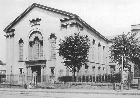
| Description | : | Wesleyan Methodist Chapel was a classical building of 1837 supposedly built on the site where John Wesley first preached. It opened on 22 Nov 1837 and was demolished in 1971 for the M32 junction 3's complex of roads, one of three chapels in Lower Ashley Road (the others were Salem Chapel and Brookland Methodist). |
frequently asked questions (FAQ):
-
Where is Wesleyan Methodist Chapel?
Wesleyan Methodist Chapel is located at No GPS information available Add GPSLower Ashley Road, Baptist Mills Bristol Unitary Authority ,Bristol ,England.
-
Wesleyan Methodist Chapel cemetery's updated grave count on graveviews.com?
0 memorials
Nearby Cemetories:
1. St Michael & All Angels Churchyard
Bishopston, Bristol Unitary Authority, England
2. Greenbank Cemetery
Eastville, Bristol Unitary Authority, England
Coordinate: 51.4575500, -2.5915500
3. Holy Trinity Church & St Philip
Coordinate: 51.4605400, -2.5877800
4. St. Matthew's Churchyard
Kingsdown, Bristol Unitary Authority, England
Coordinate: 51.4213270, -2.5632460
5. Shirehampton Cemetery
Shirehampton, Bristol Unitary Authority, England
Coordinate: 51.4559460, -2.5950320
6. St. Mary's Churchyard
Shirehampton, Bristol Unitary Authority, England
7. St. Mary Magdalene Churchyard
Stoke Bishop, Bristol Unitary Authority, England
Coordinate: 51.4400610, -2.6041020
8. Saint Francis Churchyard
Ashton Gate, Bristol Unitary Authority, England
Coordinate: 51.4559548, -2.5915587
9. All Saints Church
Bristol, Bristol Unitary Authority, England
10. Baptist Chapel
Bristol, Bristol Unitary Authority, England
Coordinate: 51.4572220, -2.5877780
11. Black Friars Priory
Bristol, Bristol Unitary Authority, England
Coordinate: 51.4749930, -2.5488700
12. Bristol Cathedral
Bristol, Bristol Unitary Authority, England
Coordinate: 51.4755800, -2.5494800
13. Bristol Prison Cemetery
Bristol, Bristol Unitary Authority, England
14. Broadmead Baptist Church
Bristol, Bristol Unitary Authority, England
Coordinate: 51.4575500, -2.5915500
15. Brunswick Square Unitarian Burying Ground
Bristol, Bristol Unitary Authority, England
Coordinate: 51.4605400, -2.5877800
16. Christ Church Churchyard
Bristol, Bristol Unitary Authority, England
Coordinate: 51.4213270, -2.5632460
17. Church of St John the Baptist
Bristol, Bristol Unitary Authority, England
Coordinate: 51.4559460, -2.5950320
18. Friends Burial Ground
Bristol, Bristol Unitary Authority, England
19. Hebron Road Burial Ground
Bristol, Bristol Unitary Authority, England
Coordinate: 51.4400610, -2.6041020
20. Holy Trinity Church
Bristol, Bristol Unitary Authority, England
Coordinate: 51.4559548, -2.5915587
21. Jewish Burial Ground Temple (Defunct)
Bristol, Bristol Unitary Authority, England
22. Quakers Friars Burial Ground
Bristol, Bristol Unitary Authority, England
Coordinate: 51.4572220, -2.5877780
23. Ridgeway Jewish Cemetery
Bristol, Bristol Unitary Authority, England
Coordinate: 51.4749930, -2.5488700
24. Ridgeway Park Cemetery
Bristol, Bristol Unitary Authority, England
Coordinate: 51.4755800, -2.5494800