
| Memorials | : | 0 |
| Location | : | Marland, Noble County, USA |
| Coordinate | : | 36.5695300, -97.1448000 |
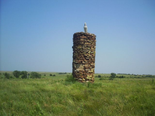
| Description | : | Constructed in 1926 by the 101 Ranch and the Oklahoma Historical Society, this National Historic Landmark is known as Monument Hill. The reconstructed monument was dedicated in 1927 to Ponca Tribal Chief White Eagle. Once the site of an ancient Indian trail marker which served as one of several guide posts for various tribes traveling during seasonal migration and hunting trips. Each tribe as it passed would leave signals by which others could tell who had passed and which way they were traveling. With the relocation of the Ponça Tribe in 1879 from their former holdings along the Nebraska-Dakota border-area,... Read More |
frequently asked questions (FAQ):
-
Where is White Eagle Monument?
White Eagle Monument is located at Marland, Noble County ,Oklahoma ,USA.
-
White Eagle Monument cemetery's updated grave count on graveviews.com?
0 memorials
-
Where are the coordinates of the White Eagle Monument?
Latitude: 36.5695300
Longitude: -97.1448000

Nearby Cemetories:
1. Cowboy Hill Cemetery
Ponca City, Kay County, USA
Coordinate: 36.6068993, -97.1380997
2. Ponca Tribal Cemetery
Ponca City, Kay County, USA
Coordinate: 36.6432991, -97.1132965
3. Otoe-Missouria Cemetery
Red Rock, Noble County, USA
Coordinate: 36.4844017, -97.0717010
4. Otoe-Missouria War Mothers Memorial
Red Rock, Noble County, USA
Coordinate: 36.4831170, -97.0717500
5. Grandview Cemetery
Marland, Noble County, USA
Coordinate: 36.5649400, -97.2792200
6. Cleghorn Cemetery
Red Rock, Noble County, USA
Coordinate: 36.4907990, -97.0357971
7. Oak Grove Cemetery
Ponca City, Kay County, USA
Coordinate: 36.6876500, -97.1072600
8. Saint Marys Catholic Cemetery
Ponca City, Kay County, USA
Coordinate: 36.6875000, -97.1038971
9. Red Rock Cemetery
Red Rock, Noble County, USA
Coordinate: 36.4482994, -97.1735992
10. Odd Fellows Cemetery
Ponca City, Kay County, USA
Coordinate: 36.6893997, -97.1046066
11. Prairie View Cemetery
Tonkawa, Kay County, USA
Coordinate: 36.6002998, -97.3003006
12. Bressie Cemetery
Noble County, USA
Coordinate: 36.5497017, -96.9863968
13. Tonkawa Indian Cemetery
Tonkawa, Kay County, USA
Coordinate: 36.6726100, -97.2643800
14. First Christian Church Columbarium
Ponca City, Kay County, USA
Coordinate: 36.7053210, -97.0788450
15. Round Grove Cemetery
Tonkawa, Kay County, USA
Coordinate: 36.7094002, -97.1967010
16. Ceres Cemetery
Ceres, Noble County, USA
Coordinate: 36.4773610, -97.2877550
17. Grace Episcopal Church Columbarium
Ponca City, Kay County, USA
Coordinate: 36.7037630, -97.0683930
18. Floral Ridge Cemetery
Billings, Noble County, USA
Coordinate: 36.5139900, -97.3190600
19. Pixley Cemetery
Fairfax, Osage County, USA
Coordinate: 36.5074997, -96.9616852
20. Sunset Memorial Park
Osage County, USA
Coordinate: 36.6803017, -96.9935989
21. Sunset Memorial Park
Ponca City, Kay County, USA
Coordinate: 36.6804500, -96.9937000
22. Tonkawa IOOF Cemetery
Tonkawa, Kay County, USA
Coordinate: 36.6955800, -97.3242300
23. Longwood Cemetery
Ponca City, Kay County, USA
Coordinate: 36.7257800, -96.9951700
24. Resthaven Memorial Park
Ponca City, Kay County, USA
Coordinate: 36.7550011, -97.0588989