
| Memorials | : | 0 |
| Location | : | Roanoke, Lewis County, USA |
| Coordinate | : | 38.9228820, -80.4715130 |
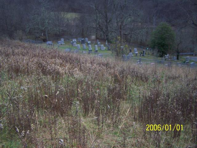
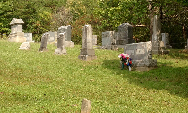
| Description | : | The William L. Smith Cemetery is a rural cemetery located 10.9 miles south of Weston WV on US RT 19 along the Stonewall Jackson Lake. The cemetery has no signs, but shares an access road with the marked Mary Conrad Park entrance on US RT 19. The cemetery is fenced, well maintained, and has public parking and access. The cemetery should not be confused with other "Smith" cemeteries in Lewis County WV such as the Smith's Run Cemetery, the Smith Family Cemetery, and others. |
frequently asked questions (FAQ):
-
Where is William L. Smith Cemetery?
William L. Smith Cemetery is located at Mary Conrad Roadside Park US RT 19 Roanoke, Lewis County ,West Virginia , 26447 USA.
-
William L. Smith Cemetery cemetery's updated grave count on graveviews.com?
0 memorials
-
Where are the coordinates of the William L. Smith Cemetery?
Latitude: 38.9228820
Longitude: -80.4715130
Nearby Cemetories:
1. Whitesell Cemetery
Lewis County, USA
Coordinate: 38.9307760, -80.4844406
2. Fairview Cemetery
Roanoke, Lewis County, USA
Coordinate: 38.9306000, -80.4847000
3. Paul T Mitchell Cemetery
Roanoke, Lewis County, USA
Coordinate: 38.9437210, -80.4905340
4. Briar Point Cemetery
Walkersville, Lewis County, USA
Coordinate: 38.9438170, -80.4905950
5. Dennison Family Cemetery
Walkersville, Lewis County, USA
Coordinate: 38.8932350, -80.4616670
6. Jacksonville Cemetery
Weston, Lewis County, USA
Coordinate: 38.8919890, -80.4935740
7. Rittenhouse Cemetery
Walkersville, Lewis County, USA
Coordinate: 38.8812700, -80.4730520
8. Simons Cemetery
Walkersville, Lewis County, USA
Coordinate: 38.8806490, -80.4731390
9. Hannah Temple Cemetery
Walkersville, Lewis County, USA
Coordinate: 38.8800610, -80.4736130
10. Swecker Cemetery
Roanoke, Lewis County, USA
Coordinate: 38.9428950, -80.5282380
11. Morrison-Hull Cemetery
Walkersville, Lewis County, USA
Coordinate: 38.8929138, -80.4199066
12. Long Point Cemetery
Walkersville, Lewis County, USA
Coordinate: 38.8718987, -80.4666977
13. Hall Family Cemetery
Walkersville, Lewis County, USA
Coordinate: 38.8702470, -80.4852440
14. Vandalia Cemetery
Vandalia, Lewis County, USA
Coordinate: 38.9284930, -80.3999790
15. Post Chapel Cemetery
Lewis County, USA
Coordinate: 38.8713989, -80.4317017
16. Peterson Village Cemetery
Peterson, Lewis County, USA
Coordinate: 38.8938270, -80.5400510
17. Rockford-Pletcher Cemetery (Defunct)
Lewis County, USA
Coordinate: 38.9817009, -80.4963989
18. Rexroad Cemetery
Lewis County, USA
Coordinate: 38.8849983, -80.4083023
19. Oak Grove Cemetery
Lewis County, USA
Coordinate: 38.9641390, -80.5326100
20. Corathers Cemetery
Lewis County, USA
Coordinate: 38.9693927, -80.4128386
21. Louisa Jane Methodist Chapel Cemetery
Alkires Mills, Lewis County, USA
Coordinate: 38.9786900, -80.4260310
22. Glady Cemetery
Horner, Lewis County, USA
Coordinate: 38.9846992, -80.4389038
23. Saint Bridget's Church Cemetery
Weston, Lewis County, USA
Coordinate: 38.9319400, -80.5572970
24. Bailey Cemetery
Weston, Lewis County, USA
Coordinate: 38.9759270, -80.5286020