
| Memorials | : | 0 |
| Location | : | Snipesville, Jeff Davis County, USA |
| Coordinate | : | 31.7154700, -82.7562800 |
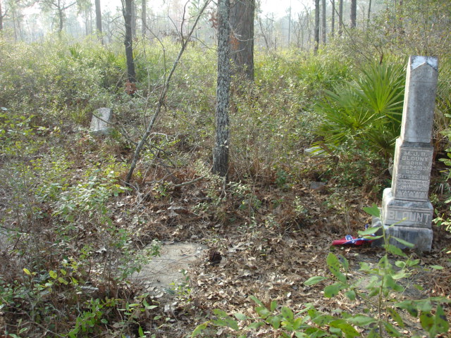
| Description | : | Williams Chapel Cemetery was also known as Black Pond Cemetery. It is located in the Snipesville community in Jeff Davis County Georgia. It is in a small wooded area near fields that are tended. It is not known how many graves are located here, but 6 are visable today. |
frequently asked questions (FAQ):
-
Where is Williams Chapel Cemetery?
Williams Chapel Cemetery is located at Snipesville, Jeff Davis County ,Georgia ,USA.
-
Williams Chapel Cemetery cemetery's updated grave count on graveviews.com?
0 memorials
-
Where are the coordinates of the Williams Chapel Cemetery?
Latitude: 31.7154700
Longitude: -82.7562800
Nearby Cemetories:
1. Carver Chapel Cemetery
Denton, Jeff Davis County, USA
Coordinate: 31.6945160, -82.8036650
2. Mount Pleasant Baptist Church Cemetery
Snipesville, Jeff Davis County, USA
Coordinate: 31.7219980, -82.8118520
3. Annie Reed Cemetery
Jeff Davis County, USA
Coordinate: 31.7225417, -82.6895083
4. Denton Cemetery
Denton, Jeff Davis County, USA
Coordinate: 31.7260200, -82.6887500
5. Creech Cemetery
Snipesville, Jeff Davis County, USA
Coordinate: 31.7752060, -82.7480360
6. Piney Grove Baptist Church Cemetery
Hazlehurst, Jeff Davis County, USA
Coordinate: 31.7818800, -82.8050700
7. Union Springs Baptist Church Cemetery
Snipesville, Jeff Davis County, USA
Coordinate: 31.7936470, -82.7640810
8. Burkett Cemetery
Coffee County, USA
Coordinate: 31.6508007, -82.6952972
9. Saint Andrews Cemetery
Coffee County, USA
Coordinate: 31.7514000, -82.8442001
10. Mary's Chapel Methodist Cemetery
Broxton, Coffee County, USA
Coordinate: 31.6706800, -82.8388350
11. Providence Baptist Church Cemetery
Douglas, Coffee County, USA
Coordinate: 31.6455970, -82.8121950
12. Hand Family Cemetery
Hazlehurst, Jeff Davis County, USA
Coordinate: 31.7981180, -82.6957100
13. Ward Cemetery
Coffee County, USA
Coordinate: 31.6142006, -82.7446976
14. Smith Family Cemetery
Pridgen, Coffee County, USA
Coordinate: 31.7667410, -82.8651950
15. Oak Grove AME Church Cemetery #2
West Green, Coffee County, USA
Coordinate: 31.6093900, -82.7838820
16. Lone Hill Cemetery
Coffee County, USA
Coordinate: 31.6063995, -82.7778015
17. Hayes Family Cemetery
Snipesville, Jeff Davis County, USA
Coordinate: 31.8231930, -82.7263820
18. Ashley-Manning-Pace Cemetery
Kirkland, Jeff Davis County, USA
Coordinate: 31.7907800, -82.8516800
19. Oak Grove AME Church Cemetery
Coffee County, USA
Coordinate: 31.6035995, -82.7613983
20. Rocky Creek Cemetery
Coffee County, USA
Coordinate: 31.7572002, -82.8786011
21. Cato Cemetery
Broxton, Coffee County, USA
Coordinate: 31.6368999, -82.8514023
22. Mims Family Cemetery
Hazlehurst, Jeff Davis County, USA
Coordinate: 31.7346970, -82.6230350
23. Calvary Full Gospel Tabernacle Cemetery
West Green, Coffee County, USA
Coordinate: 31.6002140, -82.7392430
24. Simmons Cemetery
Jeff Davis County, USA
Coordinate: 31.6952991, -82.6194000