
| Memorials | : | 0 |
| Location | : | Union, Boone County, USA |
| Coordinate | : | 38.9580560, -84.7027780 |
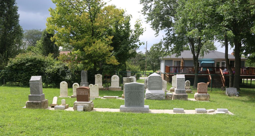
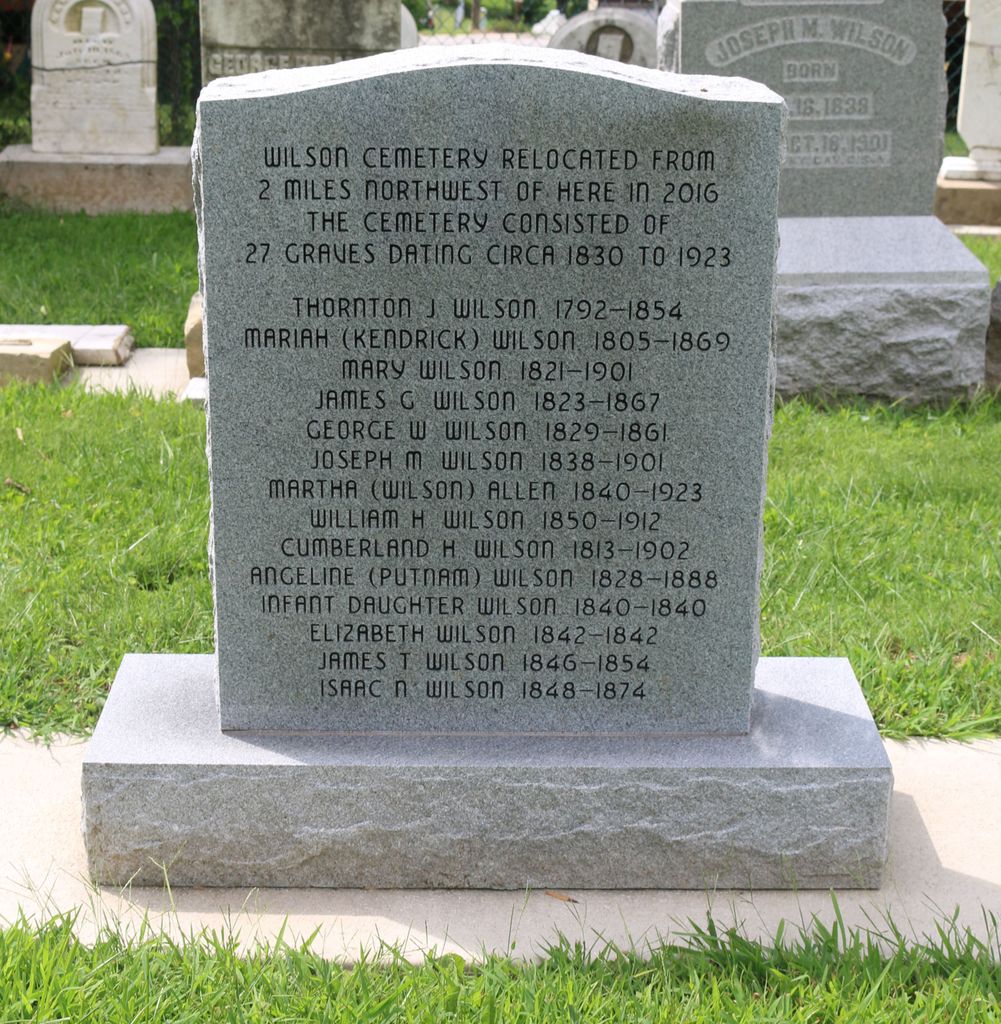
| Description | : | The cemetery was located about 2000 feet northwest of the north end of Spruce Lane. Burials occurred from 1840 through 1923. All bodies and monuments were relocated to the Union Rice Cemetery in July 2016. The Boone County GIS unique ID assigned to this cemetery is 191 (Wilson Cemetery). The cemetery has an index number of 192 (Wilson) on the Boone County Kentucky Cemetery Map published in 2005 by the Boone County Planning Commission in conjunction with Johnson-Wilson Cemetery Stewards Association. The cemetery is identified as the Wilson Cemetery in the Boone County Family Cemetery Register, Volume 2, compiled by the Boone... Read More |
frequently asked questions (FAQ):
-
Where is Wilson Cemetery (Defunct)?
Wilson Cemetery (Defunct) is located at Spruce Lane Union, Boone County ,Kentucky , 41091USA.
-
Wilson Cemetery (Defunct) cemetery's updated grave count on graveviews.com?
0 memorials
-
Where are the coordinates of the Wilson Cemetery (Defunct)?
Latitude: 38.9580560
Longitude: -84.7027780
Nearby Cemetories:
1. Adams-Riley Cemetery
Union, Boone County, USA
Coordinate: 38.9480560, -84.7019440
2. Smith Cemetery
Union, Boone County, USA
Coordinate: 38.9677780, -84.6969440
3. Hagish Cemetery
Union, Boone County, USA
Coordinate: 38.9750290, -84.7180510
4. Blankenbeker Family Cemetery #2
Florence, Boone County, USA
Coordinate: 38.9816670, -84.7072230
5. Blankenbeker Family Cemetery #1
Florence, Boone County, USA
Coordinate: 38.9820220, -84.6990250
6. Stansifer-Utz Cemetery
Union, Boone County, USA
Coordinate: 38.9419289, -84.6791534
7. Stanton Aylor Cemetery (Defunct)
Florence, Boone County, USA
Coordinate: 38.9675900, -84.6718100
8. Hamilton Cemetery
Union, Boone County, USA
Coordinate: 38.9547410, -84.6687910
9. Elizabeth Utz Cemetery
Oakbrook, Boone County, USA
Coordinate: 38.9839850, -84.7122910
10. Hugh Steers Burial Site
Florence, Boone County, USA
Coordinate: 38.9340280, -84.6865210
11. Aylor Cemetery
Limaburg, Boone County, USA
Coordinate: 38.9830570, -84.7177780
12. Delph Cemetery
Florence, Boone County, USA
Coordinate: 38.9844440, -84.6911110
13. Union Rice Cemetery
Union, Boone County, USA
Coordinate: 38.9481010, -84.6675034
14. Snyder-Crisler Cemetery
Burlington, Boone County, USA
Coordinate: 38.9867750, -84.7183080
15. Crisler Family Cemetery
Burlington, Boone County, USA
Coordinate: 38.9858330, -84.7230560
16. Tanner-Utz Cemetery (Defunct)
Florence, Boone County, USA
Coordinate: 38.9736110, -84.6655560
17. Abraham Rouse Cemetery
Florence, Boone County, USA
Coordinate: 38.9758330, -84.6672220
18. Philip Baker Cemetery (Defunct)
Union, Boone County, USA
Coordinate: 38.9338890, -84.6730560
19. A.S. Crisler Cemetery
Florence, Boone County, USA
Coordinate: 38.9916590, -84.7020550
20. Barlow Family Cemetery
Florence, Boone County, USA
Coordinate: 38.9881990, -84.6827190
21. Bethel Baptist Church Cemetery
Union, Boone County, USA
Coordinate: 38.9356040, -84.6677790
22. Tanner Family Cemetery
Florence, Boone County, USA
Coordinate: 38.9653710, -84.6551220
23. Cleek Cemetery (Defunct)
Union, Boone County, USA
Coordinate: 38.9341620, -84.6634140
24. Piper Family Cemetery
Florence, Boone County, USA
Coordinate: 38.9555050, -84.6514690