
| Memorials | : | 1 |
| Location | : | Union, Boone County, USA |
| Coordinate | : | 38.9419289, -84.6791534 |
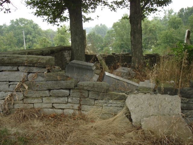
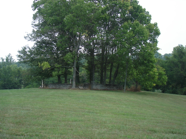
| Description | : | The cemetery is located on the west side of Old Union Road about 900 feet northwest of its junction with US 42 / US 127. The Boone County GIS unique ID assigned to this cemetery is 158 (Stansifer-Utz Cemetery). The cemetery has an index number of 160 (Stansifer-Utz) on the Boone County Kentucky Cemetery Map published in 2005 by the Boone County Planning Commission in conjunction with Johnson-Wilson Cemetery Stewards Association. The cemetery is identified as Stansiffer/Utz (US 42) in the index and listed as Stansifer & Utz Cemetery on page 308 of the book “Boone County, Kentucky Cemeteries” by Stephen W. Worrel,... Read More |
frequently asked questions (FAQ):
-
Where is Stansifer-Utz Cemetery?
Stansifer-Utz Cemetery is located at Old Union Road Union, Boone County ,Kentucky , 41091USA.
-
Stansifer-Utz Cemetery cemetery's updated grave count on graveviews.com?
1 memorials
-
Where are the coordinates of the Stansifer-Utz Cemetery?
Latitude: 38.9419289
Longitude: -84.6791534
Nearby Cemetories:
1. Philip Baker Cemetery (Defunct)
Union, Boone County, USA
Coordinate: 38.9338890, -84.6730560
2. Hugh Steers Burial Site
Florence, Boone County, USA
Coordinate: 38.9340280, -84.6865210
3. Bethel Baptist Church Cemetery
Union, Boone County, USA
Coordinate: 38.9356040, -84.6677790
4. Union Rice Cemetery
Union, Boone County, USA
Coordinate: 38.9481010, -84.6675034
5. Cleek Cemetery (Defunct)
Union, Boone County, USA
Coordinate: 38.9341620, -84.6634140
6. Hamilton Cemetery
Union, Boone County, USA
Coordinate: 38.9547410, -84.6687910
7. Clarkson Family Cemetery
Union, Boone County, USA
Coordinate: 38.9401620, -84.6559290
8. Carter Family Cemetery
Union, Boone County, USA
Coordinate: 38.9370090, -84.6565470
9. Adams-Riley Cemetery
Union, Boone County, USA
Coordinate: 38.9480560, -84.7019440
10. Wilson Cemetery (Defunct)
Union, Boone County, USA
Coordinate: 38.9580560, -84.7027780
11. Piper Family Cemetery
Florence, Boone County, USA
Coordinate: 38.9555050, -84.6514690
12. Marshall Family Cemetery
Union, Boone County, USA
Coordinate: 38.9438890, -84.6455560
13. Stanton Aylor Cemetery (Defunct)
Florence, Boone County, USA
Coordinate: 38.9675900, -84.6718100
14. Smith Cemetery
Union, Boone County, USA
Coordinate: 38.9677780, -84.6969440
15. Tanner Family Cemetery
Florence, Boone County, USA
Coordinate: 38.9653710, -84.6551220
16. Booth Family Cemetery
Union, Boone County, USA
Coordinate: 38.9265990, -84.6450410
17. Butts-Snow-Loar Cemetery
Union, Boone County, USA
Coordinate: 38.9328660, -84.6396090
18. Tanner-Utz Cemetery (Defunct)
Florence, Boone County, USA
Coordinate: 38.9736110, -84.6655560
19. Abraham Rouse Cemetery
Florence, Boone County, USA
Coordinate: 38.9758330, -84.6672220
20. Grubbs Cemetery
Richwood, Boone County, USA
Coordinate: 38.9366260, -84.6262810
21. Zimmerman Cemetery (Defunct)
Florence, Boone County, USA
Coordinate: 38.9825000, -84.6616670
22. Carpenter Cemetery
Boone County, USA
Coordinate: 38.9258070, -84.6281840
23. Holsclaw Cemetery
Florence, Boone County, USA
Coordinate: 38.9802430, -84.6541820
24. Blankenbeker Family Cemetery #1
Florence, Boone County, USA
Coordinate: 38.9820220, -84.6990250