
| Memorials | : | 0 |
| Location | : | Cross Plains, Carroll County, USA |
| Coordinate | : | 33.5582760, -84.9677470 |
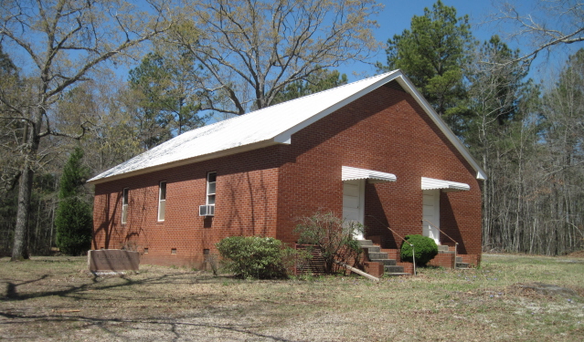
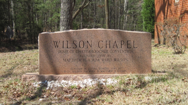
| Description | : | From Carrollton at the Bypass, take Old Newnan Road to Cross Plains Road to Hutcheson Ferry Road (about 5.2 miles) and turn right. The chapel and cemetery are 0.5 mile on the left side of the road. A memorial marker placed beside the church building reads: Wilson Chapel, Home of Chattahoochee Convention, Founded 1938 by Matthew H. and Ada Ward Wilson, Donated in Loving Memory 1990 by Mary Wilson Hackney and Matthew B. Wilson. |
frequently asked questions (FAQ):
-
Where is Wilson Chapel Cemetery?
Wilson Chapel Cemetery is located at Cross Plains, Carroll County ,Georgia ,USA.
-
Wilson Chapel Cemetery cemetery's updated grave count on graveviews.com?
0 memorials
-
Where are the coordinates of the Wilson Chapel Cemetery?
Latitude: 33.5582760
Longitude: -84.9677470

Nearby Cemetories:
1. Wilson Cemetery
Carroll County, USA
Coordinate: 33.5567017, -84.9655991
2. Cross Plains Baptist Church Cemetery
Cross Plains, Carroll County, USA
Coordinate: 33.5583000, -84.9756012
3. Cross Plains Christian Church Cemetery
Carrollton, Carroll County, USA
Coordinate: 33.5600014, -84.9775009
4. Kiser Cemetery
Carroll County, USA
Coordinate: 33.5692000, -84.9737660
5. Gilley Cemetery
Cross Plains, Carroll County, USA
Coordinate: 33.5459200, -84.9777460
6. Hinesley Cemetery
Cross Plains, Carroll County, USA
Coordinate: 33.5675011, -84.9514008
7. Mount Carmel Church Cemetery
Cross Plains, Carroll County, USA
Coordinate: 33.5746994, -84.9744034
8. Sparks Cemetery
Dingler Crossroads, Carroll County, USA
Coordinate: 33.5429840, -84.9445500
9. Driver-Boon-Bearden Family Cemetery
Carrollton, Carroll County, USA
Coordinate: 33.5353710, -84.9556820
10. New Hope Baptist Church Cemetery
Carroll County, USA
Coordinate: 33.5948050, -84.9773390
11. Antioch Missionary Baptist Church Cemetery
Carrollton, Carroll County, USA
Coordinate: 33.5311012, -85.0036011
12. Bandy Cemetery
Oak Mountain, Carroll County, USA
Coordinate: 33.5811790, -85.0128400
13. Latimer Cemetery
Carrollton, Carroll County, USA
Coordinate: 33.5815190, -85.0126790
14. Pleasant Hill Baptist Cemetery
Carroll County, USA
Coordinate: 33.5802994, -85.0136032
15. Consolation Baptist Church Cemetery
Whitesburg, Carroll County, USA
Coordinate: 33.5731010, -84.9171982
16. Bushby Church Cemetery
Carrollton, Carroll County, USA
Coordinate: 33.5843290, -84.9204109
17. Saint Paul Methodist Church Cemetery
Whitesburg, Carroll County, USA
Coordinate: 33.5503006, -84.9094009
18. Beulahland Baptist Church Cemetery
Carrollton, Carroll County, USA
Coordinate: 33.5928690, -85.0098680
19. Antioch Primitive Baptist Church Cemetery
Banning, Carroll County, USA
Coordinate: 33.5181007, -84.9321976
20. Harper Cemetery
Clem, Carroll County, USA
Coordinate: 33.5132490, -84.9936250
21. Corinth Baptist Church Cemetery
Whitesburg, Carroll County, USA
Coordinate: 33.5231018, -84.9233017
22. Clem Cemetery
Clem, Carroll County, USA
Coordinate: 33.5243988, -85.0160980
23. Happy Hill Cemetery
Carrollton, Carroll County, USA
Coordinate: 33.5043983, -84.9888992
24. Gray Family Cemetery
Carrollton, Carroll County, USA
Coordinate: 33.5025160, -84.9822250