
| Memorials | : | 0 |
| Location | : | Atlanta, Fulton County, USA |
| Coordinate | : | 33.8248610, -84.3877780 |
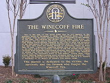
| Description | : | This is a memorial for the 119 people who lost their lives in the Winecoff Hotel fire on December 7th, 1946, known today has the Ellis Hotel, located at 176 Peachtree Street NW, in downtown Atlanta, Georgia. The Winecoff Hotel was designed by William Lee Stoddart, the 15-story building opened in 1913. It was located next to the former Macy's (at 180 Peachtree Street), which was built as the flagship Davison's, and just south from the Westin Peachtree Plaza Hotel (easily identifiable by its cylindrical glass design). It was listed on the National Register of Historic Places on March 31st,... Read More |
frequently asked questions (FAQ):
-
Where is Winecoff Hotel Historical Marker?
Winecoff Hotel Historical Marker is located at Atlanta, Fulton County ,Georgia ,USA.
-
Winecoff Hotel Historical Marker cemetery's updated grave count on graveviews.com?
0 memorials
-
Where are the coordinates of the Winecoff Hotel Historical Marker?
Latitude: 33.8248610
Longitude: -84.3877780
Nearby Cemetories:
1. Cathedral of Saint Philip Memorial Garden
Atlanta, Fulton County, USA
Coordinate: 33.8301000, -84.3874300
2. Northside United Methodist Church Memorial Garden
Atlanta, Fulton County, USA
Coordinate: 33.8313500, -84.4060600
3. Mount Olive Cemetery
Buckhead, Fulton County, USA
Coordinate: 33.8368300, -84.3725900
4. New Hope African Methodist Episcopal Cemetery
Atlanta, Fulton County, USA
Coordinate: 33.8376200, -84.4042500
5. Harmony Grove Cemetery
Buckhead, Fulton County, USA
Coordinate: 33.8440800, -84.3919200
6. Peachtree Road United Methodist Church Columbarium
Atlanta, Fulton County, USA
Coordinate: 33.8418770, -84.3756460
7. Peachtree Presbyterian Church Columbarium
Atlanta, Fulton County, USA
Coordinate: 33.8473360, -84.3826100
8. Piney Grove Cemetery
Atlanta, Fulton County, USA
Coordinate: 33.8297500, -84.3591900
9. Rock Spring Presbyterian Church Cemetery
Atlanta, Fulton County, USA
Coordinate: 33.8050200, -84.3678000
10. Trinity Presbyterian Church Memorial Gardens
Atlanta, Fulton County, USA
Coordinate: 33.8374180, -84.4173650
11. Northside Park Baptist Church Cemetery
Atlanta, Fulton County, USA
Coordinate: 33.8061870, -84.4127510
12. Old Mount Zion Cemetery
Atlanta, Fulton County, USA
Coordinate: 33.8061800, -84.4128000
13. Peachtree Christian Church
Atlanta, Fulton County, USA
Coordinate: 33.7969090, -84.3897290
14. Saint Anne's Episcopal Church Memorial Garden
Atlanta, Fulton County, USA
Coordinate: 33.8395200, -84.4184900
15. Sardis United Methodist Church Cemetery
Atlanta, Fulton County, USA
Coordinate: 33.8577900, -84.3840400
16. First Presbyterian Church Memorial Garden
Atlanta, Fulton County, USA
Coordinate: 33.7908050, -84.3855460
17. Smith Family Cemetery
Atlanta, Fulton County, USA
Coordinate: 33.8221100, -84.4344900
18. Fulton County Almshouse Cemetery
Buckhead, Fulton County, USA
Coordinate: 33.8694740, -84.3905110
19. Peachtree Baptist Cemetery
Atlanta, DeKalb County, USA
Coordinate: 33.8149030, -84.3351190
20. Crest Lawn Cemetery
Atlanta, Fulton County, USA
Coordinate: 33.8064003, -84.4428024
21. Church of Our Saviour Our Lady Chapel Columbarium
Atlanta, Fulton County, USA
Coordinate: 33.7837360, -84.3549140
22. St Joseph of Arimethaea Memorial Gardens
Atlanta, DeKalb County, USA
Coordinate: 33.8176900, -84.3287400
23. Redeemer Lutheran Columbarium
Atlanta, Fulton County, USA
Coordinate: 33.7746660, -84.3844390
24. Casey's Hill Cemetery
Atlanta, Fulton County, USA
Coordinate: 33.8108660, -84.4460890