
| Memorials | : | 8 |
| Location | : | Milford Center, Union County, USA |
| Coordinate | : | 40.1699982, -83.4056015 |
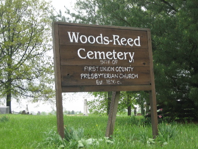
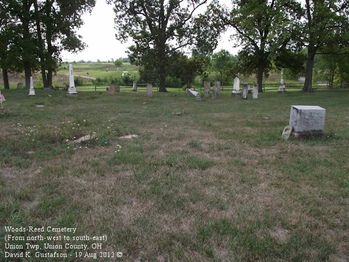
| Description | : | The cemetery is located on the northeast side of Orchard Road (County Road 69) about 800 feet southeast of its intersection with Sam Reed Road (County Road 62). The cemetery is located in Union Township, Union County, Ohio, and is # 12009 (Woods Cemetery) and # 12007 (Presbyterian Cemetery / Upper Liberty Cemetery) in “Ohio Cemeteries 1803-2003”, compiled by the Ohio Genealogical Society. The U.S. Geological Survey (USGS) Geographic Names Information System (GNIS) feature ID for the cemetery is 1048103 (Woods Cemetery). |
frequently asked questions (FAQ):
-
Where is Woods-Reed Cemetery?
Woods-Reed Cemetery is located at Orchard Road (County Road 69) Milford Center, Union County ,Ohio , 43040USA.
-
Woods-Reed Cemetery cemetery's updated grave count on graveviews.com?
7 memorials
-
Where are the coordinates of the Woods-Reed Cemetery?
Latitude: 40.1699982
Longitude: -83.4056015
Nearby Cemetories:
1. Milford Center Cemetery
Milford Center, Union County, USA
Coordinate: 40.1770134, -83.4267349
2. Mitchell Cemetery
Darby Township, Union County, USA
Coordinate: 40.1513280, -83.3822250
3. Saint Paul Lutheran Cemetery
Chuckery, Union County, USA
Coordinate: 40.1510773, -83.3819427
4. Darby Township Unidentified Cemetery #2
Darby Township, Union County, USA
Coordinate: 40.1515580, -83.3732780
5. Saint Johns Cemetery
Marysville, Union County, USA
Coordinate: 40.1878014, -83.3553009
6. Trinity Lutheran Cemetery
Marysville, Union County, USA
Coordinate: 40.2040600, -83.3666800
7. Old Saint Johns Lutheran Cemetery
Marysville, Union County, USA
Coordinate: 40.1958670, -83.3544810
8. McDonald Cemetery
Milford Center, Union County, USA
Coordinate: 40.2030983, -83.4516983
9. Connor Cemetery
Milford Center, Union County, USA
Coordinate: 40.1577988, -83.4741974
10. Darby Township Unidentified Cemetery #1
Darby Township, Union County, USA
Coordinate: 40.2000250, -83.3455110
11. New Darby Cemetery
Unionville Center, Union County, USA
Coordinate: 40.1403008, -83.3447037
12. Old Darby Cemetery
Unionville Center, Union County, USA
Coordinate: 40.1394005, -83.3432999
13. Lighthouse Mennonite Fellowship Church Cemetery
Unionville Center, Union County, USA
Coordinate: 40.1425944, -83.3378769
14. Bigelow Pioneer Cemetery
Madison County, USA
Coordinate: 40.1096992, -83.4197006
15. Crane Swamp Cemetery
Union Township, Union County, USA
Coordinate: 40.1938475, -83.4801557
16. Buck Run Cemetery
Allen Township, Union County, USA
Coordinate: 40.2243996, -83.4608002
17. Shanklin Family Cemetery
Union Township, Union County, USA
Coordinate: 40.1569460, -83.4961440
18. Oakdale Cemetery
Marysville, Union County, USA
Coordinate: 40.2442017, -83.3944016
19. Marysville Cemetery
Marysville, Union County, USA
Coordinate: 40.2381180, -83.3636390
20. Potters Field
Marysville, Union County, USA
Coordinate: 40.2456250, -83.3934830
21. Our Lady of Lourdes Catholic Cemetery
Marysville, Union County, USA
Coordinate: 40.2458000, -83.3918991
22. Amrine Cemetery
Paris Township, Union County, USA
Coordinate: 40.2500000, -83.3936005
23. Mount Zion Cemetery
Marysville, Union County, USA
Coordinate: 40.2518997, -83.4180984
24. Martin Cemetery
Woodstock, Champaign County, USA
Coordinate: 40.1893997, -83.5180969