
| Memorials | : | 10 |
| Location | : | Hannibal, Monroe County, USA |
| Coordinate | : | 39.6816400, -80.9091800 |
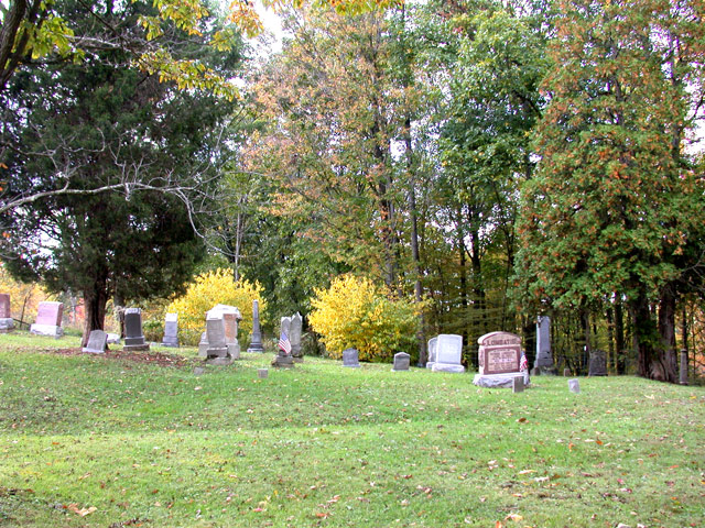
| Description | : | This Cemetery is Located on state Route 536 about 3 miles from Hannibal, Monroe County, Ohio. The Cemetery wraps around two sides of the church. It is not the same cemetery as the Zion Methodist Church, also in Monroe County. It is located near the Zion Memorial Gardens. The cemetery was established in 1846 and is 0.43 acres in size. The cemetery is located in Ohio Township, Monroe County, Ohio, and is # 8142 (Zion Cemetery / Mount Zion Cemetery) in “Ohio Cemeteries 1803-2003”, compiled by the Ohio Genealogical Society. The U.S. Geological Survey (USGS) Geographic Names Information System (GNIS)... Read More |
frequently asked questions (FAQ):
-
Where is Zion Evangelical Cemetery?
Zion Evangelical Cemetery is located at Ohio State Route 536 Hannibal, Monroe County ,Ohio , 43915USA.
-
Zion Evangelical Cemetery cemetery's updated grave count on graveviews.com?
10 memorials
-
Where are the coordinates of the Zion Evangelical Cemetery?
Latitude: 39.6816400
Longitude: -80.9091800


Nearby Cemetories:
1. Zion Memorial Gardens
Sardis, Monroe County, USA
Coordinate: 39.6788630, -80.9093820
2. Saint Johns Methodist Church Cemetery
Goodwin, Monroe County, USA
Coordinate: 39.6684914, -80.9221802
3. Apostolic Church Cemetery
Ohio Township, Monroe County, USA
Coordinate: 39.6554460, -80.9092250
4. Mount Union Cemetery
Hannibal, Monroe County, USA
Coordinate: 39.7003500, -80.8839900
5. Emma Grove Cemetery
Hannibal, Monroe County, USA
Coordinate: 39.6713982, -80.8752975
6. Harter Cemetery
Hannibal, Monroe County, USA
Coordinate: 39.6756020, -80.8692880
7. Old Hannibal Cemetery
Monroe County, USA
Coordinate: 39.6669810, -80.8692950
8. Salem Cemetery
Sardis, Monroe County, USA
Coordinate: 39.6650840, -80.9496380
9. Mount Moriah Cemetery
Monroe County, USA
Coordinate: 39.6577988, -80.9488983
10. Greenlawn Memorial Park
New Martinsville, Wetzel County, USA
Coordinate: 39.6755981, -80.8591995
11. Williams Cemetery
New Martinsville, Wetzel County, USA
Coordinate: 39.6688995, -80.8589020
12. Northview Cemetery
New Martinsville, Wetzel County, USA
Coordinate: 39.6730995, -80.8566971
13. Lude Cemetery
Clarington, Monroe County, USA
Coordinate: 39.7189270, -80.8792370
14. Fuchs Cemetery
Laings, Monroe County, USA
Coordinate: 39.7109080, -80.9545449
15. Mount Olive Cemetery
Monroe County, USA
Coordinate: 39.6556300, -80.9587100
16. Mount Vernon Cemetery
Clarington, Monroe County, USA
Coordinate: 39.7120207, -80.8634298
17. Duffy Cemetery
Duffy, Monroe County, USA
Coordinate: 39.6436190, -80.8730500
18. Sardis Cemetery
Sardis, Monroe County, USA
Coordinate: 39.6259100, -80.9151000
19. Buck Hill Bottom Cemetery
Hannibal, Monroe County, USA
Coordinate: 39.7022980, -80.8412070
20. Ollum Cemetery
Monroe County, USA
Coordinate: 39.7259100, -80.8631500
21. Parker Cemetery
Sardis, Monroe County, USA
Coordinate: 39.6519012, -80.9764023
22. Kraft Cemetery
Monroe County, USA
Coordinate: 39.7224998, -80.9664001
23. Saint James Lutheran Cemetery
Clarington, Monroe County, USA
Coordinate: 39.7411820, -80.9238030
24. Mount Sinai Methodist Cemetery
Clarington, Monroe County, USA
Coordinate: 39.7409090, -80.8923190