
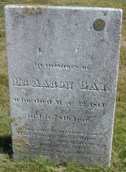

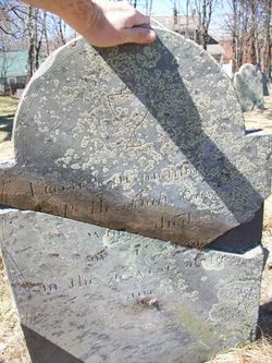
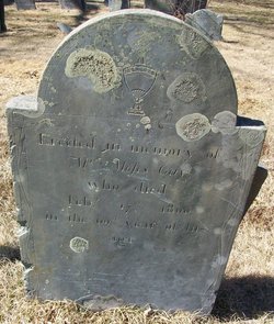
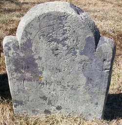
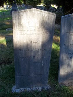
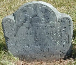
Aaron Gay
| Birth | : | 24 Dec 1735 Suffolk County, Massachusetts, USA |
| Death | : | 22 May 1813 Stoughton, Norfolk County, Massachusetts, USA |
| Burial | : | Dorchester Memorial Cemetery, Dorchester, Clark County, USA |
| Coordinate | : | 44.9962000, -90.3366000 |
| Description | : | He was a veteran of the Revolutionary War serving in Wood's Mass. Inf. He died in his 78th year. |
frequently asked questions (FAQ):
-
Where is Aaron Gay's memorial?
Aaron Gay's memorial is located at: Dorchester Memorial Cemetery, Dorchester, Clark County, USA.
-
When did Aaron Gay death?
Aaron Gay death on 22 May 1813 in Stoughton, Norfolk County, Massachusetts, USA
-
Where are the coordinates of the Aaron Gay's memorial?
Latitude: 44.9962000
Longitude: -90.3366000
Family Members:
Parent
Spouse
Siblings


Children
Flowers:


Nearby Cemetories:
1. Dorchester Memorial Cemetery
Dorchester, Clark County, USA
Coordinate: 44.9962000, -90.3366000
2. Popple Ridge Mennonite Church Cemetery
Dorchester, Clark County, USA
Coordinate: 44.9860940, -90.3369020
3. Norwegian Evangelical Lutheran Cemetery
Dorchester, Clark County, USA
Coordinate: 45.0059000, -90.3293000
4. North Dorchester Memorial Cemetery
Dorchester, Clark County, USA
Coordinate: 45.0099983, -90.3352966
5. Abbotsford Cemetery
Abbotsford, Clark County, USA
Coordinate: 44.9562000, -90.3173000
6. Lindeman Cemetery
Dorchester, Clark County, USA
Coordinate: 45.0018600, -90.4015200
7. Christ Lutheran Cemetery
Holton, Marathon County, USA
Coordinate: 44.9600910, -90.2801080
8. Stetsonville Public Cemetery
Stetsonville, Taylor County, USA
Coordinate: 45.0600000, -90.3151000
9. Zion Cemetery
Stetsonville, Taylor County, USA
Coordinate: 45.0621986, -90.3153000
10. Pine Hill Cemetery
Curtiss, Clark County, USA
Coordinate: 44.9735985, -90.4332962
11. Sacred Heart Cemetery
Stetsonville, Taylor County, USA
Coordinate: 45.0766983, -90.3296967
12. Saint Paul Lutheran Cemetery
Curtiss, Clark County, USA
Coordinate: 44.9580000, -90.4489000
13. Colby Cemetery
Colby, Clark County, USA
Coordinate: 44.9033012, -90.3360977
14. Saint Marys Catholic Cemetery
Colby, Clark County, USA
Coordinate: 44.9023000, -90.3361000
15. Colby Mennonite Cemetery
Colby, Clark County, USA
Coordinate: 44.9158000, -90.4258300
16. Sunny Ridge Mennonite Cemetery
Curtiss, Clark County, USA
Coordinate: 44.9624700, -90.4739400
17. Pilgrim Rest Cemetery
Milan, Marathon County, USA
Coordinate: 44.9744100, -90.1901400
18. Saint Marys Cemetery
Stetsonville, Taylor County, USA
Coordinate: 45.0936000, -90.3967000
19. Saint Paul Lutheran Cemetery
Colby, Clark County, USA
Coordinate: 44.9089000, -90.4337000
20. Bethlehem Lutheran Cemetery
Milan, Marathon County, USA
Coordinate: 44.9878006, -90.1791992
21. Saint Thomas Catholic Cemetery
Milan, Marathon County, USA
Coordinate: 44.9883003, -90.1789017
22. Our Saviours Lutheran Church Cemetery
Medford, Taylor County, USA
Coordinate: 45.1033000, -90.4448600
23. Amish Cemetery
Little Black, Taylor County, USA
Coordinate: 45.0993996, -90.4542007
24. Saint Marys Cemetery
Holway, Taylor County, USA
Coordinate: 45.0459950, -90.5164000