
| Birth | : | 1778 Reamstown, Lancaster County, Pennsylvania, USA |
| Death | : | 7 Jun 1833 Fairfield County, Ohio, USA |
| Burial | : | Waikumete Cemetery & Crematorium, Glen Eden, Auckland Council, New Zealand |
| Coordinate | : | -36.9025130, 174.6539610 |
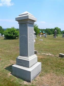
| Plot | : | Shaeffer (Kohler-Shaeffer) |
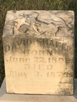
| Inscription | : | Inscription is barely visible. |
| Description | : | Madison Township was established in 1812. The first families in the township were the Shaeffer's. Isaac Shaeffer, Abram Shaeffer, Martin Landis, Sr., and Abram Ream, came from Lancaster County, Pennsylvania, in the spring of 1798. Google: 1883 History of Fairfield & Perry Counties (Part IV "Madison" and Part V "S"). It is believed that Abraham is a descendant of Abraham Shaeffer of Donegal Twp., Lancaster County Pennsylvania and a descendant of Phillip Shaeffer and Mary Liegh, who came from Baden-Baden, Germany and purchased land around 1734 in Earl Township, Lancaster County, Pennsylvania (later to become Lebanon County). Abram Shaeffer... Read More |
frequently asked questions (FAQ):
-
Where is Abraham “Abram” Shaeffer's memorial?
Abraham “Abram” Shaeffer's memorial is located at: Waikumete Cemetery & Crematorium, Glen Eden, Auckland Council, New Zealand.
-
When did Abraham “Abram” Shaeffer death?
Abraham “Abram” Shaeffer death on 7 Jun 1833 in Fairfield County, Ohio, USA
-
Where are the coordinates of the Abraham “Abram” Shaeffer's memorial?
Latitude: -36.9025130
Longitude: 174.6539610
Family Members:
Spouse

Children
Flowers:


Nearby Cemetories:
1. Waikumete Cemetery & Crematorium
Glen Eden, Auckland Council, New Zealand
Coordinate: -36.9025130, 174.6539610
2. Auckland Provincial Memorial
Glen Eden, Auckland Council, New Zealand
Coordinate: -36.9020700, 174.6548500
3. Oratia Cemetery
Oratia, Auckland Council, New Zealand
Coordinate: -36.9108800, 174.6218900
4. Settlers Cemetery
Oratia, Auckland Council, New Zealand
Coordinate: -36.9108770, 174.6218870
5. George Maxwell Memorial Cemetery
Avondale, Auckland Council, New Zealand
Coordinate: -36.8890320, 174.6849320
6. Saint Ninians Churchyard
Avondale, Auckland Council, New Zealand
Coordinate: -36.8994510, 174.6966690
7. Oratia Combined Church Cemetery
Oratia, Auckland Council, New Zealand
Coordinate: -36.9196396, 174.6119362
8. Swanson Cemetery
Swanson, Auckland Council, New Zealand
Coordinate: -36.8718400, 174.5836200
9. St. Luke's Anglican Church Cemetery
Mount Albert, Auckland Council, New Zealand
Coordinate: -36.8785540, 174.7290400
10. Hillsborough Cemetery
Hillsborough, Auckland Council, New Zealand
Coordinate: -36.9246600, 174.7524030
11. Saint Andrew's Churchyard
Epsom, Auckland Council, New Zealand
Coordinate: -36.8937200, 174.7654100
12. Mount Eden Stockade Cemetery
Mount Eden, Auckland Council, New Zealand
Coordinate: -36.8678370, 174.7666430
13. Symonds Street Cemetery
Auckland, Auckland Council, New Zealand
Coordinate: -36.8582828, 174.7636628
14. Hobsonville Church and Settlers' Cemetery
Hobsonville, Auckland Council, New Zealand
Coordinate: -36.8000500, 174.6551800
15. St Mark's Anglican Church Cemetery
Remuera, Auckland Council, New Zealand
Coordinate: -36.8729300, 174.7801600
16. St. Peter's Anglican Cemetery
Ōnehunga, Auckland Council, New Zealand
Coordinate: -36.9227113, 174.7847550
17. Our Lady of the Assumption Catholic Church
Ōnehunga, Auckland Council, New Zealand
Coordinate: -36.9223690, 174.7884530
18. Onehunga Catholic Cemetery
Ōnehunga, Auckland Council, New Zealand
Coordinate: -36.9224360, 174.7884560
19. Mangere Piriti Urupā St. James Churchyard
Mangere, Auckland Council, New Zealand
Coordinate: -36.9418970, 174.7835260
20. Pompallier Cemetery
Birkenhead, Auckland Council, New Zealand
Coordinate: -36.8036900, 174.7251200
21. Waikaraka Cemetery
Ōnehunga, Auckland Council, New Zealand
Coordinate: -36.9297140, 174.7967170
22. Birkenhead-Glenfield Cemetery
Birkenhead, Auckland Council, New Zealand
Coordinate: -36.7989000, 174.7234700
23. St. Stephen's Churchyard
Auckland, Auckland Council, New Zealand
Coordinate: -36.8504860, 174.7899970
24. Mangere Lawn Cemetery
Mangere, Auckland Council, New Zealand
Coordinate: -36.9626150, 174.7857000