
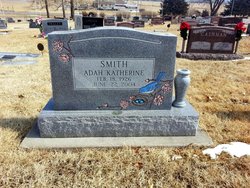
Adah Katherine “Katie” Martin Smith
| Birth | : | 18 Feb 1926 Burlington, Coffey County, Kansas, USA |
| Death | : | 22 Jun 2004 Holton, Jackson County, Kansas, USA |
| Burial | : | Clinton Public Cemetery, Clinton, Huron County, Canada |
| Coordinate | : | 43.6351790, -81.5293200 |
| Plot | : | Section K |
| Description | : | HOLTON --- Adah Katherine "Katie" Smith, 78, Holton, died Tuesday, June 22, 2004, at Holton Hospital. She was born Feb. 18, 1926, in Burlington, the daughter of Perry P. and Martha Jane Raber Martin. She had lived in Holton since 1971. In addition to being a homemaker, Katie was a waitress and a cook. She loved to garden and enjoyed camping and fishing. She was a member of First Baptist Church in Holton and she belonged to the Arab Temple and Scottish Rite in Topeka. She married Marvin H. Bentley on Sept. 12, 1942, in Burlington. He died in 1960. She married James... Read More |
frequently asked questions (FAQ):
-
Where is Adah Katherine “Katie” Martin Smith's memorial?
Adah Katherine “Katie” Martin Smith's memorial is located at: Clinton Public Cemetery, Clinton, Huron County, Canada.
-
When did Adah Katherine “Katie” Martin Smith death?
Adah Katherine “Katie” Martin Smith death on 22 Jun 2004 in Holton, Jackson County, Kansas, USA
-
Where are the coordinates of the Adah Katherine “Katie” Martin Smith's memorial?
Latitude: 43.6351790
Longitude: -81.5293200
Family Members:
Parent

Spouse
Siblings
Children

Flowers:


Nearby Cemetories:
1. Clinton Public Cemetery
Clinton, Huron County, Canada
Coordinate: 43.6351790, -81.5293200
2. Saint Joseph's Roman Catholic Cemetery
Hullett Township, Huron County, Canada
Coordinate: 43.6421190, -81.4980580
3. Holmesville Memorial Cemetery
Holmesville, Huron County, Canada
Coordinate: 43.6493090, -81.6074690
4. Turners Cemetery
Tuckersmith Township, Huron County, Canada
Coordinate: 43.5734540, -81.4893110
5. Londesborough Cemetery
Londesborough, Huron County, Canada
Coordinate: 43.6977800, -81.4812200
6. Kinburn United Cemetery
Kinburn, Huron County, Canada
Coordinate: 43.6307870, -81.4226600
7. Burns United Church Cemetery
Hullett Township, Huron County, Canada
Coordinate: 43.6720600, -81.4192660
8. Colborne Evangelical Cemetery
Colborne Township, Huron County, Canada
Coordinate: 43.7213800, -81.5891380
9. Hope Chapel Cemetery
Central Huron Township, Huron County, Canada
Coordinate: 43.7297610, -81.5031730
10. Ball's Cemetery
Hullett Township, Huron County, Canada
Coordinate: 43.7344320, -81.5418630
11. Baird's Cemetery
Brucefield, Huron County, Canada
Coordinate: 43.5387800, -81.5678100
12. Blyth Union Cemetery
Blyth, Huron County, Canada
Coordinate: 43.7300034, -81.4564743
13. Varna United-Memorial Cemetery
Stanley Township, Huron County, Canada
Coordinate: 43.5347640, -81.5950790
14. Harpurhey Presbyterian Cemetery
Harpurhey, Huron County, Canada
Coordinate: 43.5601460, -81.4149820
15. Ross United Presbyterian Cemetery
Brucefield, Huron County, Canada
Coordinate: 43.5216200, -81.5169800
16. Maitlandbank Cemetery
Seaforth, Huron County, Canada
Coordinate: 43.5740600, -81.3906500
17. German Evangelical Lutheran Cemetery
Hullett Township, Huron County, Canada
Coordinate: 43.7520530, -81.4856970
18. Bayfield Memorial Cemetery
Stanley Township, Huron County, Canada
Coordinate: 43.5453380, -81.6418570
19. Ross Free Presbyterian Cemetery
Brucefield, Huron County, Canada
Coordinate: 43.5118590, -81.5139350
20. Blyth Memorial Cairn
Blyth, Huron County, Canada
Coordinate: 43.7341580, -81.4242160
21. Blyth Anglican Potter's Historic Cemetery
Blyth, Huron County, Canada
Coordinate: 43.7441000, -81.4327200
22. Egmondville Cemetery
Egmondville, Huron County, Canada
Coordinate: 43.5398400, -81.4074380
23. Bayfield Cemetery
Bayfield, Huron County, Canada
Coordinate: 43.5584200, -81.6830700
24. Saint James Cemetery
Seaforth, Huron County, Canada
Coordinate: 43.5479180, -81.3798530